
|
|
Mountain/Rock |
|---|---|
|
|
46.42164°N / 14.22989°E |
|
|
6758 ft / 2060 m |
|
|
Overview
Geographical structure: Eastern Alps > Karavanke / Karawanken GROUP > Western part.
The Karavanke / Karawanken GROUP are the lowest mountain group in Slovenia. The highest peak is Stol/Hochstuhl (2236m). Karavanke / Karawanken GROUP are divided in two groups: West group and East group. Begunjscica belongs to the East group. Begunjscica is the most popular mountain in the all group as Visevnik in Julian Alps group.
Mountaineers are visiting Begunjscica in all year. In Summer is very popular from S slopes also N slopes and it is not very hard to come on it. The nice marked routes lead you through the beautiful forests, after pastures, meadows and beautiful ridges. In Winter is very popular mountain from north where you have many possibilities for tour and alpinistic skiing. Also from the south is nice for skiing.
Begunjscica doesn`t lead on the main ridge of Karavanke/Karawanken group. It leads more to the south from border with Austria. Between the main ridge on the border and Begunjscica main ridge is beautiful meadow and valley called Zelenica. It is popular small skiing area. It ski lifts are below the N face of Begunjscica on the long screes.
The highest point of Begunjscica is Veliki vrh (2060m).
 |
 |
 |
 |
 |
View from Begunjscica
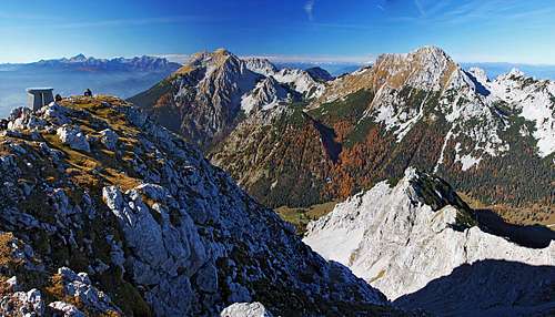 Towards the west: Julian Alps, Stol and Vrtača |
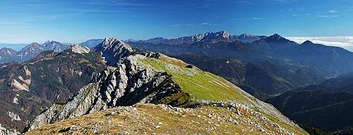 Towards the east: Košuta and Kamnik & Savinja Alps |
Begunjscica has a very good view on other mountains. A landscape is beautiful. You see all valley of Sava with important cities (Ljubljana, Kranj, Bled, Lesce, Jesenice) and villages.
You also see Storzic, Kamnik Alps group and Julian Alps group with Triglav. Stol/Hochstuhl and Vrtaca are directly before you.
Nice view!!!
 |
 |
 |
 |
 |
Getting There
Begunjscica ridge starts on the east by noted frontier with Austria called Ljubelj. Their you convey if you go on Begunjscica from north and from the meadow Zelenica. Here you have a new hut called Dom na Zelenici (the former hut has burnt).
Other possibility is that you drive from Lesce (504m) to the Begunje (616m) and from Begunje first by asphalt road then by macadam road to the Poljska meadow on altitude 1180m. This is accession from south and is popular in Summer. On altitude 1657m you have a Roblekov hut.
There is one more possibility from west side. From Lesce you drive to the Zirovnica and then by macadam road to the Tinckova koca on altitude 1070m. From here you can go to the Roblekov hute from west or to the meadow Zelenica from west over a Smokuska meadow.
Maps:
You can see a detailed map on:
http://www.austrianmap.at/.
That's in German, but as of classical maps, you can refer to:
Karavanke, 1:20000. Planinska zveza Slovenije, or
Karavanke, Central part and Grintovci, 1:50000. Planinska zveza Slovenije
Stol in Begunjscica, 1:25000, Institut for geodesy and photogrammetry
 |
 |
 |
 |
 |
Routes Overview
Some general possibilities are written:
1. Normal route over the S slopes and W ridge. Nice marked route, for kids also. You start from a meadow Poljska and go by Roblekov hut and then over the W ridge. Very popular in Summer and Winter.
2. Route from a meadow Zelenica. You park on Ljubelj and go over the skiing area to the hute on Zelenica. Then you follow secured route across NW slopes and face to the W ridge and to the top. Nice route. It is well if you go here in hot Summer because is not so hot.
3. From Tinckova hut. You drive here from Zirovnica and park by hute. You can go to the Roblekov hut and up over W ridge by Normal route.
Or you go from Tinckova hut to the hute on the meadow Zelenica and then up across N slopes and face.
4. Through the tunnels and over the east ridge
5. Very popular are in Winter ravines on the N face of Begunjscica. I named some of them and I posted also a pictures of some ravines and routes. Tours and alpinistic skiiers have already skied a lot of ravines. The estimations are for skiing:![]() Osrednja grapa (Main ravine) (north side)
Osrednja grapa (Main ravine) (north side)![]() Grapa Y (Ravine Y) (north side)
Grapa Y (Ravine Y) (north side)![]() Smal valley called Levi plaz (tour skiing) Second from Ljubelj
Smal valley called Levi plaz (tour skiing) Second from Ljubelj![]() Small valley Sentanski plaz (north side) (tour skiing)
Small valley Sentanski plaz (north side) (tour skiing) ![]() Small valles called Smokuski plaz (tour skiing) in the W face from Smokuska meadow
Small valles called Smokuski plaz (tour skiing) in the W face from Smokuska meadow
Then a lot of not so important ravines also.
 |
 |
 |
 |
 |
Red Tape
No limitations.
When To Climb
All year. The S slopes are not very popular in hot months but you can go there up also in May, June. The best months for skiing are March and April also when the new snow falls. This can make you a lot of pleasures on heterogeneous slopes of Begunjscica.
 |
 |
 |
 |
Camping
The hut on Zelenica meadows:
Planinski dom na Zelenici, 1536m, Tel.: 04/ 59-71 536.
Roblekov dom pod Begunjscico, 1657m
Planinski dom na Zelenici (hut) has burnt. So now you can only get some drinks but you cannot sleep there!