
|
|
Mountain/Rock |
|---|---|
|
|
38.40180°N / 112.4332°W |
|
|
12122 ft / 3695 m |
|
|
Overview
Baldy Peak is also known as Mount Baldy, depending on which map you are looking at. Locals also know the peak as Beaver Baldy. The name Baldy Peak will be used here, if only for the fact that there are already quite a few Mount Baldy's in Utah. The peak is within the Tushar mountains and located east of Beaver, Utah and West of Marysvale, Utah and about 190 miles south of Salt Lake City.The Tushar Mountains, which at over 12,000 feet are the third-highest mountain range in the state (behind the Uintas and the La Sals) rise from Beaver and I-15 at unbelievable angles and, in afternoon sun, are visible from over 100 miles. When driving I-15 Baldy Peak can clearly be seen popping up on the eastern mountain range.
The range is under the management of Fishlake National Forest and a popular spot, especially in the summer. Baldy Peak is the least climbed of the 12,000+ foot peaks in the Tushars.
Utah's 12,000+ Foot Peaks With 200+ Feet Prominence
Utah's 12,000+ Foot Peaks With 300+ Feet Prominence
 Mount Baldy as seen from the summit of Belknap.
Getting There
BeaverFrom I-15 take Exit 112 and head east and south into the town of Beaver 1.5 miles to state route 153 (Elk Meadows signage). Take left and follow for 16 miles, turn left onto dirt road (Big John Flats). Follow dirt road for 9.9 miles and a sharp switchback to the right. Plenty of parking for about four cars.
Marysvale
From the intersection on Route 89 and bullion Ave head east .60 miles to Beaver Creek road. Turn right onto Beaver Creek road and follow for about 14.5 miles to a sharp switchback to the left. Plenty of parking for about four cars.
I-70
From I-70 take exit 17, get on the north side of I-70 and follow dirt road (Kimberly Road) southwest while paralleling I-70 and than crossing under it while now driving in a southerly direction for about 13.5 miles to an intersection with Beaver Creek road. Turn right onto Beaver Creek Road and follow for about 5.25 miles to a sharp switchback to the left. Plenty of parking for about four cars.
 Baldy from the south while apporaching on Beaver Creek Road.
Routes Overview
The route along the ridge from Mount Belknap may be the most popular route.There is another route from Blue Lake that makes a nice loop of Baldy and Belknap. I will add the route when time is available.
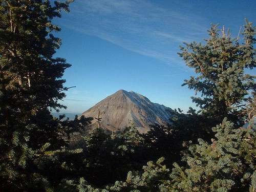 Baldy as seen from the east looking west.
Red Tape
No permits are required.When To Climb
Summer and Fall are the easiest times since Beaver Creek Road is open. In winter, the road may be plowed to the old Elk Meadows Ski Resort, and no farther. In winter, climbing Baldy Peak is a 3-4 day affair. Baldy as seen from Delano, looking north.
Camping
CampgroundsMahogany Grove Campsites
Primitive Camping
There is plenty of camping areas throughout the Big John Flats area.
Mountain Conditions
TUSHAR MOUNTAINS WEATHER FORECASTBelow is the climate summary for nearby Elk Meadows at 10,450 feet elevation, and near the trailheads. These are all averages, so expect more variation, but this will give you a good idea about the climate at higher elevations in the area. *National Weather Service Data.
| MONTH | HIGH | LOW | PRECIP (in) | SNOWFALL (in) |
| JAN | 26 | 1 | 5.51 | 69.9 |
| FEB | 29 | 4 | 4.31 | 61.5 |
| MAR | 34 | 7 | 4.55 | 64.9 |
| APR | 43 | 14 | 3.88 | 45.7 |
| MAY | 52 | 21 | 3.65 | 23.6 |
| JUN | 63 | 30 | 1.19 | 3.0 |
| JUL | 69 | 38 | 2.38 | 0 |
| AUG | 67 | 36 | 2.92 | 0 |
| SEP | 61 | 28 | 2.11 | 4.8 |
| OCT | 50 | 19 | 1.73 | 17.6 |
| NOV | 36 | 9 | 2.57 | 35.2 |
| DEC | 27 | 3 | 3.66 | 48.8 |
Credits
Original submitter for this page was SP member Grandwazoo.External Links
- USFS website
Fishlake National Forest