
|
|
Mountain/Rock |
|---|---|
|
|
38.68280°N / 78.3139°W |
|
|
Rappahannock |
|
|
3052 ft / 930 m |
|
|
Overview
Shenandoah National Park is not just known for its mountains, but for its lush forests, rocky boulders and terrain, and the Appalachian Trail (which travels through the higher elevated portions of the park, and weaves in and out of Skyline Drive).Pass Mountain is a prominent 3,000 foot mountain along a long ridgeline in the Northern section of Shenandoah National Park. The trail is very rocky and there are side trails to nice viewpoints on rocky edges. Much of the higher elevation hiking on the mountain is done on the Appalachian Trail.
Pass Mountain has its own (named) trail coming from Route 211, just before you get to Skyline Drive. You can also climb it from Skyline Drive using an easy 1.3 mile trail to the top, entirely along the Appalachian Trail.
This is a gentle hike through the woods, best done in winter time, when you can take side trails to view points, and climb on the rocks, before all the dense foliage grows back.
 |  |  |
Getting There
The long trail is off of Route 211, about 2.5 miles East of the entrance to Skyline Drive. Park your car on the first parking area once the road gets curvy and has two lanes on the right side. Then you have to walk up Route 211 (be careful of the traffic) and find the clearly marked Pass Mountain trailhead on the right side of the road.To get to Skyline Drive (or the Pass Mountain trail) you take 66 West from Washington DC, to exit 43A, Gainesville (US Route 29 south). Follow Route 29 to Warrenton where you take US Route 29 business. Once in town, make a right hand turn on Route 211 which intersects with Skyline Drive at the Thornton Gap Entrance.
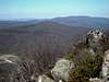
 View of Mary's Rock from near the summit.
Routes
Pass Mountain TrailDirections: Park off route 211, 2.5 miles before the Thornton Gap Entrance to Skyline Drive.
Elevation Gain 1500’
9 miles round trip
Beahms Gap (2485')
MilePost 28.5 off of Skyline Drive. You must cross Skyline Drive to take the Appalachian Trail South.
Elevation Gain 470’
2.5 miles round trip
For both routes
The true summit of Pass Mountain is in the woods at the top of a steep hill. Two rocks are on the side of the trail, and the one on the right is the summit.
 |  |
Red Tape
Shenandoah National Park cost $30 for an annual pass. If you do not live in the DC area, you can pay the $15 fee to enter Skyline Drive. You can hike Pass Mountain from rt. 211 for free. Even though it is in the National Park, payment is only required for Skyline Drive.Watch out for Poison Ivy in the fall.
Camping
There is camping around Pass Mountain at the Pass Mountain Shelter, about a mile south of the summit, on the Pass Mountain Trail. It fits around ten people and has several tent sites as well.In general, campsites are not always open during the winter and spring. Backcountry Camping Permits are required and are available free from park headquarters, visitor centers, and entrance stations. Appalachian Trail hikers may self-register for permits on the AT near Rockfish Gap (south) and Chester Gap (north).
Campfires are not permitted (except at pre-constructed fireplaces at backcountry huts and day-use shelters). Groups may not exceed 10 people. For more info consult the park website.
When To Climb
Climb all year. The park, or sections of the park, may be closed if road conditions are poor. Check with the park at 540-999-3500.Mountain Conditions
Check with the park at 540-999-3500.External Links
- Weather
Weather for Sperryville (nearest town)
- Shenandoah National Park
Shenandoah National Park Homepage