
|
|
Mountain/Rock |
|---|---|
|
|
37.41790°N / 118.6977°W |
|
|
13020 ft / 3968 m |
|
|
Overview
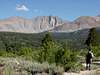
Wheeler Peak is the unofficial name of the highpoint along Wheeler Ridge on the eastern escarpment of the Sierra Nevada. Wheeler Ridge (labeled "Wheeler Crest" on the 15' map) is the impressive 8 mile-long ridge located just west of US395 between Pine Valley Rd and Rock Creek Rd. Like nearby Mt. Tom, it is impossible to miss this fantastic feature as one drives along US395 between Bishop and Mammoth Lakes, yet it sees relatively few visitors. The views from the summit, though not as impressive as those from nearby Mt. Morgan, are unique and worthy in their own right. One has an unusual perspective of Mt. Tom to the south, along with outstanding views of the upper half of the Owens Valley to the north and west.
The eastern slopes of the ridge, steep and fluted, rise more than 6,000ft above the floor of the Owens Valley. Many granite walls, some over 1,000ft high can be found in the gullies and chutes running up this side. The western side of the ridge rises but 2,000ft up from the forested high plateau east of Rock Creek Lake, and offers the easiest access to both the ridge and Wheeler Peak.
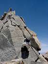
Wheeler Peak has two summits - the northern one is the highpoint (though the 7.5' map makes the southern one appear higher). The ridgeline connecting the two offers some fine scrambling, class 2-4 depending on how strictly one stays along the crest. By its easiest routes, Wheeler Peak is a class 2 climb via either the northeast or southwest ridges.
While Wheeler Peak lies within the John Muir Wilderness, the northern part of Wheeler Ridge along with the high plateau lies outside the Wilderness boundaries. This offers one of the few places in the High Sierra where one can mountain bike at altitudes above 10,000ft on decent, ridable trails (no motor vehicles allowed in this area, thank goodness).
 |  |  |  |  |
Getting There
Wheeler Peak is most easily reached from the Rock Creek area. From US395, take the Rock Creek Rd turnoff and drive 9 miles to Rock Creek Lake. The trailhead is located on the east side of the lake, on a turnoff just before reaching Rock Creek Resort. Take the trail east/northeast, following signs to first Francis Lake, then Tamarack Lakes (though don't actually hike up to Francis Lake). Wheeler Peak will be visible to the east from near the Francis/Tamarack Trail junction.
Alternatively, one can suffer up 6,000ft of scree and other nastiness approaching from the east side of the ridge. In summer this will likely be miserably hot to boot. A true sufferfest in the grandest of traditions.
Red Tape & Mountain Conditions
Wheeler Peak and the surrounding area lies in the John Muir Wilderness. Backcountry permits are required for overnight visits to the area. Permits are free if you pick them up in person at the Ranger Station.
Everything you need to know about conditions, permits and regulations can be found on the Eastern Sierra - Logisitcal Center page.
Mammoth Lakes Ranger Station
White Mountain Ranger Station
798 North Main Street
Bishop, CA 93514
760-873-2500
760-873-2501 (TDD)
When To Climb
Wheeler Peak is normally climbed June-Oct when the access road to Rock Creek is open. As a winter climb, Wheeler Peak offers a more adventurous outing - difficult, but not as hard as Mts. Morgan, Mills, or Abbot. There is a Snow Park located along Rock Creek Rd maintained by Cal Trans during winter months, adding about 4 miles to the distance one must travel to the usual trailheads. Avalanche dangers on both sides of the ridge are real and must be properly assessed before any attempt.
Camping
Overnight camping in the surrounding areas of the John Muir Wilderness is allowed with proper permits (see the Red Tape section). There are plenty of quality spots to be found in the areas west of the ridge, notably at Dorothy Lake and further south at Tamarack Lakes. There are no bivy sites available at the fractured summit.
Etymology
"Probably named for Lt. George Montague Wheeler (1842-1905), engineer and surveyor, head of the army's United States Geolographical Surveys West of the One Hundredth Meridian -- the Wheeler Survey -- from its inception in 1872 until the creation of the US Geological Survey in 1879.
The name was approved as 'Wheeler Ridge' by the BGN in 1911, but appeared as 'Wheeler Crest' on all editions of the Mt. Goddard 30' map and on the Mt. Tom 15' quad. It was not until publication of the 7 1/2-minute quad in 1982 that the name finally became 'Wheeler Ridge' (INF)"
- Peter Browning, Place Names of the Sierra Nevada
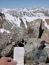
A small register was placed on the highpoint along the ridge in 1979. In it, it is mentioned that a cairn and note dating from the 40's had been found (maybe now at Bancroft Library?), in which the point was referred to as "Wheeler Peak".