
-
 27228 Hits
-
 84.82% Score
-
 19 Votes
|
|
Mountain/Rock |
|---|---|
|
|
42.79170°N / 123.8363°W |
|
|
4319 ft / 1316 m |
|
|
Overview
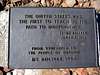
Mt. Bolivar is a modest rocky peak that lies at the northern end of the Klamath Mountains in southwest Oregon. It is just within the northeastern boundary of the beautiful Wild Rogue Wilderness area. For those interested in county high pointing, Bolivar claims the title for Coos County. There is a pleasant trail to the summit that gains 1,160 ft over 1.4 miles. A 360 degree view from the summit stretchs from Mt. Shasta in the south to allegedly Mt. Hood in the north, but I am unable to confirm this from the day I visited. The most impressive views on this one are into the steep valleys and sharp ridges to the south that comprise the Wild Rogue Wilderness area. The summit area once had a lookout, but like many other summits now only cement foundations and remnants remain. Bolivar was named in honor of Simon Bolivar (1783-1830), the Venezuelan-born liberator of Colombia and Peru; Venezuela donated a bronze plaque on the summit in 1984 to commemorate this.
 |  |  |  |  |
Getting There
From I-5 drive 44 miles south of Roseburg, or 22 miles north of Grants Pass to exit 80, Glendale.
Head 2.9 miles into Glendale and turn right onto Brown St., which becomes Reuben Rd. After about 12 miles turn left at a brown signboard on the left. Stay on the paved main road and follow signs for the coast for approximately 15 miles to a six-way junction at Anuktuvuk Saddle. Continue another 3 miles on BLM Kelsay-Mule road 32-8-31 to the obvious trailhead parking area on the left. The road is paved the entire way, in general follow what looks to be the main road. You can continue on Kelsey Mule Rd. all the way to Powers, and access other trailheads in the Wilderness. Very nice scenic road, but very slow going due to the many curves.
Red Tape
As of March of 2005 there are no red tape issues. Bolivar is within the Wild Rogue Wilderness Area, so standard wilderness rules apply. A self-issued wilderness permit maybe required, but the register was empty and neglected in March 05. Bolivar lies in BLM land.
When To Climb
The road may be impassable in the winter; recommended months are May to mid-November.
Camping
There are two primitive campgrounds near the trailhead. Cold Springs near Anuktuvuk Saddle, and Eden Valley Campground. There is room to camp at the trailhead, but there are no facilities.
Mountain Conditions
BLM Medford District
BLM - Medford District: 541-618-2200

2skinners - Nov 4, 2005 3:05 am - Hasn't voted
Untitled CommentI just thought I would let you know that you had an open link under the Miscellaneous section. Have a great day!!