
-
 17747 Hits
-
 84.82% Score
-
 19 Votes
|
|
Mountain/Rock |
|---|---|
|
|
44.02140°N / 114.9748°W |
|
|
10250 ft / 3124 m |
|
|
Overview
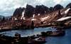
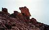
This striking tower sits on the main Sawtooth Crest, .75 miles northeast of Mt. Cramer, and .6 miles southwest of the Finger of Fate. It's located centrally in the Sawtooth Range and is often overlooked by climbers despite solid 5.9 granite climbing. The actual fin formation is so thin that it whistles during a strong wind and requires you to straddle the summit fin. The easiest way up the Arrowhead requires a 5.9 rock climb; a challenging hand crack with a slight overhang at the crux. Along this spectacular ridge in the same vicinity are The Coffin, The Birthday Cake, The Sentry, Red Bluff, and Mt. Sevy. All have rock climbs to their summits and all are not documented yet. One point of interest is that when your straddling the Arrowhead your perfectly in between two major drainage systems (sort of like the Continental Divide for Idaho). To the east is the Salmon River drainage and to the west is the Payette River and Boise River drainages.Here is the only known route:
1) The West face ( 5.9) - One long 180 ' pitch with a 5.9 crux leads to the spectacular fin summit. One rappel to the ridge gulley or two shorter rappels are required to get off. There are some anchor bolts near the top.
The first ascent was by G. Webster and J. Beaupre in 1967. Up until recently, this was considered the one of the hardest free climbs in the range
 |  |  |  |
Getting There
The Arrowhead is located about 14 miles south-southwest of Stanley, Idaho. The peak sits on the main Sawtooth Crest in the central section of the Sawtooths.Road Approach
From Stanley, Idaho take ID-75 south for 12 miles, turn west at Decker Flat, cross the Salmon River and then drive 5 miles on one of the worst 4 wheel drive roads in Idaho. High clearance is required and large boulders need to be negotiated at times.
Hike / Scramble Approach
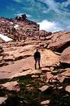
From the trailhead cross Hell Roaring Creek (can be difficult crossing in high water), and hike a relatively flat trail for 1.7 miles until you reach Hell Roaring Lake (Elevation 7407). The main trail goes left here and out toward Imogene Lake. You'll take a climber's trail on the right hand side (north) of the lake until you reach a stream inlet at which the hiking steepens. At mile 3 (from the trailhead), you'll reach a gorgeous unnamed lake at 8179 feet. This destination makes a great bivy spot if needed. From here, follow the drainage that runs SE of the Finger of Fate. You'll stay left (south of this gulley) following a string of spectacular tarn lakes at 9465, 9700, and 9800 feet. The Arrowhead formation should be striking and obvious at this point. You'll aim for the north side of the Arrowhead (left) on the ridge crest, where there's a way over from the east side to the west side. Drop down 50 feet onto the west side and start the climb.
 |  |  |
Red Tape
No permits of any kind are required. No fees or passes are requiredWhen To Climb
Conditions are often windy above 10,000 feet, especially on a major crest like this. Standard climbing season is June through October. Conditions vary greatly. The Sawtooth Valley can be one of the coldest areas in the nation during the winter. Negative readings are often common. Snowfall can vary and occur at any time. Summer days can still be hot, but you'll probably never experience 90 or above, especially once you get up higher.Camping
Camping is allowed virtually anywhere in the regionFor more information go to the Stanley Ranger Station Site
- There are many drive-in camp sites along ID-75 from Stanley southward
- You could camp at the Hell Roaring Trailhead or Hell Roaring Lake
- Good bivy spots could be found at Lakes 8179, 9465, 9700, or 9800
Mountain Conditions
Sawtooth Web Cam can give you a good idea of the conditions in the area:
http://www.ruralnetwork.net/~dpinney/
SNOTEL site gives latest snow depth readings:
http://www.wcc.nrcs.usda.gov/snotel/snotel.pl?sitenum=845&state=id
Google Maps also gives snow depth maps:
http://www.nohrsc.noaa.gov/earth/
Sawtooth Climbing Beta
Sawtooth Climbing Beta is hard to come by. There is no official book or publication that gives detailed description. Here are a few references that have some basic information and photographs:- Climbing Magazine #15
- Rock & Ice #44
- Off Belay Mountain Magazine- #19 (Feb 1975)
- American Alpine Journal- Issue #47 (1973)
Additions and CorrectionsPost an Addition or Correction
samuelstone5 - Apr 5, 2020 5:28 pm - Hasn't voted
3/31/2020 AvalanchePreliminary reports from the Sawtooths indicate that the Arrowhead has come down during the 6.5 avalanche on 3/31/2020 at 5:52pm