
|
|
Mountain/Rock |
|---|---|
|
|
43.79110°N / 116.0907°W |
|
|
7240 ft / 2207 m |
|
|
Overview

Mores Mountain is located on the southwestern edge of the Boise Mountains and in the heart of the Boise Ridge, a 38 mile divide that runs from Highland Valley Summit in the south to Garden Valley in the north. The southern end of the Boise Ridgeline creates the scenic backdrop to Boise, Idaho. Although none of the summits along the ridgeline are spectacular, they offer good hiking and some easy climbing for those in the area.
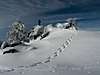
Mores Mountain does not receive as much attention as its some of its neighbors as its southern counterpart, Shafer Butte, blocks views of the peak from the Boise Valley. It is an attractive peak with mostly tree covered slopes and a "bald" summit. The views from the summit are outstanding extending from the West Valley, to the Sawtooth, as well as the best view around of Shafer Butte.
In the summertime, the peak is an easy walk half mile walk from a campground on its south shoulder, allowing those of all ages and abilities to summit. During winter, it is a popular back country ski area and side trip for those playing at nearby Bogus Basin Resort as well as an easy, albeit long, snowshoe.
SP member Sawtooth Sean has done a wonderful job of highlighting the Roadside Rock Climbing Area on the northern slopes of Mores Mountain for those interested in some challenging rock climbing within one hours driving distance from downtown Boise.
The elevation for Mores Mountain is list as 7,237 feet. However, the USGS made a slight mistake as a point on the western side of the summit area reaches the the 7,240' contour line. Therefore, the elevation on this page is listed as that.
 |  |  |  |
Getting There
To access Mores Mountain from the Boise Airport, access Interstate-84 heading west to the junction of Interstate-184 that leads to downtown. The interstate terminates at 13th street downtown. Turn left (north) on 13th and follow it to Hill Road at the base of the foothills. Take Hill Road to a stoplight and junction with Bogus Basin Road. Turn right on Bogus Basin (northeast) and follow the winding, but paved road 16 miles to the Bogus Basin Resort.If attempting in winter, continue past the main base of the mountain shortly until reaching the nordic skiing lodge.
If attempting during summer, follow the road past the main base of the ski mountain for an extra couple miles on a windy and gravel dirt road until coming to campground on the south shoulder of Mores Mountain (none of this is on the USGS topos.)
Red Tape
During winter a 5$ pass is required for snowshoeing along the nordic trails. Please obey all standard snow sports etiquette if utilizing these trails.If attempting from the actual ski resort, prices for day passes run about 45$ per day.
To park at the Shafer Butte picnic area costs $5 in the summer. To avoid the fee drive around to the North side of the peak and follow the trail the crosses the East face of the mountain. It will eventually hook up with the main trail to the summit. This way is more scenic anyway.
When To Climb
This mountain is easily climbed by most during the entire year. If looking for a challenge of any sort, attempt during the winter months. Otherwise, expect a casual walk in the woods for the remainder of the year.Camping
There is a campground located just on the south shoulder of the peak near 6,700'.During winter, staying at a hotel near Boise is recommended or limited lodging is located at the base of the Bogus Basin Ski Resort.
Mountain Conditions
Mores Mountain's conditions can readily be checked year round. The Bogus Basin SNOTEL Site is located just a few miles to the south and operates round the clock. Also, the Bogus Basin Live Webcam will also provide a good idea of what conditions are currently.The following links also provide good information on Mores Mountain and the surrounding areas.