
|
|
Mountain/Rock |
|---|---|
|
|
41.91170°N / 113.3654°W |
|
|
Box Elder |
|
|
Hiking |
|
|
Spring, Summer, Fall |
|
|
9934 ft / 3028 m |
|
|
Overview
Bull Mountain of Box Elder county
Bull-Mountain is the highest mountain of the Raft River Mountain range and is also the highpoint of Box Elder County. This area was pretty much unknown to everyone but the local population but that all changed after the publication of "High in Utah" and "Hiking Utah's Summits", it began to see more and more people seeking it out. The nearest town is called Snowville Utah, a town of 177 folks that is just off I-84. Snowville has a couple gas stations and convenience stores but not much else. Most people stop in Snowville for gas or for a chance to stretch their legs or just motor on past as they head for Salt Lake, just 92 miles further down the road.
There are two ways to get to the top of this mountain, one by a trail and two, by a road. A trail goes up from the Clear Creek campground and for a good trip report on that see the one posted by Moogie (called "a tough tease" at the left. His pictures and description are very helpful as this trail is not an easy one and you best be familiar with what he and Imontop (below) share.
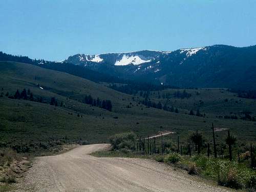
A road goes to within 100 yards of the highpoint which many do drive. However, the Bull Lake Cirque on the north side of the mountain has excellent mountaineering possibilities, including some rock and snow routes according to Scott Patterson. The highpoint of the county is marked by a cairn and a glass bottle register. It is more ideal to do as a hike from the Clear Creek Campground but many of us, myself included, have taken the road up although doing the hike is the best way to savor this mountain.
Well, since I am guilty of using a vehicle to get this summit, let me add it helps to have a 4WD high clearance rig to do the last 7 or 8 miles. Only attempt the road during good conditions, as the road could become treacherous if wet and beware of the tire eating rocks that are encountered on a couple stretches. We ended up with getting one flat on our journey up the road and the next closest place to get a tire fixed is Tremonton, 34 miles east of Snowville. Snowville has no tire fixing service.

driving up but hey, there is a road and my belief is that the majority of folks will drive this mountain instead of hiking it and that choice is up to the individual to make. The summit log bears this out as the majority have driven to the top. However, there are others who will only consider this one
fair game if it is hiked as Scott points out in his comments.
Dunn Benchmark is listed in the linked listing as the 19th highest prominence peak in Utah but in actuality, the Dunn Benchmark area (investigated by Bob and myself) is lower by a few feet than where the cairn and register have been placed.
This topozone map shows where this benchmark is and you pass right by on the road as you head for the top of Bull Mtn. There are some in county highpointing that will do both of the spots in order to lay claim to getting the highest spot on the mountain but from our observation, the Dunn Benchmark is lower and need not be visited unless you want to do so.
Getting There - The Drive
How to get there:A few miles west of Snowville, leave Interstate 84 at Exit 5 in Utah (reset odometer to 0.0), and head west on Utah route 30. At 16 miles, continue straight ahead on Utah 42 (UT-30 is a left turn at this junction). At around 25-26 miles turn left onto signed road 3600 S, also signed for Naf and points west. DeLorme calls this Strevell Road. You leave the pavement here, but it is excellent gravel. In 3.2 miles you'll pass the road leading south to Clear Creek Campground (six miles away)but continue on past this road unless you want to do the hike (see below)The directions from this point on will lead you to the road that heads up to the top of Bull Mtn.
At 35.0 miles from the interstate, turn left (south) onto road 2000 E, then bear right (west) at 36.0 miles onto 3200 S. Pass by a few buildings, and at 37.0 miles turn left (south) again, signed "One Tree G.S." Pass the guard station spur at 41.5 and the signed Dipping Vat Spring, reaching a saddle at 43.0 miles. This is a 4-way intersection, and high clearance will be useful soon.
Turn left (south-southeast) and follow the main track (there are many ATV trails, too, but the main track is obvious) as it heads up the hill. Unfortunately, there don't seem to be road numbers here that match the map, so a map and a good sense of direction are helpful. When you reach the area labeled The Meadows on the topo (47.8 miles) you'll find the mapped road heading northeast is closed and impassable. Keep left just beyond (the right fork goes to George Peak) and soon head up toward the ridge. Bear left at 48.9 and reach the ridge road at 49.0, turning left toward your goal. There are a number of private parcels on the ridge, but the road is a public right-of-way. Continue to mile 51.5 and stroll north to Bull Mountain's summit.(thanks to Ken Jones report for this info)
Coming in from the City of Rocks? No problem:
See this informative trip report for an alternate way in from Idaho's City of Rocks. Heed their recommendations about a good spare tire as we had one go flat near the high point. Lots of sharp rocks waiting to shred your tires if you are not careful. This is a simple day hike with most of the effort being done by your vehicle. No red tape, no campgrounds. Best time for this one is July until October (snow would block road)

The cairn and register
Clear Creek Campground & The Hike
Getting to the campground:From Snowville, UT, take State Route 30 west approximately 18 miles. Bear north at a junction onto State Route 42 for approximately 8.5 miles. Turn west onto a gravel road marked with a small (and easy to miss) sign reading "Strevell Road 3600 South," and follow this road for about 3.2 miles. Turn south at the Clear Creek Campground turnoff, and follow this road for six miles to the campground.
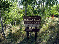

Clear Creek Campground charges no fees; sites are available on a first come, first served basis, and water is available. Buck Tilton in his helpful book, "Hiking Utah" describes the route up from the campground thusly:
"Bull Flat Trail, a path entering the mountains from the north. North is the only safe way to enter this area, "safe" meaning the way to avoid crossing private land and upsetting the ranchers. From the end of the campground, the trail wanders through a lovely forest with lots of aspens and alders, and up to Bull Canyon. After about one mile, a side trail leads off to Bull Flat. Stay on the main trail, (now the Lake Fork Trail) through fir and pine, up to Bull Lake, which is in a surprisingly pretty cirque beneath sheer cliffs. To the west of the lake a faint path leads along a rocky slope to the 9,931 foot summit of Bull Mountain. A long summit ridge of rolling grassland provides panoramic views across barren desert to the Great Salt Lake and on to peaks of Utah, Nevada, and Idaho." He lists it as a 3500 foot elevation gainer with 9 miles round trip.
Recently, SP member Moogie737 did the hike up from the campground and posted a nice TR with helpful pics HERE.
SP member Imontop did this hike and provided the following information about this hike:
Bull Mountain - Lake Fork Route
"Sure you can get to the summit by driving, but this is by far the prettiest way to get there. I followed the route given in the book High in Utah. What a great book. The route starts at the Clear Creek Campground. Turn south and head down the ATV trail until you get to the Lake Fork Drainage junction. There's a nice big sign, so there's no way you can miss it. Turn right onto the trail, and you immediatley start climbing.
Surprisingly, it is very green and lush as you follow the creek up the drainage. I noticed ferns and big leafy plants. Reminds me of the northwest. The trail stays to the left of the creek, but steadily climbs up and over a few little bumps, moving slightly away from the creek. After a mile or so, the trail starts to drop down towards the creek, and crosses it. This is a great place for a small break. I was completely by myself. I actually felt like I was in a wilderness area. Very cool. After the creek crossing, the trail climbs up and away from the creek. At this point, I ran into swarms of butterflies. They were everywhere! I couldn't help but stand there and gauk for a while. At this point, the trail peeters out. There are two choices. You can stay next to the creek, and battle tons of deadfall, and thick bush. Or, you can veer up and to the right and make your way through some very tall sagebrush. I chose the latter and started up the hill through the sagebrush.
It was tough going. The hill wasn't too steep, but the brush was very thick and tall, making it kinda rough. After topping out, things open up some, and you notice a lone pine up ahead. Head for that across the flat, pass it and then you'll plunge into the forest. Just keep picking your way through the pines, aspens, and small clearings. Head in the same general westerly direction. Stay high and to the right of the drainage. To the right you'll notice some cliff bands above you. That's the north ridge of the drainage. Ahead of you, all you can see is forest, but it soon opens up. Once you come out of the last patch of forest, the view will surprise you. I was here on July 4th weekend, and I thought I was in Glacier! As you come out of the trees you'll be entering a beautiful cirque with sheer cliffs and lush and green in the bottom by Bull Lake. This lake is really a marsh. The cliffs had snow hanging off them, and Resevere Point juts out on the southern end of the cirque like a big tooth. It is an absolutely beautiful area!
You'll pick up a trail here again off to your right going up the loose rock. Follow this up to the top and turn to you left, following the edge of the cirque, climbing and turning south at the same time. Through this area, there were deer-beds everywhere, and I scared two or three of them up. Once on top you'll be able to look back down the drainage you came up. This is the top of the Raft River Mountains, and it is very flat. You notice all kinds of roads crisscrossing each other, and you'll have to cross a barb wire fence. The summit is not recognizable, and you'll need a GPS to find the high point.
I'm still not sure if I bagged it. Didn't have a GPS. Anyway, I continued on around the top of the cirque onto Rosevere Point and had lunch. Along the way, I found a coyote den. No pups , but lots o' poop! I was very surprised at the amount of wildflowers that covered the grassland on top. For my return trip, I went back down the way I came up. But, I'm sure it would be an interesting trip by going down the Resevere drainage. All together, it was a 7 hr trip, but I beleive it was only that long, due to the route finding and bushwacking. But what a great area to be in! Like I said, I was solo all day. And one other thing to note. Check yourself for ticks when you get done. I found three!"
Posted Mar 9, 2006 2:49 am
In regarding the highpoint, it is marked with a cairn and has a register as these pictures show.
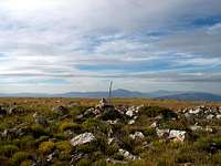
The summit area

Register
Red Tape
No red tape or permit needed at this time. For more information aboutthe campground and area conditions, contact:
Sawtooth National Forest,
Burley Ranger Station,
3650 South Overland Avenue,
Burley, ID 83318; (208) 678-0430.
Weather
Add Camping text here.Weather at nearby Snowville

More information
Michael Kelsey, has a full page of information on Bull Mtn including a bit on how to do this peak in the winter time.Utah Mountaineering

A good overview of the Bull Mtn area
The county highpointing Utah page has some helpful trip reports posted there and you can access that information by clicking HERE.
Box Elder County
Here is some information about the county itself. From Wikipedia I quote:" It lies on the north end of the Great Salt Lake, covering a large area north to the Idaho border and west to the Nevada border. Included in this area are large tracts of barren desert, contrasted by high, forested mountains. The Wasatch Front lies along the south-eastern border, where the main cities are found. As of the 2000 Census, the population was 42,745, a small increase over the 1990 figure of 36,485. By 2005 it had reached an estimated population of 46,440. It was named for the box elder trees with which the county abounds. Its county seat and largest city is Brigham City.
Box Elder County in Northwestern Utah is the state's third-largest county in size. It has a population of 42,000 people with its county seat in Brigham City. It is well-known for its wonderful peaches and apples. It is also the county in which two pivotal pioneering efforts took place just seven miles apart.The nation's first transcontinental railroad came to completion at Promontory Point (30 miles west of Brigham City) in 1869. Less than 100 years later, in 1959, a first-stage Minuteman missile motor was test-fired seven miles east of Promontory by the Thiokol Chemical Co., as it was then known. That motor was the forerunner for the rocket boosters that today power the Trident and Peacekeeper missiles and NASA's space shuttles. From the train age to the space age in one county.
Tracy - Feb 10, 2013 1:34 am - Voted 10/10
suggested elevation correctionDean, Since Dunn Benchmark is listed on the USGS topo map as 9,925 feet in elevation and since Bull Mountain is widely accepted as being higher than Dunn Benchmark, I would suggest using the elevation listed in the guidebook, "High In Utah" as the corrected elevation for this peak page. Instead of using the contour elevation of 9,920 feet, the highpoint elevation should be 9,934 feet. Tracy
JS82 - Feb 23, 2023 7:21 am - Hasn't voted
Bull Mtn is on Private LandJust as an FYI, Bull Mountain and the cirque are on private land (though the road behind the cirque is an easement). The owner let us know that they're happy to have anyone who wants to visit to do so, but asked that vehicles stay on the established roads and that no one climb or ski / snowboard there without permission. He told us they they were climbing themselves one day when someone pushed rocks off the cliff likely for fun, and it came close to hitting one of their party. He said feel free to hike the property and drive on the established roads, but to please be respectful.