
|
|
Mountain/Rock |
|---|---|
|
|
44.20048°N / 74.59743°W |
|
|
Hiking |
|
|
Spring, Summer, Fall, Winter |
|
|
2539 ft / 774 m |
|
|
Overview
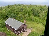
Mt. Arab is a short but very worthwhile hike in the Adirondacks. At 1 mile long and 760 ft vertical gain, with an easy/moderate trail, this makes a nice family hike also. There is a fire tower at the top that provides excellent views of the surrounding areas and a small sometimes unmanned ranger station. Southwest of the summit, there is another rocky, open area with a bench.
While at the summit in July 2006, there was a military jet that actually flew below us. However, only the 2 guys up on the tower at the time got to see it. They said it was amazing, which I no doubt believe. Not very often you get to view a short airshow from above!
Getting There
From Tupper Lake, NY, drive west on Rt 3 for 6 miles and you'll see a sign for Mt Arab. Turn left at the sign onto Co Rd 62 and go 1.7 miles to Mt Arab Rd on the left. Drive 0.8 miles down Mt Arab Rd where you'll find the parking area, which is just around the corner past the railroad tracks and well marked.
Red Tape
No red tape here. There is a trail register and usually some interpretive maps also.
Camping
Mt. Arab is a short hike and in no way requires any camping. However, there are many campgrounds around this area from which to choose.
External Links
Friends of Mt Arab Page - A lot of information on Mt Arab can be found at this link including the history of the fire tower.