
|
|
Mountain/Rock |
|---|---|
|
|
47.49508°N / 123.50434°W |
|
|
Grays Harbor & Mason |
|
|
Hiking |
|
|
Spring, Summer, Fall |
|
|
4949 ft / 1508 m |
|
|
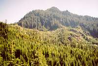
Overview
“Wyvern Peak” sounds like a great name for a mountain. But it’s not the name of this mountain. Ok, how many submissions on summitpost begin with “w-y”? I count three: two route pages for the Wy’east Glacier on Mt. Hood and one mountain page for a Wyoming Mountain. Okay, well three now as of today, August 30, 2006.What is the significance of Wynoochee Point? It happens to be very near to the Grays Harbor-Mason county line in the southern Olympic Range. Pt. 4949 is properly designated as "Wynoochee Point". It only has 349 feet of prominence so doesn’t quite qualify for “peak” status by Washington’s 400P standard, but it does have enough individuality on the east-west divide that connects it with higher Capitol Peak (5054F, 1494P). Some have called Pt. 4949 the west summit of Capitol. To me the distance between the two points seemed too far for this attachment.
There are several crags on the east-west ridge. Just west of Wynoochee Point (Pt. 4949), at about 200 yards distance, the north-south county line crosses over the ridge. Due to modern GPS capabilities, it is now possible to guess with reasonable accuracy where exactly on this crest this crossing is located (how accurate is the topo map with respect to the county line, anyway?). With this assessment in hand, it has been surmised that the county line cuts over the ridge right at a small saddle thus making the first short crag west of this saddle the highest point of Grays Harbor County. The USGS map shows a small 4880+ bump near there. There are actually a series of crags near this bump and they all get lower in elevation as you proceed westward so the first one might as well be the county highpoint. There is a cairn atop this crag and inside the cairn is a plastic jar register. There was a register on Pt. 4949 too but the booklet inside had completely turned to pulp so I took it and the ineffective PVC canister down the mountain and threw them in the trash.
Wynoochee Point offers fine views of the southern Olympics, including a distant Mount Olympus. But, strangely, the views of Capitol Peak only half-a-mile to the east are obscured by trees and high shoulders.
There are 39 counties in Washington. The highpoint near Wynoochee Point ranks as the 25th-highest among these (list). It should be noted that, upon close inspection, this county highpoint is not really a “liner” (a highpoint that occurs right on the county line, meaning there is higher ground immediately into the neighboring county) because there is a rise of one 40-ft contour just west of the line. This county highpoint thus has a "dirty-rule" prominence of 40 feet (but still "clean rule" prominence of zero feet) making it the 37th-most prominent Washington county. The true prominence if you were to survey the rise of the crag from the saddle on its east would be approximately 15 feet. The two true liners in the state (hence zero prominence) are that of Clark County (“Sturgeon Fin") and Skamania County (”Skamania Pinnacle").
The name Wynoochee is associated with the river of that name flowing in the valley on the west. Wynoochee Lake to the southwest is large and is a popular destination for the locals. The standard approach to the cohp goes past this lake.
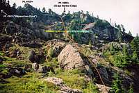
 Wynoochee Point from west
 Wynoochee River Valley
Vehicle Approach
The only really worthwhile approach for Wynoochee Point is via Wynoochee Valley Road to the SSW. This road can be accessed from US Highway 12.There are two initial approaches from that highway.
The one farther east goes up the Satsop River valley taking either the East Satsop Road or Middle Satsop Road as they proceed north from the little town of Satsop. For the former, it is necessary to jog left (west) at Schafer State Park to get onto Shelton-Matlock Road (this is also the road one wants to get on if coming from Middle Satsop Road). Boundary Road forks left at about 2.5 miles from the state park. In about 4 more miles turn left (west) on Cougar Smith Road. This road is initially paved. In about 5 miles reach Wynoochee Valley Road and turn right (north), following it to its end (or to the Copper Creek washout immediately west of the county highpoint).
The approach farther west on Hwy 12 is about a mile west of Montesano. This road is immediately known as Wynoochee Valley Road so you will have no turns to worry about but it’s probably a few miles longer if coming from the east (from the Puget Sound, for example). Wynoochee Valley Road is paved for the first 12-15 miles to where it meets Cougar Smith Road.
From there on the road is gravel but in excellent shape with only the minimum of potholes. From the junction with Cougar Smith Road drive Wynoochee Valley Road for over 10 miles. You will go past Wynoochee Lake but it is not really visible from the road. At 13 miles you will reach the junction where I believe the winter game closure gate is located. Stay right at this junction and continue for 4.1 miles to the washout at Copper Creek (elev. 1640 ft). The now-defunct Wynoochee Falls Campground will be passed at 1.9 miles from the end. In about 0.3 miles from the washout there is a bridge across the river on the left.
Bike/Hike Approach
Hike or haul bikes around the huge washout (there is a good path on the downhill side of the road below the giant corrugated pipe).On the other side of the washout are two roads leading north. BE SURE TO TAKE THE UPPER ONE GOING UPHILL or you'll end up wasting your time like Dennis.
The initial mile of road is getting overgrown but is still largely bikable (on the downhill) except for a couple minor trees blocking. The road climbs 700 ft to a switchback. Just after the switchback the road improves in terms of brush but deteriorates in terms of bedding. The road becomes rocky and it is actually more of a pain in the wrists and triceps than the brushy part. In 1.7 miles from the washout the road rounds the corner above Copper Creek and offers the first views of your destination still 2,000 ft above you to the east. At 3,020 ft go left at the junction. The road initially goes away from your destination but it soon curves back around. At 2.6 miles from the washout reach the pass (c. 3,500 ft) immediately NW of your destination. This pass is informally known as Copper Creek Pass.
 Wynoochee Point from northwest
Final Ascent
From Copper Creek Pass (3,500 ft) there are really two options to continue to the summit. I did the first of these. The second is just conjecture.From the pass where the road junction is go right a few paces then climb up a small gravel berm (a raised, rounded knoll) right at the junction. On the crest of this knoll is a manageable path through chest-high salmonberry that leads southeast for about 100 feet to the lower terminus of Pt. 4949’s NW Ridge. Fight your way through a small barrier of tight evergreens then onto more open, but steepening terrain. Climb straight up the ridge, veering left and right where necessary to avoid windfall. Some of your veering will be pronounced. At some point around 3,800 ft it will be necessary to go all the way left to the sharp ridge arête to get over the rock wall on its right (some brachiation through here). This will put you on a small bump. Downclimb its other side to a small basin/brushy area (approx. 4,000 ft). A rock wall now bars continued efficient climbing along the ridge. Instead, diagonal up and right on a faint ramp eventually into trees. The rock wall will end eventually and allow for a step upward then back left for several hundred feet to where another short rock wall will be encountered. A fortuitous ramp/slot allowed an easy climb up this wall (I think it was a game trail). This will dump you out at the base of a talus/boulder area with high, reddish rock towers on the left. These are the close contours at 4,300 ft on the NW Ridge. Climb up the talus then rightward through a few game slots to the upper parkland area that begins at about 4,500 ft. Continue per two paragraphs from now…
Another option is to go right all the way to the end of the spur that goes across the WNW slope. It ends in about 0.4 miles. From the end of the road or just before its end go left into the steep trees (expect slabs and mossy boulders amid forested areas) turning sharply left (north) at around 4,000 ft to a minor open area of grass at about 4,100 ft (I saw this open area from my route along the NW ridge). Turn back right (east) and take the path of least resistance up to the open, parkland-like area that starts at about 4,500 ft. Continue per next paragraph…
This parkland is low brush and grass interspersed with slabs and minor stream courses. Keep going up to the upper park basin (approx. 4,700 ft). At this point there will be (if it’s not a whiteout) three major crag sections above. The one to the far left is Pt. 4949; the one at center is Pt. 4920+ (it is lower than Pt. 4949 but looks higher from below); the county highpoint crag is to the right (leftmost-small tower of that set).
The terrain below the crags looks easier from below than it is. To access the county highpoint, scramble up to it as best as possible through and past and over slabs and small drop-offs to the small notch just left (east) of the cairned highpoint crag. A short Class 3 step is required to get on the north pedestal of the crag. Circle around it counterclockwise (past a small, white snag) then up to the flat top and cairn.
It is not possible to scramble the crest eastward all the way to Pt. 4949 without being blocked by a drop-off at the center crag. I downclimbed the north side to get around it. A south side bypass might also be feasible. Once at the notch between center crag and eastern crag (Pt. 4949), scramble up to the top (some mossy Class 3).
All in all the route is Class 3 with plenty of steep places to fall and hurt or kill one’s self if not careful. Allow 60-90 minutes to go from the pass to the summit crags (1,400 ft of gain). Allow 15 minutes to make the traverse between the crags. Allow 30-45 minutes to descend back to the pass depending on how well you paid attention to your up-route.
 Upper northwest side
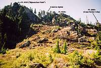 Wynoochee Point from north
 Looking down at the Cohp
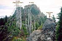 At the Cohp
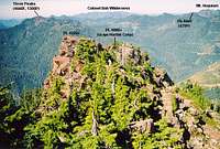 View west from Wynoochee
When to Climb
One could conceivably climb this peak at any time of year but in the snowy season you’ll want an ice axe and perhaps technical gear. The best time would be to wait until May. The season would last until the first significant snows of autumn block reasonable access. Of further consideration is the seasonal closure of the upper Wynoochee River Road from Octbober 1 to April 30. The gate for this closure is about four miles short of the normal stopping point (the washout at Copper Creek). In early season (May) you can make use of snow to boot up the steep snow to the summit area. But snow may very well still cover the approach road, making biking it problematic. In late season the snow will be all gone. In its place you can look forward to steep, slippery duff and wet, slippery foliage if it should happen to be raining or damp.Essential Gear
Early SeasonBicycle, ice axe, possible crampons if cold, possible snowshoes if mushy, possible technical gear.
Summer Season
Bicycle, extra water (there is none above about 3,000 ft in late summer)
Red Tape
There is a seasonal wildlife closure about 4 miles before the Copper Creek washout parking point. The gate is closed from October 1 to April 30.Camping
Wynoochee Falls Campground a few miles before the washout has been decommissioned and the entry road has been back bermed. However, there does appear to be camping at the end of the road (at the washout) but it may not be flat enough for your sleeping comfort. The best place to camp near the washout would be at a short spur on the left about 400 yards short of the washout. This spur is just after the junction with the road going left across the river (over a bridge). The spur leads down to the river and the gravel bar there.External Links
Trip Reports on www.cohp.orgDr. Roper's page on the county highpoints of Washington
ericnoel - Nov 14, 2008 7:45 pm - Voted 10/10
Grays Harbor COHPHi Paul, Two updates for this page: The washout at Copper Creek was fixed as of May 2008. However, this doesn't really help much as the road is so overgrown as to be undriveable just past that creek anyway. But you'd have to think that if the USFS went to the expense of fixing the road that it has to be to allow for future logging which raises the possibility that there may be additional improvements in the works for the road above that point. Also, the text in paragraph #6 refers to Gibson as the Grays Harbor COGPP which we now know is not the case.
Redwic - May 18, 2010 12:58 am - Hasn't voted
Road Paving Project (2010)As of May 2010, Wynoochee Valley Road, which turns into Forest Road 22, is paved for its first 27.6 miles to a small bridge crossing over Save Creek. In addition, thanks to the American Recovery and Reinvestment Act of 2009, Forest Road 22 is in the process of having a five-mile stretch paved between Save Creek and Forest Road 2284. In other words, soon most of the drive to the hiking starting point will be paved (not that a little gravel road travel ever stopped county highpointers). However, during the road paving project, access to Forest Road 22 beyond Cougar Smith Road (18 miles from the start of Wynoochee Valley Road near Montesano) will be closed Tuesdays through Thursdays every week. People can monitor the progress of the road paving project here.