

|
|
Mountain/Rock |
|---|---|
|
|
47.45874°N / 120.93201°W |
|
|
Hiking |
|
|
Spring, Summer |
|
|
6878 ft / 2096 m |
|
|
Overview

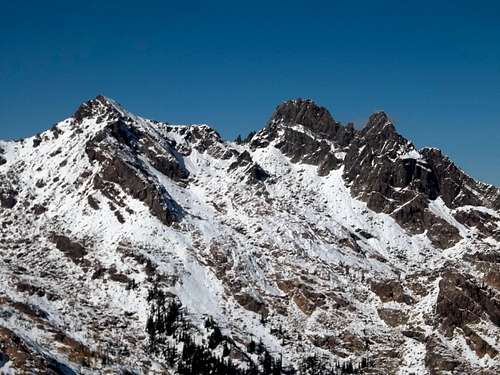
Not Hinkhouse Peak as it is unofficial called is an another beautiful gem in the Teanaway Region. Though this summit is roughly the same scale as many peaks in the region, it unique location, being just far enough from other peaks such as Esmeralda, Mount Stuart and Teanaway Peak give this peak excellent views of the whole Teanaway Region as well as the south sharp face of the Enchantments Region. Closeup views of peaks as Mount Stuart and Esmeralda and distant views of Mount Rainier and Glacier Peak make this mountain a very special summit to attain.
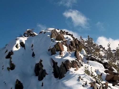
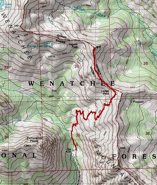
There are two ways to reach the summit of "Not Hinkhouse Peak". The first way by Longs Pass is the easier and more popular way to this summit. At 8 miles roundtrip, 3000 feet of elevation and being for the most part nothing more than an offtrail walkup on this side, this summit can be attain by the average climber and experienced hiker without dramatic issues. At worst this might have one or two spots of Class 2. The key is to follow the trail all the way to the top of Longs Pass. Once on the ridgeline make a left on the ridge and follow the ridge as it first rises than drop that rises again much more steeply to the summit. With a good base of snow this summit can be attain rather easily. This ridge does cornice easily though those use caution when on cornices.
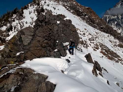

The other way up is from Ingalls Pass which is again 8 miles and 3000 feet of elevation gain. This route is not recommended in wet or icy conditions due to the fact that there are a number of areas that can cliff out. If carefully manuvered it is said that it can be Class 2. Hopefully I can go back here in summer conditions to verify this. However my experience is that this route is Class 3 and unless you have great snow or a perfectly clear day with no summer snow it is not recommended. The only plus here is that if you do the route in fall you will get the see the beautiful larch from Ingalls Pass.
"Why NOT?" Hinkhouse Peak
The most recent edition of Beckey's Cascade Alpine Guide: Columbia River to Stevens Pass erroneously identifies as Hinkhouse Peak the highest point on the ridge between Longs Pass and Ingalls Pass in the Teanaway/Mt. Stuart area. The effort to have a peak officially named to commemorate Jim Hinkhouse originally applied for that peak to be so named. However that application was withdrawn at the request of the Washington State Board on Geographic Names.The summit in question is situated on the boundary of the Alpine Lakes Wilderness. The Board had previous experience trying to establish new names in designated wilderness areas, and found that the US Board on Geographic Names policy against granting names in such areas probably applied to features on wilderness boundaries as well. Evidently the editors of the Beckey guide made their entry on the basis of the original application, not realizing that the applicants were working with the Board to identify the peak in the North Cascades that was eventually approved.
We have written to Mr. Beckey and The Mountaineers explaining the situation and the circumstances surrounding the misunderstanding. Presumably the error will be corrected in any future edition of the guide.
Map of the Route
Getting There

From Seattle, take I-90 east to Exit 85 near Cle Elum. Follow State Route 970 toward Wenatchee for about 7 miles, then turn left onto Teanaway Road. After 7.3 miles the pavement ends at a fork, take the road to the right, North Fork Teanaway Road, which runs another 15.4 miles to its termination at the Esmeralda Trailhead.
Park at the trailhead (forest pass required) and take the Esmeralda/Longs Pass trail for about .5 miles to an intersection. Follow the trail to the right up switchbacks to the Long's Pass intersection. Take the left trail to Ingalls Pass, an elevation of 6,500 feet.
From the pass you can see Ingalls Peak to the northwest, Mount Stuart to the northeast. Follow the ridge west to Point 6878, which the Beckey guide incorrectly identifies as "Hinkhouse Peak". The views are even better from this point. The Esmeralda Peaks are to the southwest.
Red Tape - Camping
You'll need a forest pass to park at the trailhead. The peak is located on the boundary of the Alpine Lakes Wilderness Area. There are some nice camps in the basin toward Ingalls Peak, north of Ingalls Pass, but camping is not allowed at Ingalls Lake.So Where is Hinkhouse Peak?
Petitioners seeking to name a peak in Washington to honor Jim Hinkhouse worked with the staff of the Washington State Board on Geographic Names to identify a worthy mountain. Ultimately a peak near Washington Pass in the North Cascades was officially designated Hinkhouse Peak.External Links
Quick photo TR of this special mountainThis is a more detailed TR of this mountain