
-
 13896 Hits
-
 87.31% Score
-
 24 Votes
|
|
Mountain/Rock |
|---|---|
|
|
34.37100°N / 118.071°W |
|
|
Los Angeles |
|
|
Hiking |
|
|
Spring, Summer, Fall, Winter |
|
|
6600 ft / 2012 m |
|
|
Overview
Granite Mountain is the highpoint on a popular loop trail connecting Iron Mountain, Round Top, Granite, and Rabbit Peak. None of these peaks of themselves (all have roads that come within a couple hundred feet of the summit, and Round Top has a road all the way up) are particularly challenging, but the loop connecting them is an enjoyable and scenic outing, requiring about a half day for an average hiker. For those who are interested in such things, all four peaks are on the Sierra Club's HPS peak list.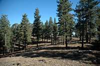 The open, park-like summit area of Granite Mountain
The summit of Granite Peak is an flat, open wooded area, from which it is difficult to see much. But if you are doing the loop, there are views aplenty. To the south are Condor Peak, Fox Peak, Mount Lukens, Josephine Peak, Strawberry Peak, Mount Wilson, San Gabriel Peak, and Disappointment Peak. To the west is Mount Gleason, another drive-up that is popular with star gazers and amateur astonomers (it is a good place to watch meteor showers). To the east are Pacifico Mountain, the peaks of Pleasant View Ridge, Mount Waterman, Twin Peaks, and others.
The peak takes its name from the granite outcroppings on the summit area.
Getting There
From south of the San Gabriels you will need to find your way to I-210. If coming from the east, exit at Lowell, pass under the freeway and continue on up to Foothill Blvd. Turn left. After a few miles touring the lovely Sunland/Tujunga area you will come to Mt. Gleason Road. Turn right. Follow Mt. Gleason Road to its end at Big Tujunga Canyon Road. Turn right. Go 16.5 miles, first on Big Tujunga, then continuing on Angeles Forest Highway to the Monte Cristo campground 1.2 miles past the junction with Upper Tujunga Canyon Road. As you enter the campground the road splits into a one-way loop. Drive through the campground. Just before the road crosses a stream and heads back out to the highway there will be a dirt road on your right. If you have a low-clearance vehicle you will want to park here and walk. Four wheel drive is not needed for the first segment of the road, but a little bit of clearance wouldn't hurt. Subies should do just fine. Follow the road up canyon to where another road comes in from the right. There is parking for a couple of cars here. There are also spots up either arm of the 'Y', but they are limited. The right-hand fork gets steep and sandy.From the west, exit I-210 at Sunland Blvd. Head east (Sunland will turn into Foothill Blvd.) for about a mile and a half to Mt. Gleason Road. Follow directions above from this point.
If you're coming from the north (i.e., Antelope Valley), exit Highway 14 a few miles south of Palmdale at the Angeles Forest Highway exit. Take Angeles Forest until you get reach Monte Cristo campground, and follow the directions above.
Routes
| Route | Distance/gain | Description/Comments |
|---|---|---|
Iron/Roundtop/Granite/Rabbit Loop 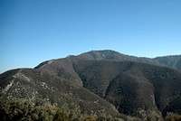 |
~8 mi R/T, 3,800' gain | This trail can be done in either direction, although heading up Iron Mountain first will get you into steeper cross-country travel (think sand). If heading up Rabbit Peak first, take the left-hand branch at the 'Y', and follow the road up (less than a mile) to where it crosses the south ridge of Rabbit Peak. Find a way up the steep road cut and through some ugly brush (~100 feet). Gain the very crest of the ridge as soon as possible, because it gets much better once you do. A use trail winds its way up the ridge, over the top of Rabbit Peak, down to a saddle, then up to Granite Mountain. The register is in a group of rocks on the south end of the flat summit area. Drop 300 feet down the east/southeast flank of the mountain to a dirt road. Follow this south to the summit of Roundtop. From Roundtop head west down a ridge, again following a use trail until you reach a saddle just below the summit of Iron Mountain. Tag the summit of Iron (10 minutes from the saddle) then return to the saddle and find a use trail that weaves through the chaparral about 100 feet west to another dirt road. Turn right (north) on the road and walk about a mile back to the 'Y' intersection. |
| From Forest Road 3N90 | ~1/2 mi R/T, 300' gain | Forest Road 3N90 is the road that passes just east of the summit. The Sierra Club Hundred Peaks Section provides driving directions here |
Red Tape
Granite Mountain lies within the Angeles National Forest . A National Forest Adventure Pass or Golden Eagle pass is required to park in the ANF. Annual passes are $30, and day passes are $5. Passes can be purchased at Forest Service offices and virtually any sporting goods store in Southern California. No permits are required for hiking or camping.Camping
Monte Cristo Campground is a nice, shaded place with pit toilets. It's quite popular. There aren't too many other campgrounds nearby, but you can check the ANF web site for additional possibilities.When to Climb
Unless you are simply driving up, Granite Mountain is probably best climbed fall through spring; summer days can be blazing hot. There is no water anywhere on the loop trail.Weather forecasts for Mount Wilson, which lies a few miles to the east, are easily obtainable in Southern California newspapers and on line. Mount Wilson conditions are a good proxy for Granite Mountain.
Ticks, Poison Oak, and Hunters
Two hazards you may encounter on the trail:Ticks are out mostly in the moist cooler months, especially in the spring. Avoid brushing against grass and branches along side the trail. Ticks will cling onto your skin and clothing. Check frequently for these slow moving parasites.
Poison Oak is plentiful in riparian areas, know what it looks like and don't touch it.
I won't call them a hazard, since the deer hunters I've run into in the area seem pretty level-headed, but it's worth staying alert and dressing conspicuously during deer season.