
|
|
Mountain/Rock |
|---|---|
|
|
45.00298°N / 70.33327°W |
|
|
Hiking |
|
|
Spring, Summer, Fall, Winter |
|
|
4010 ft / 1222 m |
|
|
Overview
There are only 14 peaks in Maine that qualify as 4000-footers (under AMC rules), and some of them are on the list only by the skin of their teeth. Spaulding Mountain, sometimes called Spalding Mountain, is one of the latter, and wasn't even on the list until 1998. You can still find sources which give the height of Spaulding Mountain as 3998 feet, and the "new" height of 4010 feet is only an estimate (last contour plus half the contour interval), but USGS maps do show the summit lying above the 4000-foot line.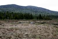
Spaulding from Caribou Pond
Aside from barely scratching the magic elevation, Spaulding is distinctly unimpressive. Its summit is in the trees, though short side trails lead to good views to Spaulding's larger neighbors: Sugarloaf, Crocker, Abraham, Bigelow, and Saddleback (and also to Redington, another runt among 4000-footers).
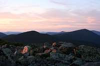
(I hiked up on an intermittently rainy day; photos of distant peaks came out terrible. But I saw those same mountains from other points nearby, and they're worth seeing.)
Note that the maps provided by online services such as Topozone are not entirely accurate in details such as the locations of trails. The maps included in the Maine Mountain Guide published by the AMC can be relied on to be better. (The maps are also available separately.) Hikers who frequent Maine have also recommended the Delorme Atlas.
Getting There
Spaulding & Sugarloaf
The nearest town is Carabasset Valley, which might not show up on your map, though the ski resort at Sugarloaf will be marked on most road maps. For online map searches, try looking for Kingfield, a few miles south of Sugarloaf along Maine Route 27 at its intersection with Maine Route 142.
To get there from points south, take Interstate 95 to Augusta, Maine. From there, follow Route 27 (several turns, watch for signs) a total of sixty miles to reach Kingfield. Continue north about fifteen miles to the huge sign for the Sugarloaf ski resort. See "Trailheads" section for further directions depending on chosen approach.
Trails Overview
The summit is on a short (150m) spur trail. This spur is blazed in blue and there's a small sign, courtesy of the Maine Appalachian Trail Club. From the summit cairn a couple of sub-spurs lead to better views a few steps away.
A.T. on Spaulding
The only other maintained trail on this mountain is the Appalachian Trail (A.T.). It is very well-maintained, and marked with white blazes. From the Sugarloaf summit spur, south to the Spaulding summit spur is about two miles with about eight hundred feet of elevation gain.
Of course, first you have to climb (most of) Sugarloaf, either by the A.T. from Caribou Valley Road (C.V.R.) or via the ski slopes. Either way you're looking at an additional two miles, but the additional elevation gain varies: about 1500 feet on the A.T. without detour to Sugarloaf summit; about 2000 feet on the A.T. with detour, or about 2500 feet from the base of the ski slopes. (One-way total: 4 mi, 2300-3300 ft gain)
If you're taking the A.T. to reach Sugarloaf, you have a choice of trailheads: the hard-to-reach and hard-to-find trail crossing on Caribou Valley Road, or the navigation-friendly crossing on Route 27.
The latter means you'll have to climb and descend Crocker Mountain before you even get to Sugarloaf. Add a further six miles and at least 2800 feet of gain. (One-way total: 10 mi, 5100 ft of gain [5600 with Sugarloaf spur].)
Finally, you could take the A.T. northbound from Saddleback Mountain. (one-way total 12+ miles, 5500+ ft gain)
Trailheads
sugarloaf ski slopes (to A.T. southbound)
The ski slopes provide a foolproof shortcut to the Appalachian trail (via a spur trail from the summit). Outside of ski season, parking is ample and trouble-free (if you avoid a few reserved lots). Hiking up the slopes during ski season is dangerous and rude, and might get you into trouble. Try contacting the Sugarloaf ski resort in advance.
Route 27 (to A.T. southbound)
Follow route 27 about three miles North past the Sugarloaf entrance, and keep your eyes peeled for a small brown sign bearing a hiker logo. There's a small parking lot (free).
Caribou Valley Road (to A.T. southbound)
Caribou Valley Road (a.k.a. Caribou Pond Road) heads south from route 27 halfway between the Sugarloaf entrance and the A.T. crossing, at the height of land and almost opposite the sign for "carabasset valley transfer station". The A.T. crosses this road about 4.5 miles down. UPDATE summer 2016: I'm told there is now a locked gate across Caribou Valley Road, about half a mile before the A.T., just before a rotting metal bridge. There is room for a few cars to park at the gate.

road hazard
Saddleback ski area (to A.T. northbound)
When you reach Farmington Maine (on route 27 about halfway between Augusta and Kingsfield), turn left on Route 4. At Rangeley, Maine, just before the intersection with route 16, turn right at the sign for Saddleback ski area.
From the top of the Saddleback ski lifts it's at least ten miles as the crow flies, north along the A.T. to Spaulding Mountain.
For an even longer hike that avoids the ski slopes, the A.T. intersects Route 4 near Sandy River Ponds (about five miles past the village of Madrid on Route 4 northbound, ie 32 miles from Farmington). There's a parking lot at the crossing.
Red Tape
Essentially none. No hunting on Sugarloaf land. I think Spaulding is on land belonging to Plum Creek Timber company, which has long allowed recreational uses. A sign near Caribou Pond said a permit was required for fires in that particular spot, but I don't know where to apply for a permit.Starting about a mile west-southwest of Caribou Pond is a U.S. Navy training ground (used for practicing "escape and evasion", I assume mostly by pilots). In principle hikers are not welcome. (In practice enforcement is reported to be "erratic".)
Camping
With the A.T. as the only maintained route, there are only two maintained spots to sleep:Spaulding Mountain lean-to

Spaulding Mtn Lean-To
Crocker Cirque Campsite
Located on the A.T. low on the eastern flank of Crocker (less than a mile west of Caribou Valley Road).
In an emergency, shelter may be available in the ski lodge on the summit of Sugarloaf: the door is left unlocked, even in the off season. (I don't know about overnight in the winter, though.)
When to Climb
Year-round, but it is more difficult in winter.Thanks to the ski resort, Route 27 should get plenty of prompt snowplow service.
Signs on Caribou Valley Road say "no snowmobiles allowed on this plowed road", but online sources indicate it is usually not plowed and snowmobiles do use it. Even if it were plowed, parking would be nonexistent.
I don't know whether the A.T. trailhead parking on route 27 is plowed in winter or not.
The Sugarloaf parking lot is, of course, always plowed, but I don't recommend hiking up the ski slopes during ski season.
Spaulding is covered in dense fir and spruce, casting shade where snow can linger into June. Bring snowshoes until the end of May.
I found several shotgun shells near Caribou Valley Road; be especially cautious in the fall (deer season).
Weather
Weather on top of Spaulding Mountain will not be vastly different from the weather in nearby valleys.
technicolorNH - Jun 10, 2016 12:36 am - Hasn't voted
Access from the CVRThe Caribou Valley Road is now gated one half mile from the Appalachian Trail crossing. The metal grate bridge just beyond it has decayed enough that the owners of the road have decided to bar entry beyond it although be aware that at least one wooden bridge on the way in was looking pretty rough as well. Still passable as of this writing but as Nartreb said, check the bridges on foot BEFORE crossing them, particularly if it has been some time since I wrote this comment. There is a parking area off to the side just before the gate sufficient for four vehicles at least, with enough space to park on the road in many places. Someone installed a board bridge at the stream crossing, which makes the initial water crossing much easier.
nartreb - Jun 21, 2016 1:00 pm - Hasn't voted
Re: Access from the CVRThanks, I've updated the page.