
-
 8759 Hits
-
 86.37% Score
-
 22 Votes
|
|
Mountain/Rock |
|---|---|
|
|
34.37120°N / 117.936°W |
|
|
Los Angeles |
|
|
Hiking |
|
|
Spring, Summer, Fall, Winter |
|
|
7003 ft / 2135 m |
|
|
Overview
Winston Ridge is a high point on a ridge by the same name in the high country of the San Gabriel Mountains. The ridge on which this peak is located bears the name of a Pasadena banker who lost his life in a blizzard while on a hunting trip at the turn of the previous century. In the 1890’s, it is said that deer and bear were plentiful in Cooper Canyon, to the east of Winston Ridge. Mr. Winston’s frozen remains were discovered in 1900 on the neighboring ridge, whose high point was named Winston Peak. The name was later extended to the ridge on which this peak is located.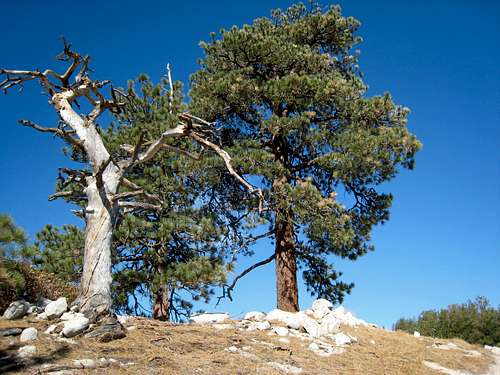 View along Winston Ridge 7.28.07
Winston Ridge is strategically situated so as to allow views both of the San Gabriel front range to the southwest and of the desert area to the north. Beautiful Pleasant View Ridge appears across the drainage of Little Rock Creek as it stretches its beautiful crest in a northeasterly direction.
 Strawberry Peak from near summit of Winston Ridge, 7.28.07
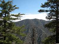 Pleasant View Ridge from Winston Ridge, 7.28.07.
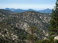 View SW from just below summit of Winston Ridge (7,003') to San Gabriel front range. Winston Peak (7,502') is center foreground; Mt. Lawlor is just behind Winston Peak; and Strawberry Peak is at right. July 28, 2007.
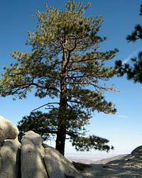 View NE from summit of Winston Ridge
 View NE from near summit of Winston Ridge
This peak can be combined with a hike to its close neighbor to the south, Winston Peak (7,502’). See Route 2 below for this combination.
Route 1
From the parking area at Cloudburst Summit (7,018’), go past the locked gate and proceed northeast down the road, the Pacific Crest Trail (PCT), to about elevation 6,700’ where a road goes to the left. Take this road to a saddle south of a bump at elevation 6,903’.
 Saddle south of bump 6903' (center back) showing trails on both sides of bump to Winston Ridge
Take use trails on either side of bump 6,903’. The trail on the left (west side of the bump) is probably in a little better shape. Proceed to the saddle just north of bump 6,903’and then follow a use trail northwest to the summit.
This route is easy Class 1 and is 5 miles round trip with about 1,000 feet of gain.
Route 2
From the parking area at Cloudburst Summit, start hiking northwest up the road that is left of, and above, the road (PCT) with the gate. In about 100 yards you will see a use trail ascending on your left. Take this use trail. It gains the ridge which heads northwest for a bit and then directly north. In just a little over ½ mile with 500’ of gain, you will reach the ridge’s high point, Winston Peak (7,502’). From here, descend northeast 800 feet to the saddle just south of the bump at elevation 6,903’. Proceed as described in Route 1.
This route is also easy Class 1 and is just under 5 miles round trip with about 1,600 feet of gain. The route is more challenging than Route 1 because, on the return, you have to recoup the 800 feet from the saddle to the summit of Winston Peak.
Getting There
From the 210 Freeway, exit at Angeles Crest Hwy (SR 2) and go north. At 9.5 miles, you will come to the Clear Creek Information Station and junction with Angeles Forest Highway. Continue straight and in 4.5 more miles you will come to the junction with the Mt. Wilson Road at the Red Box Ranger Station and trailhead. From here, continue straight on SR2 for 19 miles more to the signed Cloudburst Summit. There is a parking area on the left side (north) of the roadRed Tape
You will need an Adventure Pass (see link below) to park your vehicle anywhere within the Angeles National Forest, including this trailhead. These passes are currently sold at the Clear Creek Information Station and the Red Box Ranger Station ($5 per day or $30 for a yearly pass), which stations you pass on the way to the trailhead. Otherwise, Adventure Passes are also sold at most sporting good stores in Southern California.No permits are required for hiking in the area described here.
Camping
Cooper Canyon Trail Camp is a developed campsite, just 1.75 miles down the fire road from the gate at Cloudburst Summit. Buckhorn Campground is another option. Buckhorn Campground can be reached from Cloudburst Summit by going past Cooper Canyon Trail Camp, down Cooper Canyon, and picking up the Burkhart Trail to the campground. Alternatively, Buckhorn Campground can be reached via the Angeles Crest Highway. It is about 1 mile past Cloudburst Summit just off the highway.When to Climb
All year round. However, equip yourself appropriately when there is snow cover in the winter.Mountain Conditions
Check forecast information in local newspapers or internet weather services during the winter months. Check with Cal Trans (see link below) on road conditions and closures during the winter. Always carry chains for your vehicle during the winter when there is snow or snow is forecast.Other Information
USGS Topo Maps Mt. Waterman 7.5External Links
California Dept. of Transportation
Adventure Pass information
Angeles National Forest