
-
 19402 Hits
-
 86.85% Score
-
 23 Votes
|
|
Mountain/Rock |
|---|---|
|
|
40.69097°N / 121.62153°W |
|
|
Shasta |
|
|
8549 ft / 2606 m |
|
|
Overview
Lacking both a craggy summit and striking appearance, Magee Peak is in many ways the forgotten cousin of the higher Crater Peak and the more spectacular Red Cliffs. From some angles it is even unrecognizable as a “peak”, appearing as one of many undulations on an undulating ridgeline. In spite of its humble appearance, Magee Peak is still climbed far more often than either Crater Peak or the Red Cliffs. The reason for this is simple; Magee Peak is the terminus of two of the best trails in the Thousand Lake Wilderness.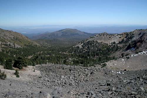 The crater from Magee Peak
The Crater Peak massif, a large volcanic cone, dominates the Thousand Lakes Wilderness. A large crater exists where the volcano’s summit was once found. Glaciers breached the crater, so no lakes have formed within it, although there are numerous lakes further east, along the glaciers former path. Four named summits are now found along the crater rim. Crater Peak is the highest and most prominent. Magee Peak is the second highest of these peaks. The Red Cliffs and Fredonyer Peak are also found on the volcanic rim. Because of Magee’s prominence and central location it once housed a Forest Service lookout. The structure has long since burned but remnants can still be found on the summit.
For sheer recreational value, Magee Peak is possibly the best summit to climb on the crater rim. One has excellent views of Crater Peak, the Red Cliffs and the interior of the crater itself, as well as of Eiler Lake and Freaner Peak, further east in the Thousand Lakes Wilderness. To the south, Lassen Peak, the Chaos Crags, Brokeoff Mountain, Mount Diller, Eagle Peak and Prospect Peak are all visible. To the west one can observe North and South Yolla Bolly, Shasta Bally, the Trinity Alps and the city of Redding. To the north, Mount Shasta dominates the horizon. The other Shasta area landmarks such as the Castle Crags, Mount Eddy, Black Butte, the Whaleback and Ash Creek Butte are also visible.
Thousand Lakes Wilderness
 Fredonyer Peak beyond the rim route leading to Magee Peak
The Thousand Lakes Wilderness is classic Cascade geography. In many ways it resembles the Oregon Cascades more than the Cascade region in California. It contains numerous tree-ringed glacial lakes, cinder cones, lava flows, vast forests and high peaks that manage to just reach the tree line. All of this is contained in a small wilderness, only 16,000 acres. Nonetheless, the area is compact, which allows for numerous trails and loops.
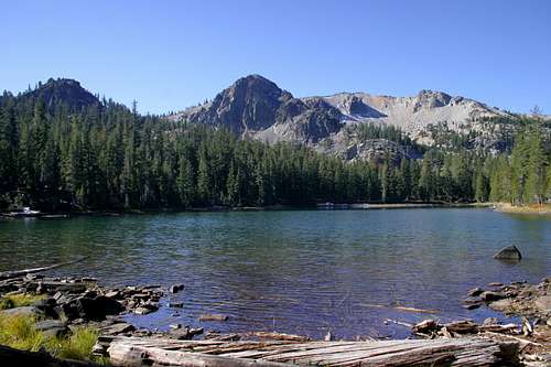
The Crater Peak Massif is the primary feature of the wilderness. It occupies the western half of the area, while the eastern half contains the Thousand Lakes Valley, Freaner Peak, Eiler Butte and a host of other, smaller volcanic features. Glaciers on Crater Peak breached the crater rim and flowed eastward, gouging out the Thousand Lakes Valley in the process. When the glacier disappeared, it left the regions namesake lakes. Granted, there are noticeably fewer than 1,000. Indeed, there are far fewer than 100. In fact, it is generally agreed that there are only ten 10 lakes of consequence in the Thousand Lakes Wilderness. However, there are numerous small pools, giving the impression that there are a lot more lakes than actually present. The largest lake is Eiler Lake, which is located beneath Freaner Peak at the eastern edge of the path followed by the glacier. The two best lakes are Everett and Magee Lakes. These lakes are the highest, and closest to the dramatic cliffs of the crater rim.
Four trailheads provide access to the Thousand Lakes Wilderness. Cypress is located in the north and is the best starting place for trips headed toward Everett and Magee Lakes. Magee Trailhead leads steeply up to Magee Peak and the crater rim. Tamarack and Bunchgrass lead into the interior of the Thousand Lakes Valley.
Routes
 The Red Cliffs along the route to Magee Peak from the Cypress trailhead
Two routes lead to the top of the Magee Peak. Both lead to a saddle on the crater rim. The most direct route is a steep climb from the Magee trailhead. It climbs 2,400 feet in 2.6 miles. The other route is longer but far more scenic. It begins on the north side of the Thousand Lakes Wilderness at the Cypress trailhead. This trail climbs 3,500 feet in six miles. Longer, with more elevation gain, the route has a much more reasonable grade. Moreover, this path travels through excellent old growth forests, passes nearby Eiler, Twin, Everett and Magee Lakes, and travels beneath the Red Cliffs and through the interior of the crater before climbing up to the junction on the rim saddle, where it meets the Magee trail. This route can be done as a day hike or as an overnighter. From the junction on the saddle it is an easy couple of hundred yards to the top of Magee Peak.
Getting There
Cypress TrailheadFrom Highway 89 at Hat Creek, head west on Forest Road 34N19. It is twelve miles on the dirt road to the Cypress trailhead. There are numerous junctions on the road, but each is well signed, so the route is clear. The road itself is in excellent condition and is easily passable for a 2WD vehicle.
Magee Trailhead
Head west on Forest Road 16 off of Highway 89 at the Ashcamp Snowmobile Park. Continue northwest on Forest Road 16 (also marked as 34N17) for roughly 10 miles. Turn right on Forest Road 32N48. Arrive at the trailhead after 1.5 miles.
***The Magee trail is no longer maintained by the Forest Service. There are numerous downed trees on the trail and some at the trailhead. Although the road itself is still passable, this route continues to suffer. Conversations with the Forest Service revealed that recent grants may allow this area to be rehabilitated, but this is only a possibility.***
Red Tape
The Red Cliffs are located in the Thousand Lakes Wilderness. Normal wilderness rules and ethics apply.Lassen National Forest
2550 Riverside Drive
Susanville, CA 96130
(530) 257-2151
Camping
The Hat Creek Valley has several excellent Forest Service campgrounds. The Honn Campground is the nearest to Road 34N19. Once off the main highway, there is dispersed camping on National Forest land.If backpacking, the best campsite is at the east end of Everett Lake. From here, the Red Cliffs form a spectacular backdrop to the lake. Magee Lake is also an excellent option although the view is not as good. It is possible to camp inside the crater and water may be available beneath the Red Cliffs, but this is a suspect source at best.