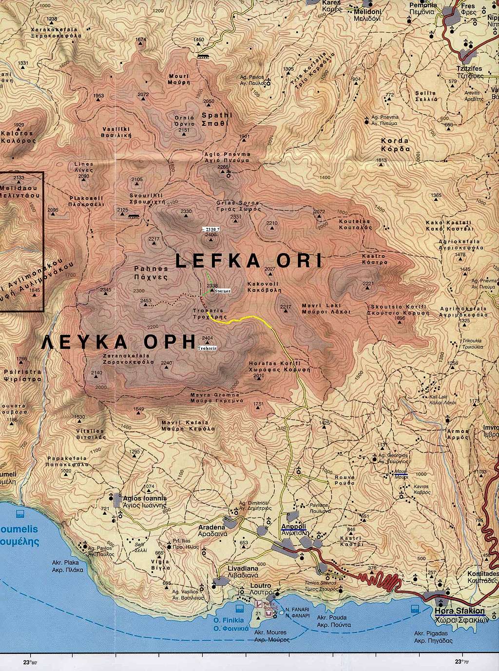
Overview
Pachnes, also spelt Pahnes, in Greek Παχνες, is the highest peak of Lefka Ori/Levka Ori (White Mountains) range, and second highest point of Crete. Only Psiloritis (Mount Ida, Timios Stavros) is higher, but only by 3 metres with its 2456 m. However, I have found one record which gives the priority to Pachnes! Quote (posted on the Sfakia-Crete forum on October 4, 2006): ‘In today's Chaniotika Nea newspaper there is an article by Paris Kelaidis that claims that the latest charts by the Greek Military Geographic service show Pachnes, of the White Mountains, the highest peak on Crete at 2,453.65 and Mount Ida at 2,453.59, a difference of 6 cm in favour of Pachnes, reversing the previous view that Mount Ida was 2 meters higher.’
One of the top two (whichever of them) it may be, Pachnes is far less popular with hikers than Psiloritis. It is also much less frequented than its neighbours from the western part of Lefka Ori, e.g. Gingilos and Volakias, that get more traffic thanks to being close to Samaria Gorge, one of the main tourist attractions of Crete.
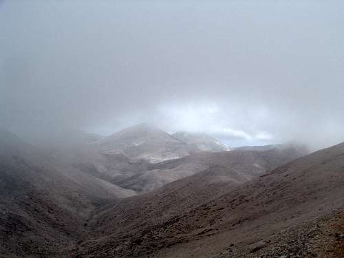
![]()
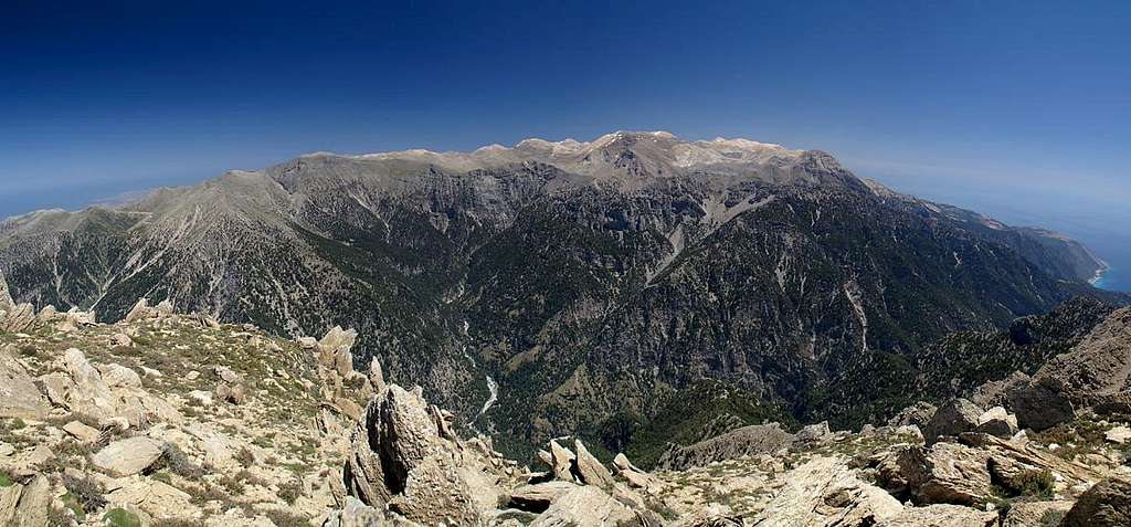
Lefka Ori, Crete's White Mountains |
Pachnes is not a difficult peak from the mountaineering point of view, it is just very remote and distant from civilisation, at least in European standards. The nearest villages are in the distance of about 10 km straight line, or 25-30 km of any sort of beaten track. The quickest way of getting to its top is to drive a 4x4 car from the south coast of Crete (the last section is 19 km of very rough gravel road from Anopoli) until the road ends, and hiking the remaining 1.5-2 hours to the summit – see southern approach below. Otherwise, hiking all the way from the bottom to the top and back in one day, from whichever side, is very strenuous and I don’t think many people would fancy doing it in one day. Therefore, Pachnes is sometimes visited as a part of multi-day trekking across Lefka Ori. All in all, even in the middle of the summer season you won’t meet crowds in this part of the massif and you’re quite likely to enjoy the summit on your own.
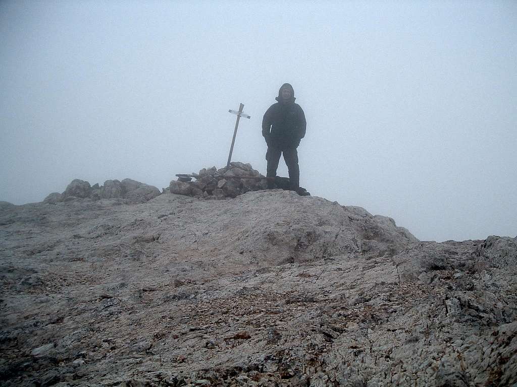
Pachnes is a great lookout peak, certainly. No stunning summit panoramas from yours truly, however, as I had dense fog on my summit day. Some excellent views from the neighbouring mountains are here thanks to Gangolf Haub. Everyone from the SP community is welcome to contribute their summit view pics, as well as post any corrections to the page, as some info is not verified!
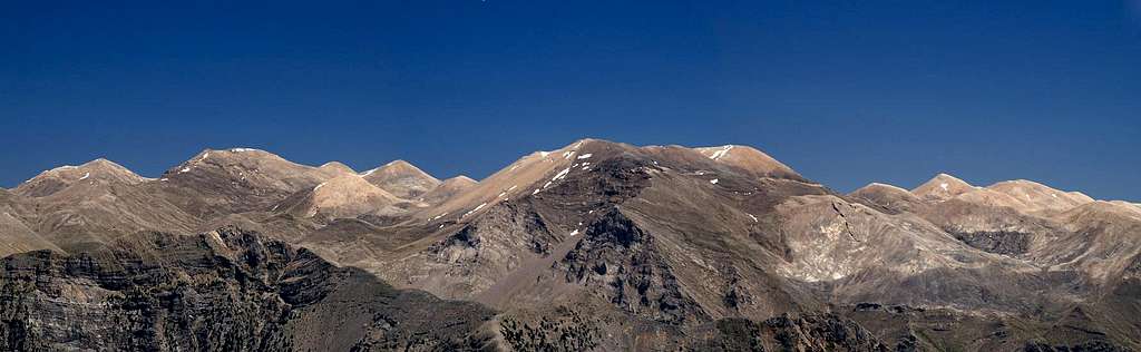
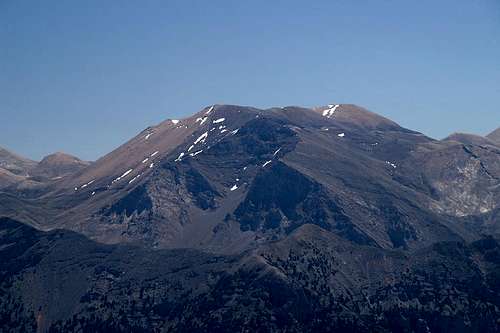
![]()
Lefka Ori from the south |
Maps
Crete, Western Part
1:100000
Harms-IC-Verlag
ISBN 3-927468-16-9
Good for driving around Crete but not reliable for mountain hiking. Also I would not trust it for some small local roads. The gravel road in southern approach (see below) is shown in a wrong way, although its end is in a more or less correct position (unlike on the next map).
Western Crete
1:100000
ROAD
ISBN 978-960-8189-12-6
Good for driving around Crete but not reliable for mountain hiking. Shows the end of the gravel road in southern approach (see below) to be in a completely wrong place (see my trip report).
Lefka Ori, Pachnes (nr 10.12 or 11.12)
1:25000
Anavasi
ISBN 960-8195-81-0
Printed on waterproof paper. I wish I'd had this one with me on the trip! I bought it only a few days later. Shows the area from Rousies and Pachnes northwards, so it doesn’t include most of the southern approach. The area south of Pachnes is covered by the map below, which I don’t have.
For the area that I visited, it is reliable and the details are shown accurately. On the other side there is a map with E4 trail and very precise text descriptions of trail sections and area details (which I haven’t verified however). Based on this map I wrote my descriptions of eastern, northern and southern approaches to Pachnes (see below). Can be useful for Kastro. The text of the Czech trip report from 2006 that I have found (in Czech and in English) seems to match the details on this map very well. However, knowing the state of Cretan cartography I would not trust ANY map in 100%! Whether on the road or in the mountains, use your sound judgement and common sense.
Lefka Ori, Sfakia (nr 10.11 or 11.11)
1:25000
Anavasi
ISBN 960-8195-84-5
Printed on waterproof paper. Covers the area south of Pachnes. I don’t have it, should be as good as the one above.
Samaria, Soughia (nr 11.13)
1:25000
Anavasi
ISBN 960-8195-85-3
Printed on waterproof paper. From the same series as the two maps above. Great for Samaria Gorge and the mountains around it (Psari, Melindaou, Gingilos, Volakias). Can be useful for the start of western approach of Pachnes (see below).
The map of the central part of Lefka Ori I have found at the Sfakia-Crete website (some other maps of Crete are also available there). Unfortunately I didn’t have it with me on the trip. I made the corrections according to the 1:25000 map (Lefka Ori, Pachnes) that I bought later, so that now it shows the details of southern approach. DO NOT rely on it for the eastern, northern and western approach. Click on the map for a more detailed description.
![]()
Central part of Lefka Ori |
Getting there/routes
Some general info about reaching Crete and the public transport there are at the Crete and Lefka Ori main pages.
As most people visit Crete by plane, car rental companies are very common and lots of them can be found in practically all the coastal towns. Renting a 4x4 is not much more expensive than an ordinary car. Example prices per day in October 2007 in Chersonissos (Hersonissos) at the north coast: Suzuki Jimny (4x4) – 40€, Hyundai Atos Prime – 30€, with full insurance. But that’s off-season, in summer it can be up to twice more expensive. Some owners are not willing to give you insurance for driving unsurfaced roads (but what’s the point of renting a 4x4 otherwise?!), so make sure about that before signing the contract. It’s worth looking around for cheaper prices, you can also try to haggle for a discount for a multi-day rental.
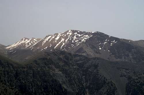
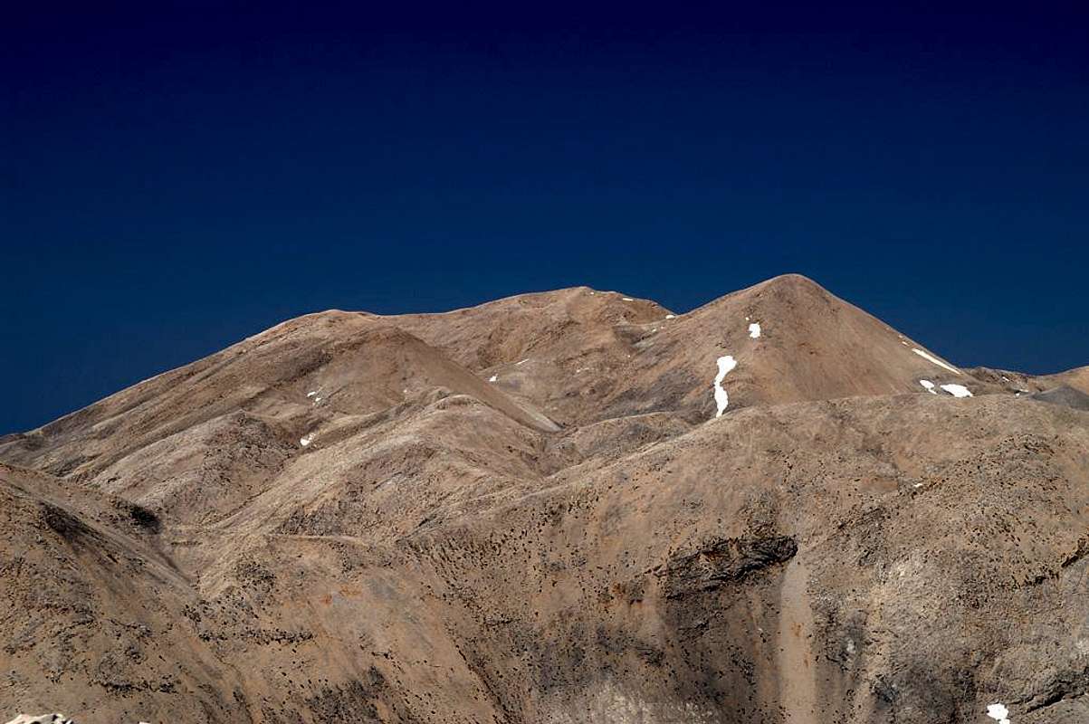
![]()
Pachnes from Psari |
|
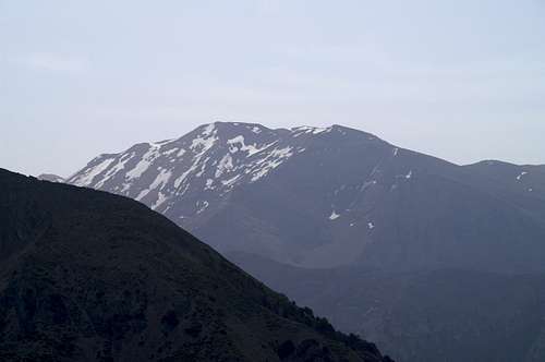
![]()
Pachnes from below Melindaou |
|
I’m not posting separate route pages, giving them in this section instead. I have climbed only one of them (southern approach). Descriptions of the other ones are based on the map Lefka Ori, Pachnes (see above) and the northern approach additionally on the Czech trip report (see above) that I have found.
Southern approach. Based on my own experience.
From the northern coast of Crete - follow the main coastal road E75 to the exit Vrysses:
From Chania (Hania) – 35 km east
From Rethymno – 30 km west
From Heraklion (Iraklion) – 100 km west
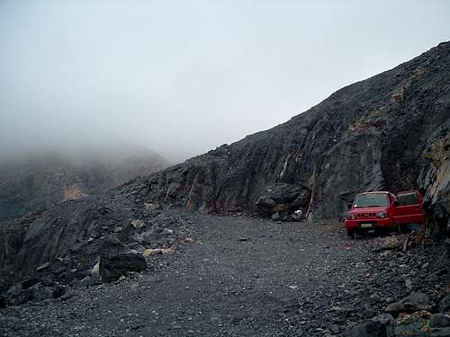
From Vrysses, drive all the way southwards to Hora Sfakion (37 km). At Hora Sfakion turn right just before the road reaches the sea coast and drive the steep, winding asphalted road to Anopoli (600 m a.s.l., 10 km from Hora Sfakion). At Anopoli turn right towards Limnia. Asphalt soon gives way to gravel. 4x4 car strongly recommended. In an ordinary car, leave it and start walking, or drive as far as you feel you won’t damage your suspension (on your own responsibility), leave it and start walking. Rough gravel road goes for 19 km (1.5 h drive in a 4x4, 6-7 h walk) up to about 2050 m. The last couple hundred metres may be closed with a wire fence by local shepherds. In that case there is a convenient parking place just below it.
![]()
Gravel road from Anopoli |
|
![]()
View from the road |
|
![]()
End of the road |
|
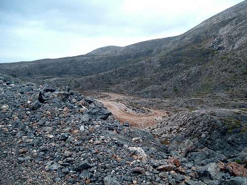
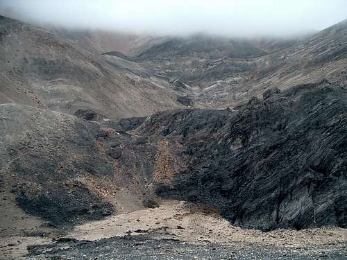
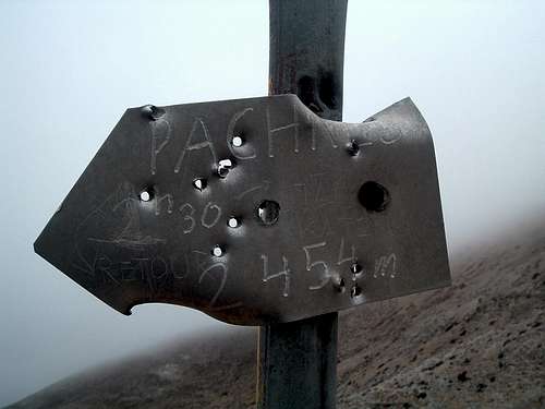
From the end of the road, the path that follows is not obvious to find. Go up the black rocky slope slightly to your right until you find red marks painted on the rocks. Take a good look around, you’ll bump into them sooner or later. Red-marked path takes you to the Rousies col at 2150 m (20-30 min.) where you’ll find an arrow sign showing the direction of Pachnes. Go that way (to your left), following a path marked with cairns to the summit of Pachnes (1-1.30 h from Rousies). The path is quite obvious and orientation is not too difficult even in the fog. See photo in the Czech report mentioned above. Also see my trip report for some more details.
![]()
Lefka Ori moonscape |
|
![]()
Arrow sign at Rousies |
|
![]()
View from the descent |
|
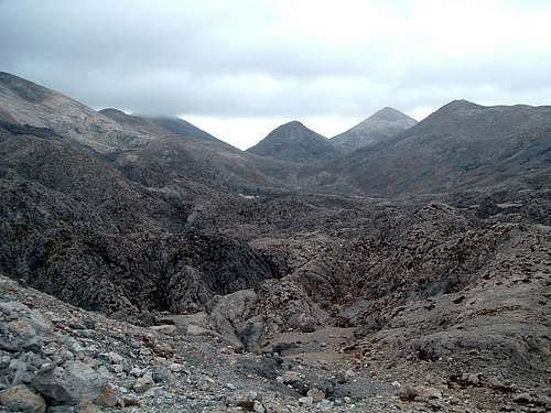
From Rousies it is a short but steep hike (20-30 min.) in the northeast-eastern direction, without any path, to the peak of Sternes (2335 m). According to the map, the area just north of Sternes is ‘Probably the most eerie and forbidding area in the whole massif. A ‘moonscape’ of black, gray and red rocks heavily eroded and impassable.’
Eastern approach. Based on the map mentioned above.
For the driving directions to Ammoudari see the page of Kastro.
From Ammoudari drive the dirt/gravel road to Tavri Refuge or walk there (according to the map there is a shortcut path that cuts some switchbacks – info not verified).
From now on the route will follow the European long distance trail E4.
At the beginning follow the described route to Kastro. Instead of going to the Kastro summit, which is a separate trip (unless you want to, of course), follow the E4 trail across the northern side of Kastro. At the beginning the route is quite evident, then for a long way the path is virtually non-existent, the E4 marking poles are few and far between, orientation may be very difficult and some sections may involve serious scrambling on rocks. Don’t go in the fog! Walk the trail to Livadha (according to the map: a huge swallow-hole/doline; 1800 m a.s.l). There should be two shepherds’ huts (mitata) and a water tank (confirmed in the report – also see below in northern approach). See photo in the Czech report. About 15 km from Tavri Refuge – this will already take most of the day. With all the orientational difficulties probably count 7-8 h or more.
At this point joins the northern approach – see below.
The E4 trail branches to the right/north (northern approach in reverse) and left. Go left to Katsiveli Refuge (1930 m; it will be probably locked). See photo in the Czech report. Further south along the trail there should be two shepherds’ huts and a water tank. 2.5 km/about 1 h from Livadha.
Here the E4 trail goes to the right/west (western approach in reverse). For Pachnes, go left (roughly in south-southeast direction) along a clear path, marked with cairns. See photo in the Czech report.
The path will bring you to the Rousies col (2150 m). 3.5 km/1.15 h from Katsiveli Refuge. At this point joins the southern approach – see info there (above) for the final part of ascent.
![]()
Pachnes from Kastro |
Alternative (according to the map, not confirmed):
From the shepherds’ huts south of Katsiveli Refuge follow E4 trail to the west for about 100 m, then turn left (roughly to the south), there should be a path. After about 200 m there should be a large cairn. According to the map, the path is barely visible but the course is obvious. Avoid the swallow-holes/dolines. Don’t use this path in the fog, especially that I’m not sure if it exists at all! The path should bring you to the summit of Pachnes. About 4 km (probably 2 h) from Katsiveli Refuge.
Northern approach. Based on the map and the Czech trip report.
From Chania, drive the local roads via the villages Nerokouros, Kondopoula, Katohori, Kambi and Tsakistra to Madaro (about 600 m a.s.l.). I have no info about the condition of the roads. Orientation may be difficult, ask the locals.
From Madaro there should be several km of a gravel road (may be in poor condition, 4x4 car recommended) to Volikas Refuge (at about 1300 m). According to the map it is locked, being restored. There should be a spring 400 m to the southeast, marked by green patch below the steep drop. In the Czech report they mentioned ‘the refuge has no water’ (maybe they just did not find it). See photo from Czech report.
From Volikas Refuge follow the E4 trail to the south. The E4 marking poles are only in the initial part, then it is unmarked. Orientation may be difficult. The Czech report mentions there is sometimes no path at all, they used the peak Spathi 2048 m to your south as an orientation point. According to them, from time to time there are cairns. Don’t go in the fog! The path should bring you to Livadha. Drinking water was here in 2006 – confirmed by the Czechs. 7.5 km/4.30 h from Volikas Refuge. At this point joins the eastern approach – see info there (above) for the final part of ascent.
Western approach. Based on the map.
The trailhead is at Xyloscalo, the entrance point to the Samaria Gorge. See the main page of Melindaou for the information how to reach it. From Xyloscalo follow the E4 trail to the peaks of Psari and Melindaou (about 4 h, see the route descriptions on those pages). From Melindaou continue to the east along E4 to the shepherds’ huts just north of Katsiveli Refuge, where the northern and eastern approaches join (see above). The path is probably unmarked but quite clear and orientation shouldn’t be difficult. About 6 km/3 h from Melindaou. For the directions to the summit of Pachnes, see eastern approach.
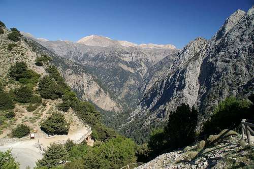
![]()
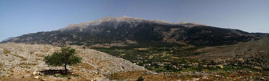
Pachnes from Samaria Gorge |
|
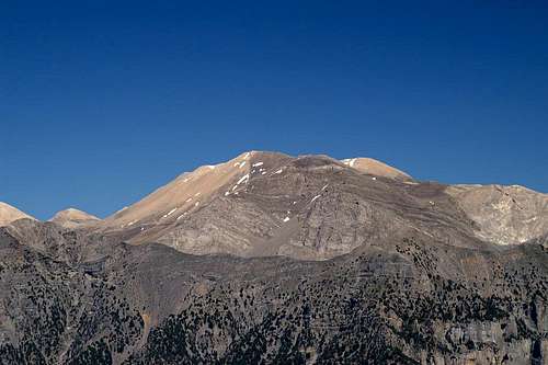
![]()
Pachnes from below Gingilos |
|
![]()
Pachnes from Gingilos |
|
Weather/when to climb
The weather in Crete is characterised by mild, rainy winters and hot, dry summers. In the higher part of Lefka Ori there is usually snow in winter.
The websites with weather forecast give only the information for the cities on the northern coast of Crete. Temperature in the mountains will be much lower (about 15 degrees C or more) than at the sea level.
Even during a sunny day at the coast, the mountains may be covered with clouds or even swept with heavy rain (that’s my own experience). Orientation in the mountains is extremely difficult in the fog.
Pachnes can be climbed all year round, although the best time seems to be late summer and early autumn. In spring there may still be a lot of snow, mid-summer is the hottest time, and in October the weather may become unstable.
Summers tend to be pretty hot and water is scarce, so make sure to carry plenty of water.
Weather link to the place nearest to Lefka Ori mountains – Souda near Chania (thanks to Gangolf Haub for the link): Souda weather forecast.
![]()
Ghost of the White Mountains |
Essential gear
Good hiking boots and standard hiking equipment, lots of water, sunscreen, good map (see above), compass and/or GPS.
![]()
Central Lefka Ori from Volakias |
Accommodation, camping, red tape
Hotels, apartments or rooms in private accommodation are easy to find in the coastal towns and villages. Accommodation should be also possible to find in some villages below the mountains, like Anopoli or Askifou. The opening times of the mountain huts/refuges described above are unknown to me – according to the available sources they are closed most of the time.
Camping is free and possible practically everywhere. Just remember to protect the nature, take your litter with you and leave the place in an even better condition than you found it. When planning to camp in or near a village, ask the locals for permission.
No permits are necessary to access the mountains. I don’t know of any other restrictions or limited access.
![]()
Lefka Ori from Psiloritis |

