
|
|
Mountain/Rock |
|---|---|
|
|
33.67960°N / 116.5902°W |
|
|
Riverside |
|
|
Hiking |
|
|
Spring, Summer, Fall, Winter |
|
|
7160 ft / 2182 m |
|
|
"Ain't No Palms, and There Ain't No View!"
The Pacific Crest Trail winds and wiggles northward through the San Jacinto Mountain Range; making its way from the oaken forests, chaparral, yucca, and cacti desert highland and eventually sub-alpine forests of pine and fir. This southern section of the San Jacinto Mountain Range is known as the Desert Divide, and on its eastern flank, you'll find several deep, eroded, boulder-strewn desert canyons. Rock composition mainly of batholithic rock and granite. The perennial "Grand Old Man of the Mountains" of the Hundred Peaks Section, Sam Fink single-handedly constructed a trail along the crest of the Desert Divide in the southern San Jacinto Mountains that became known as the "Sam Fink Trail."The views along this section of the PCT are breathtaking; the entire Santa Rosa range to the south, the San Jacinto Wilderness to the north, the Coachella Valley to the east, and Garner Valley, Thomas Mountain along with Lake Hemet to the west all seen quite clearly year-round. Many of the Hundred Peaks Section peaks in the 7000’ range are found here and easily accessed off the PCT.
Palm View Peak must certainly be one of the easiest HPS peaks to reach via the PCT, other than Spitler and Apache; but how this peak received a name denoting a “view” is a bit of a mystery AND blasphemy! First off there are no palms and there sure isn’t any view! Reportedly, the summit was not always so cluttered with trees and shrubs. From the early 1930's there was a major fire in this area; it was common practice for unnamed peaks in a fire's path to be given arbitrary names by fire fighters, and this was probably the case. If the view were less obscured, the summit would provide a view to the north of Palm Canyon and Palm Springs.
Palm View Peak was added to the HPS Peak List in 1962.
 The only "palms" I saw!
The Drive
From I-15, north or southbound, you can exit in Temecula onto Winchester Road (Hwy 79N) and head north to Hwy 74E and continue on through Hemet and up the slope on pleasant winding mountain roads, complete with competition "S-curves" to Mountain Center. Once you reach Mountain Center at the intersection of Hwy 243 to Idyllwild and Hwy 74 to Palm Springs, stay to your right and on the 74. In approx 8.5 miles, you will reach Morris Ranch Road on your left, a fire station sits on the corner. Turn left here.Or you may exit in Temecula onto Hwy 79S and drive east toward the San Jacinto Mountain range for approx 20 miles, then turn left onto Hwy 371 for Anza. In another approximate 20 miles up a long slow grade to about 4500' through dry rocky terrain, passing the Temecula Olive Oil Company ranch and Cahuilla Casino, you will reach Hwy 74 bound for Palm Springs to the east and Mountain Center to the northwest. Turn left at Hwy 74, there is a nice restaurant on the right hand corner, Paradise Cafe; probably the ONLY good place to eat for many, many miles. Approx 3 miles after turning left, you will come upon Morris Ranch Road on your right with a fire station on the corner, turn to the right here. You will pass a sign for the trailhead to Thomas Mountain on your left prior to reaching Morris Ranch Road.
Once on Morris Ranch Road, drive approx 3.5 miles, passing the Joe Scherman Girl Scouts of America Camp and many mobile homes. On the right, you will come to a gate with a sign for "Cedar Springs Trail." Park in the vicinity and be sure to post your National Adventure Pass.
Elevation is approx 5300' so icy road conditions may exist in winter.
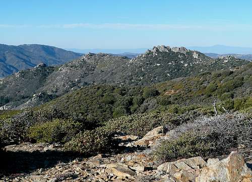 Cone Peak in the distance.
The Hike
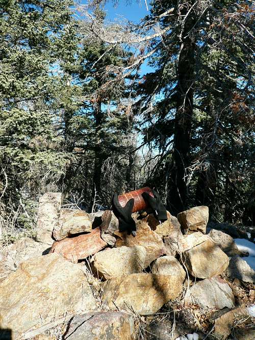
From the gate at Cedar Springs Trail trailhead on Morris Ranch Rd, begin your 4 mile trek to Palm View Peak. You will have no choice but to stay on “The Trail” due to the barrage of “No Trespassing” signs, wire fences and gauntlet of gates (there are 4 of them to keep range cattle out of National Forest). There are even picnic tables and trash cans along the way. Watch out for tiny nearly useless cairn!
For the first 3/4 mile, the trail alternates between trail and road. At the third gate, you will finally be entering the National Forest boundary and feel you have escaped the confines of bureaucracy, but wait…one more gate. The gentle switchback trail takes you to the PCT for another 1.5 miles; great views of the canyon and surrounding area along the way, but as this portion of the trail remains in the sun during spring and summer, take care to protect yourself from the heat and rays. The only running water can be found dribbling from a pipe in the clearing near the picnic tables.
At the saddle of PCT and Cedar Springs Trail junction, there is a large half-busted sign pointing to several different trails, turn left onto the PCT and continue on trail for another 1.5 miles toward Peak 7123’ (bench marked on topo). You will drop slightly into a saddle after passing a noticeable peak on your left. Upon ascending past the saddle, watch for a cairn on the right side of the trail to mark a faint trail to Palm View Peak’s summit. You will have a bit of bushwacking from this point and there are many many game trails to throw you off course. Keep heading northeast for skyline through the pines. The summit block is merely a pile of assorted stones with a red coffee can for the register; “ain’t no view here!”
Admin Stuff
Please stop by the Idyllwild Ranger Station to pick up your permit, or just to visit. National Adventure Passes are required for parking near access to national forests and can be purchased from the ranger station or various area merchants.Be mindful of private property and courteous parking at the trailhead. There is not much parking space available at this trailhead, especially when roads are iced when abundant snow.
[img:368368:aligncenter:medium:Dave never told me that he had family on Palm View Peak. :/]