
|
|
Mountain/Rock |
|---|---|
|
|
45.08600°N / 117.349°W |
|
|
Hiking, Mixed, Scrambling |
|
|
Summer, Fall |
|
|
8676 ft / 2644 m |
|
|
Overview
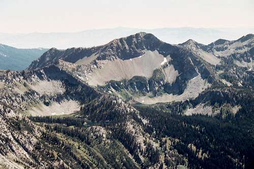
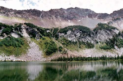
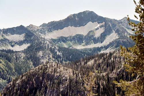 The north side of Peak 8,676 from the Cached Lake Trail
 East Ridge
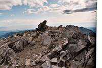 The summit
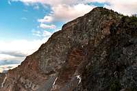 North Face
Depending on how things are counted, this unnamed summit is about the 50th highest point in the Wallowa Mountains. While that may not sound too impressive, this is really a tribute to how spectacular the Wallowas are because this is really an impressive mountain. It forms the dramatic headwall of the cirque above Culver Lake that due to its steep slope and crumbly substrate of mostly Hurwal formation rock is probably not climbable – at least by a sane person. The west wall of the cirque is formed by a black dike of basalt that actually leans beyond vertical for part of its roughly 900 foot height. Besides Culver Lake there are two other lakes and five larger ponds on the peak or its connecting ridges. It is also one of the highest summits on the south Wallowa front and has a respectable 736 feet of prominence.
The mountain forms an elongate dome near the south end of the Eagle/East Eagle divide. The backed sedimentary rock of the Hurwal formation gives it a beautiful color mix of orange, cream, brown and gray that changes with varying light levels. The double ringed headwall above Culver Lake is formed by a lower ring approximately 500 feet above the water and the upper forming a 700 foot vertical wall that terminates 1,600 feet above the lake. The two rings are separated by a steep slope of scree that rises over 400 feet. The summit has a vertical lift of nearly 2,800 feet above Eagle Creek and nearly 4,200 feet above the East Fork of Eagle Creek. A hike from the Main Eagle trailhead requires an elevational gain of 3,685 feet. The entire north basin area has been blasted by repeated avalanches which leave much of the lower forest formed of stunted damaged trees.
There is no register, but a small cross has been erected along with a small cairn. The views are great in every direction. It is possible to look down the Eagle Creek canyon and across Baker Valley to the Elkhorn Mountains to the southwest. North the high divide between Eagle Creek and West Eagle Creek across to the spectacular south side of unnamed Peak 8,587 to Hidden Peak and Eagle Lake can be panned. Looking east to the southeast the divide between Eagle Creek and East Eagle Creek, which this peak is part of has many rugged points and the further peaks such as Cusick, Jackson and marble can be seen. The south Wallowa front landmarks of Krag Peak and Red Mountain rise up abruptly from the range country south of the mountains. To the direct south the pyramid of Lookout Mountain many miles away is visible. At the southwest foot of the summit is the large Lookingglass basin with its deep lake and the unnamed multi-summited mountain behind it. Unnamed Peak 8,676 is truly a worthwhile destination.
Access
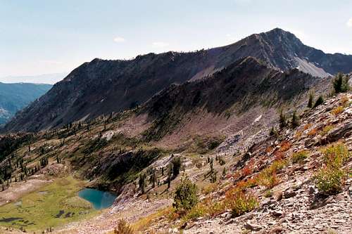 South side of the east connecting ridge and unnamed tarn
There are two primary ways to reach this summit; both of which start at the Main Eagle trailhead on the East Fork of Eagle Creek. To reach the Eagle Creek trailhead from Baker City and Interstate 84, get on the interstate in downtown Baker City and go north for five miles to Exit 298. Exit and turn right on Chandler Lane/OR Highway 203 (also called the Medical Springs Highway). Continue for 18 miles to the small town of Medical Springs. There are only a few buildings here. Turn right on the Big Creek road that runs southeast away from town. After approximately three miles the road enters National Forest lands and is numbered Road 67. Stay on this road for approximately 15 miles until it meets Road 77 (Eagle Road) after crossing the West Eagle Creek. Turn left on road 77 and go almost a mile. Road 77 turns away to the left, but keep straight on road 7755. Continue approximately five miles to the Main Eagle trailhead. This drive requires approximately an hour and a half from Baker City.
Route Overview
 Looking down the rugged east ridge.
There are relatively few ways to reach the summit of this peak. One can get on the side ridges and scramble to the top, but the direct face is too steep and the substrate very crumbly to be climbed. This page covers routes from the north side only. It is probably possible to climb the mountain’s east or south aspects from the East Eagle trailhead, but this would be a more rugged and difficult option, thought the approach would be shorter.
From Lookingglass Lake
 West side of summit
To reach Lookingglass Lake from the Main Eagle trailhead hike north on the 1922 trail for 4.1 miles to the junction of trail 1921, then take the 1921 trail for 2.6 miles to the lake. The jumping off point to climb the mountain would actually be a little before the lake. The northwest ridge of the mountain has a band of cliffs running most of its length on the Lookingglass side, but there are at least a couple points one can scramble up through them. Both are in the vicinity, but just before the first pond encountered on the trail that is northwest of the main lake. There may be more ways up through the rocks. Once on top of the cliff band, it is an easy hike up to the summit regardless of where you come out. Bear right across and up the slope or continue straight up to the ridgeline and follow it to the top. The latter option gives better views of the Culver Lake cirque.
From Bear Lake
 East Ridge
 Last Stretch
To reach Bear Lake from the Main Eagle trailhead hike north on the 1922 trail for 4.1 miles to the junction of trail 1921, then take the 1921 trail for one mile to the junction with trail 1921A. Its another mile to Bear Lake. It is easy to miss the curve to Bear Lake and end up at Culver Lake, if so simple turn around a short distance and find the trail north. Bear Lake is so inviting one probably would want to just stay there, but to climb Peak 8,676 it is necessary to get on the ridge above it. It’s approximately an 800 foot climb to the ridgeline and the middle of the slope is blocked by crumbly outcrops and cliffs. There are a very few ways visible to pick your way through this, most are to the left behind the lake. Further left, the slopes are easier, and the entire rocky area can be bypassed, but this requires a longer scramble.
Once on the ridge top turn right or east. Depending on where the ridge was attained above Bear Lake there will be two or three small ridge points to bump around before starting up the northeast ridge of the summit. This ridge starts easy, but gets steep being formed of a long series of ledges that are just steep enough with the loose gravel to require hard hand over hand scrambling. If staying directly on the ridge some class 4 or better outcrops must be climbed and some of the rock is loose. Avoiding them puts one on the difficult ledges that invite a slide at each step and require long tedious picking back and forth up the slope. From about 8,000 to just over 8,400 feet this is a very difficult route, but once the northeast ridge joins with the southwest ridge things become much easier. This route requires approximately 2.5 miles of sometimes rough scrambling beyond Bear Lake.
Red Tape
 Big Basalt Dike
The Eagle Cap Wilderness has become very popular and resource damage is becoming common in some areas. Complete regulations are available on the Wallowa-Whitman website. Some of the more important regulations to consider for a trip into the Needle Point area are listed as follows:
Entrance into the Eagle Cap Wilderness with a party of more than 12 persons and/or 18 head of stock is prohibited. Large groups multiply impacts to the wilderness and disrupt the solitude of others.
Camping within 100 feet of lakes and 100 feet of posted wetlands unless the site is designated as a campsite is prohibited.
Eagle Lake is closed to campfires due to lack of firewood and excessive impact. Campfires are prohibited within 1/4 mile (1,320 feet) of this lake. If coming from an extended hike elsewhere, especially the Lakes Basin, be aware of specific area regulations that may apply in those areas. These would be listed on the above website. It is important that all wilderness regulations and no-trace camping techniques be followed in these especially sensitive areas.
Entering the Eagle Cap Wilderness without a permit is prohibited. The free, self-issue permits are being used to collect visitor use information only. Only one permit per group is necessary. The self issue Registration/Permit boxes are located at each trailhead near the information board. Place the trailhead copy of the permit in the registration box and carry the visitor portion with you while in the wilderness. It is helpful to have the permit tied to a backpack or saddlebags where Wilderness Rangers can see them.
A Northwest Forest Pass is necessary for parking at some Eagle Cap Wilderness Trailheads, including Eagle Creek. These mandatory passes cost $30 per year, or $5 per day, and are for sale at all Wallowa-Whitman National Forest Offices, the Wallowa Mountains Visitor Center in Enterprise, or at local businesses in the towns of, Wallowa, Enterprise, Joseph, Wallowa Lake, La Grande, Elgin and Baker City. Northwest Forest Passes may also be available at commercial outlets and national forest offices in other locations around Oregon and Washington. The passes will allow visitors to park at many other national forest trailheads across Washington and Oregon.
Camping
 Three Lake Basins to Choose From, (L-R) Bear, Culver, Lookingglass.
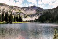 Bear Lake
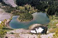 Culver Lake
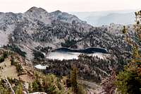 Lookingglass Lake
 Bear Lake and Peak 8,587
There are no developed campgrounds in the Eagle Cap Wilderness, but at large camping is allowed basically anywhere. However, camp in the trees if possible and avoid meadows and places easily trampled. Good camping locations are scarce in the lower end of the Eagle Creek basin, but starting near the 1921 trail junction (about four miles up) some descent camping spots can be found. Closer to the mountain up the 1921 trail there are three lakes that provide camping. Lookingglass Lake, the largest is 2.6 miles up the trail from the junction with 1922. This beautiful and deep lake is heavily used so don’t expect privacy.
A mile up the 1921 trail turn left on the 1921A for a short distance to Culver Lake for another camping option. This horseshoe shaped water body has a few camping spots on the northeast side. This is an unusual lake, not only for its shape and beautiful turquoise color but for the small, much deeper, dark satellite pond on the southeast corner that is separated by just a few feet of glacially deposited material. It’s a tarn formed on the lake edge. Also almost the entire area has been blasted by avalanches and is dominated by small bent trees indicating this wouldn’t be a good destination for a winter hike. The summit of this mountain forms a dramatic headwall above Culver Lake, but there is no good way to climb it from here.
The third lake camping option is the beautiful Bear Lake. Find the trail running east from Culver Lake for less than a mile to Bear Lake. This small lake is nestled in a long hanging basin with the front fringed by a forest of graceful spruce and subalpine fir and the back terminating in an open subalpine wetland butting up against the ridge. There are ample camping spots here, but especially on the lake’s east side.
There are campgrounds at the Main Eagle trailhead; Two Color, about four miles before the trailhead and Tamarack less than a mile east on the 77 road after its first junction with road 67.
 Culver Lake
When To Climb
Most people climb this mountain in the summer or fall. Getting here in the spring or winter would be a serious chore and impossible unless one was skilled at extended back country winter travel. Avalanche danger on most of this mountain would be high. In the summer come prepared for a variety of weather conditions regardless of the forecast. Local weather can change suddenly and be severe at any time.Mountain Conditions and Information
P.O. Box 907 / 1550 Dewey AvenueBaker City, Oregon 97814
(541) 523-6391
TDD (541) 523-1405
Wallowa Mountains Office and Visitor Center
Eagle Cap Ranger District
Wallowa Valley Ranger District
88401 Hwy. 82
Enterprise, OR 97828
(541) 426-4978
(541) 426-5546 TDD (541) 426-5609
La Grande Ranger District
3502 Hwy. 30
La Grande, Oregon 97850
(541) 963-7186
Visit the Wallowa-Whitman National Forest webpage for current conditions including weather, advisories or other valuable information.
NOAA Forecast
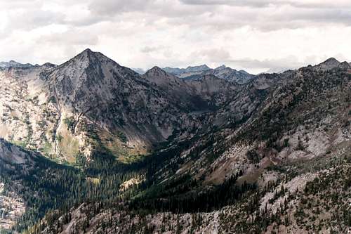 The view northeast to Needle Point and Eagle Lake