
-
 7248 Hits
-
 87.76% Score
-
 25 Votes
|
|
Mountain/Rock |
|---|---|
|
|
39.96420°N / 114.396°W |
|
|
White Pine |
|
|
Hiking |
|
|
Spring, Summer, Fall, Winter |
|
|
9370 ft / 2856 m |
|
|
Overview
 Ibapah Peak from the summit.
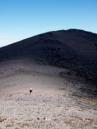
Baldy Peak resides in White Pine County, NV. This peak gets little traffic except from those interested in Prominence peaks of Nevada. Baldy Peak comes in at 106 on Nevada's Prominence List. Some maps show Baldy Peak as BM Smoothie. Views are great from the summit. To the south on a clear day one can see Wheeler Peak, North Schell Peak and the snow capped peaks of the Schell Range. To the west one can see Becky Peak. To the north and in the distance you can see Spruce Mountain as well as the Ruby Mountains on the edge of the horizon. Great views to the East of Ibapah Peak in Utah can also be enjoyed. Straight East from the summit you can get a look into the Goshute Indian Reservation .
Baldy Peak requires about 25 miles of off roading in order to reach it. It is far from civilization. The closest community McGill which is along HWY 93 just North of Ely, NV. Be sure you have plenty of gas and supplies. Keep your eye open on the drive in, you are likely to see wild horses.
Getting There
The last 23 miles or so to get here is on dirt roads. You should be able to reach the trail head with a good 2WD. However, a high clearance vehicle is highly recommended.From Ely, NV
Drive North on HWY 93 for approx 39.1 miles
From Here, follow the GPS Coordinates in the table below and reset your Odometer.
| WPT | Directions | Latitude | Longitude | Distance to Drive (mi)/ Current Mileage from HWY 93 |
|---|---|---|---|---|
| WPT 1 | Turn Right onto SR-2 [CR-18] | 39°47'42.9"N | 114°43'57.2"W | 10.8 |
| WPT 2 | Turn Left (North) | 39°49'34.7"N | 114°33'41.0"W | 7.5; 10.8 miles from HWY 93 |
| WPT 3 | Turn Left | 39°59'07.2"N | 114°30'56.7"W | 4.35; 15.15 miles from Alt HWY 93 |
WPT 4 | Turn right | 39°58'49.2"N | 114°26'25.7"W | 2.91; 19.3 miles from Alt HWY 93 |
| WPT 5 | Stay Straight on Main Road | 39°57'25.8" | N114°24'56.6"W | 0.61; 22.21 miles from Alt HWY 93 |
| WPT 6 | Turn Right | 39°57'45.4"N | 114°24'34.5"W | 0.23; 22.82 miles from Alt HWY 93 |
| WPT 7 | Turn Right | 39°57'49.5"N | 114°24'26.0"W | 0.11; 23.05 miles from Alt HWY 93 |
| WPT 8 | Park | 39°57'43.7"N | 114°24'21.3"W | 23.16 miles from Alt HWY 93 |
From Salt Lake City, UT
- Just before this turn you’ll cross into White Pine County.
From Here, follow the GPS Coordinates in the table below and reset your Odometer.
| WPT | Directions | Latitude | Longitude | Distance to Drive (mi)/ Current Mileage from HWY 93 |
|---|---|---|---|---|
| WPT 1 | Turn Left off of Alt HWY 93 | 40° 6.281'N | 114° 114° 33.134'W | 8.85 |
| WPT 2 | Turn Left | 39°59'13.5"N | 114°30'52.6"W | 4.15; 8.85 miles from Alt HWY 93 |
WPT 3 | Turn right | 39°58'49.2"N | 114°26'25.7"W | 2.91; 13 miles from Alt HWY 93 |
| WPT 4 | Stay Straight on Main Road | 39°57'25.8" | N114°24'56.6"W | 0.61; 15.91 miles from Alt HWY 93 |
| WPT 5 | Turn Right | 39°57'45.4"N | 114°24'34.5"W | 0.23; 16.52 miles from Alt HWY 93 |
| WPT 6 | Turn Right | 39°57'49.5"N | 114°24'26.0"W | 0.11; 16.75 miles from Alt HWY 93 |
| WPT 7 | Park | 39°57'43.7"N | 114°24'21.3"W | 16.86 miles from Alt HWY 93 |
 Driving Directions. Click for more info.
Red Tape / Camping
None. There are no concessions (i.e., no gas, lodging, food, campgrounds) on the Wildlife Refuge. Camping is permitted anywhere within 100 feet of a designated road as long is it is not within 1/4 mile of a water source. Campfires are permitted using dead wood.
Route
 |
 |
 |
 |
 |
 |
From the parking spot head East up the ridge through the trees. You will cross over the false summit. You will see the summit almost straight East of you from here. It’s a short hike over to the summit. There is a register on the summit. Just to the NW of the register is the Benchmark which is marked “Smoothie.”
Total Distance to summit: 0.58 miles
Net Elevation Gain: 603 ft.
Starting Elevation: 8763 ft.
Summit Elevation: 9370 ft.
External Links
