
|
|
Mountain/Rock |
|---|---|
|
|
36.56760°N / 118.24874°W |
|
|
Inyo |
|
|
Hiking, Mountaineering, Scrambling |
|
|
Spring, Summer, Fall, Winter |
|
|
12077 ft / 3681 m |
|
|
Overview
Is it a separate peak? A high point along the Mt. Irvine east ridge? Or merely a radio repeater placement spot? USGS topos list the false summit (about 1/4 mile east of the true summit) as Point 3681.
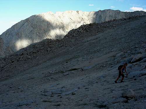
The true summit of Candlelight can be seen further up the ridge from the false summit (high point, top left). This view from the Whitney Portal area shows the main section of the East Ridge route. (Mt. Irvine is at the rear center.)
Regardless of your view of Candlelight Peak, this is one of the better day hike trips originating in the Whitney Portal area, and arguably a well-kept secret for those looking to stretch their legs via the Meysan Lake trail or take their 3rd class abilities a step higher via the East Ridge route above Lone Pine Lake.
Part of the allure of this peak is that it falls just outside the Whitney permit zone, so day hikes can be accomplished at any time without the bureaucratic endeavors endemic to points further west.
Getting There
The trailhead and directions are the same for Mount Whitney.
For the East Ridge route, you will start from the Mt. Whitney Main Trail trailhead and your destination will be Lone Pine Lake, which sits just below and east of the Main Trail at about 3 miles. (There is a sign pointing you left as you hike up.)
For the South slope or the South West slope, you will start at the Meysan Lakes trailhead which is 11.3 miles from Lone Pine (just under 1 mile from the Whitney Portal on the Portal Road).
Red Tape
Thankfully, this hike falls outside the Whitney "Zone" and no permits are needed for day hikes.
Overnight trips require wilderness permits and can be obtained in person at:
Eastern Sierra InterAgency Visitor Center
Visitor Services/Wilderness Permits
760-876-6222
760-876-6228 TDD
Junction Highway US 395 & SR136 (1 mile south Lone Pine)
Lone Pine, CA 93545
Hours: Daily 8:00am to 5:00pm
or to reserve permits in advance, contact:
Wilderness Permit Office
Inyo National Forest
351 Pacu Lane, Suite 200
Bishop, CA 93514
Reservation Line: (760) 873-2483
More information can be found at the Inyo National Forest website.
Camping
There are a number of wilderness camp spots starting about 3 miles up the trail and at Grass Lake and Meysan Lake.
Information & Weather
The main gathering place for current Mt. Whitney area info is the Mt. Whitney Portal Store Message Board (which has plenty of useful info when you either use the Search button, or sift through the many newbie posts). NOTE: Try not to post any messages on the board along the lines of "What's the weather going to be like on such-and-such a day, next month or next year." No one knows and it makes you look extremely green. (As Doug Thompson of the Portal Store says, "If you have to ask, you shouldn't be on the mountain.") You've been warned.
That being said, weather can be tricky and change dramatically, depending on the season, so use the following links (along with what people have posted on the above sites about current conditions):
Weather and forecast info can also be found on the Mt. Whitney Portal Store Message Board.
History & Etymology
It's unknown who first climbed to this point (odds are pretty good that it was hundreds, if not thousands of years ago, given the easy slope from upper Meysan Lake). The summit register, however, includes a laminated page from the first register and lists a trip via the East Ridge by Carl Heller, Steve Christensen, Wayne Perry and John Turnbull on June 3, 1961.
It can be speculated that because the high point on this ridge receives the first and last rays of sunlight (as viewed from the Portal area) the Candlelight name was one of obvious intent.
Curiously enough USGS lists the eastern "false summit" as point 3681, though the "true" highpoint is about 1/4 mile further west.
Candlelight Peak summit viewed from further west on the ridge.
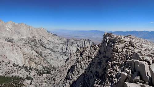
Candlelight Peak is the highest bump on the far ridge, right of center (as seen from the Thor summit plateau).
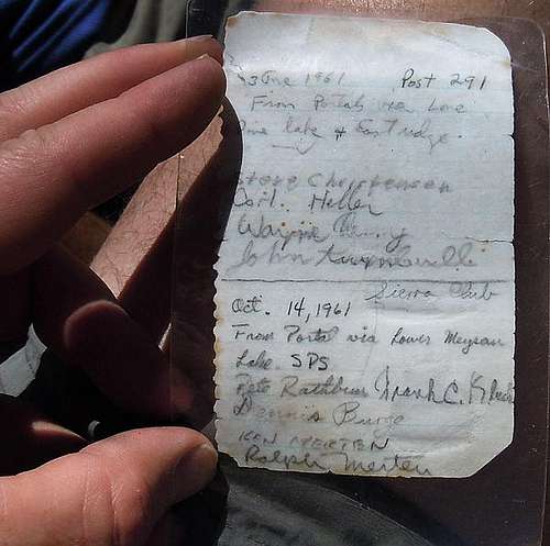
June 3, 1961 entry by Carl Heller & company.