
-
 14100 Hits
-
 70.01% Score
-
 5 Votes
|
|
Mountain/Rock |
|---|---|
|
|
42.26511°N / 74.47383°W |
|
|
3600 ft / 1097 m |
|
|
Overview
This mountain is one of them peaks that is ignored by everyone but them trying to get in the Catskill 3500 club, i even had this peak as a rainy day alternative because its closest to me and seemed easy from what ive herd from everyone. This was one of the biggest mistakes i could have made, after climbing bearpen i discovered that this mountain was far better ten slide mountian, the most well known mountian in the Catskills, this in fact is the hidden gem no one should miss because of its trail status, location outside of the park by 5 miles, and lower height (after all lowly twin provides such a good view).With that said its trail-less status should be ignored, as you have to be real dumb to get lost in the bushes, their is state maintained snowmobile trails leading to the top, and in fact theirs 3 easy approaches the the summit ridge,
one at 1800 feet climb and 2.6 miles, (the hesenger road approach, a semi steep jeep road with numerous switch backs, many camp worthy spots, and the shortest arpoach to the summit(enjoying just bearpen, i dont consider johnston hollow worthy to see all this peak has to offer)
one at 2000 feet climb and 4.3 miles (ski run road, tracks the long rigeline of bearpen, allows one to climb roundtop and north bearpen, and visit the skate pond),
and one at 800 feet and 1.6 miles (johnston hollow road, used to bag vly mountian and bearpen in one day)
This is a peak you can take even grossly out of shape friends up, their huff and puff and complain till bearpen shuts them up with its rewards at the summit, or little kids even as their is nothing technical about this peak.
A steepish mountian road, mainly dirt will take you to the top, many flat sections will allow you to catch your breath, and ofcource not to be overlooked, the limited views the long
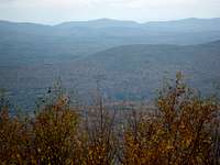
straight sections of road provides when you sit to take a break, in fall windham high peak demands you to look at it with all its reds, yellows greens, saying why bother going higher all you need to do is look at me. After snubing windhams crys many times you will come to a semi rocky section that last for a few hundred feet, the only bad section of trail, soon after you will see a rocky wallish area that says to you climb me to see something, so you do, and at top bearpen causes you to freeze with its wonderful 160 degree view, Windham, the blackheads, the entire escarpment wall, westill, halcott, all come into view, along with the schohaire reservoir and another lake on top of a mountian. its at that point you relise you didnt have to climb the wall, the trail in 75 feet looped around the wall and came to this view. this is the point where you feel you got it all, but you still dont, continue down this trail and turn right at the split, edd west will great you on a tree, making you relize this was an old ski area at some point, and provide a view of 210 dergrees allowing slide to come into view with to many other peaks to name, from here out, take the time to explore the summit a little theirs plenty of other rewards to be found including a pond off on one of the other trails and views to the west. and most of all to satify peak baging near the rockwall be sure to go up to the trail that comes out of the clearing and heads north to go off trail and wonder in the thick brush to bag the true summit, 25-50 feet off that trail somewhere
You will also notice the lack of confiers on top, this mountian is mainly 1st and 2nd growth it was heavly logged, farmed, and was infact a ski area (a nice one at that till the dec messed up a survey to take it for free)
http://skikabbalah.com/lostNY/BEARPEN%20STORY.htm - the ski story
also on hesinger road trail, at the major splits always go left, as that is the best trail up, (only 2 mojor splits, one near the bottom just after the switch backs, and then ski run road, (usually a big mud hole seen from hesinger)


Getting There
Follow rt. 23 from oneonta, or from 87 to Prattsville near the big green bridge take countey route 2 to don irvine road, then turn on the dirt hesenger road, park near the gate on the left, this is the trail to the summitRed Tape
The private signs at the top are left over from the ski area this is all state land, do not go onto little west kill land past the second gate on hesinger, you sould use the first not the 2nd oneCamping
no comping above 3500 feet, water is somewhat hard to come by up here, may not be the best campingExternal Links
http://skikabbalah.com/lostNY/BEARPEN%20STORY.htmhttp://catskillmountaineer.com/hiking-bearpen.html