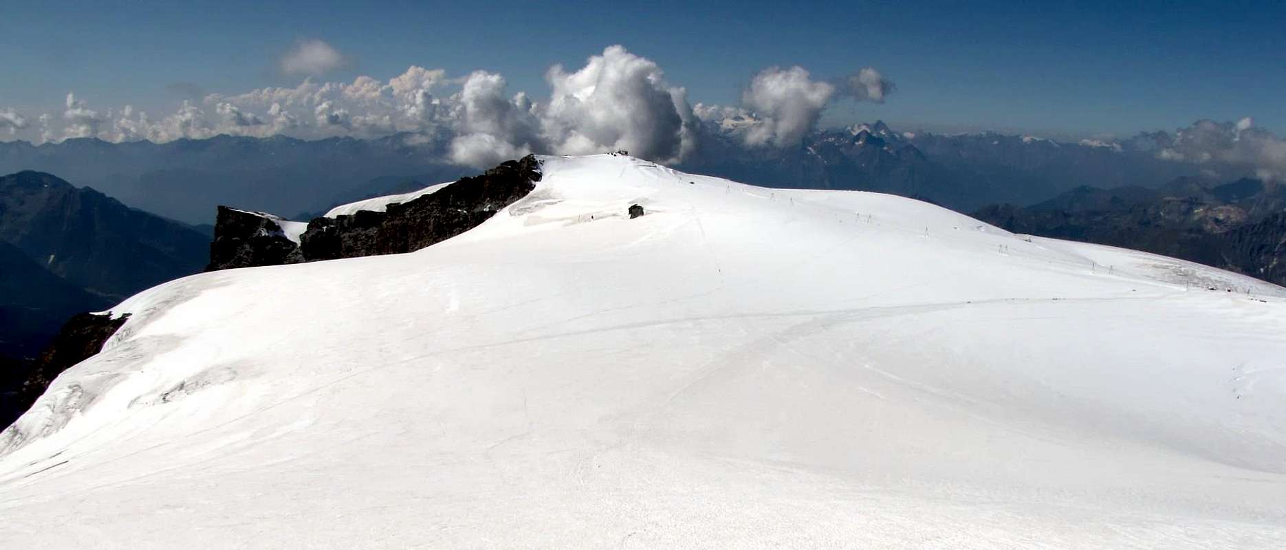
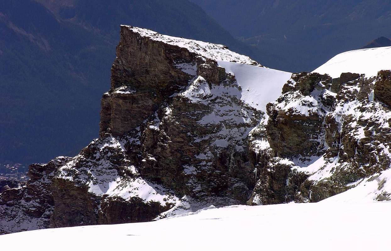
More particular mountain to form of great and almost flat glacial cap, inclusive among the North Breithornplateau, the Glacier of Southwest Aventine, also of Ventina, and the Great Glacier of Verra to East. Better in detail, among the Saddle 3.796m, that separate it from the Klein Matterhorn or Piccolo Cervino (3.881m), the Breithorns Pass (3.818m) dividing with his three homonym Summits (4.165m, the most greater or Westernern Breithorn and 4.160 m the Central); while on the Southwestern slope its West Crest goes down, not very well delineated cause her "fusion" among the two glaciers, to the Southern Aventine Hill (3.700m around), sets "to horse" among the homonym glacier and the Plateau Rosà. Finally in South direction it goes down with an important and sinuous buttress toward the Verra Rocca also Great Tower of Verra, among the Verra/Ventine Walloons, always in Val of Ayas. The same, in progression from North-northeast towards Souh-southwest and departing from the Saddle 3225 meters, form and outlines him with the Quotas 3.321 meters and 3.230/5 meters around, the Rocca of Verra (the only one signalled in the various Papers & Maps) or Quota 3.129 meters, Tower site among the Lakes of Tzère also Céré and the Grand Lac on his Western Slope, and easily attainable from the I Camp out City of Mariano, in the Walloons of Adventine/Céré, and the famous and very more frequented Lac Bleu in Val of Ayas, near the Verraz morainic and wide Tableland. On these Oriental walls of the various quotas some interesting itineraries of rock have been traced, tall also over the 600 meters, on which it is easy from the floor valley, near the picturesque Lac Bleu (2.211 m), to observe hocked the climbers. Easily attainable from the Testa Grigia (= Grey Head; 3.480m; Refuge Guides of Cervino) or from the Shelter of the Teodulo, neighbor the with same name Hill, (3.316m), it is not top very frequented and subordinate to the frequent trips that are addressed to the most famous and elevated Western Breithorn or to the Little Cervino. It is not almost never generally ascension to herself how objective and final purpose, on the contrary you can be connected to the slope of the first two Breithorns (that Western and the Central one), if not even with the complete turn of the Breithornplateau and arrival up to the Klein Matterorn or Piccolo Cervino (you see to the necessity First Ascents). From his Top splendid views that space from the Chain of the Petites ones and Grandes Murailles, to the Dent of Hérens, to the Matterhorn and the whole wide GROUP of the Mount Rosa up to the Dufour Point also Dufourspitze (4.634m), the most elevated of the whole great Mountain Chain, at the end of the same, as well as to Gnifetti Point also Signalkuppe (3.554m) with the Hut Queen Margherita, the most elevated in the whole Europe.
Montagna alquanto particolare a forma di grande e quasi piatta calotta glaciale, compresa tra il Breithornplateau a Settentrione, il Glacier d'Aventine, o di Ventina, a Sudovest ed il Grande Ghiacciaio di Verra ad Oriente. Più dettagliatamente tra la Sella 3.796 m, che la separa dal Klein Matterhorn o Piccolo Cervino (3.881 m), il Breithorns Pass (3.818 m), divisorio con le sue tre omonime Sommità (4.165 m, la maggiore o Breithorn Occidentale e 4.160 m quella Centrale). Mentre sul versante Sudoccidentale la sua Cresta Ovest scende, non molto ben delineata causa la "fusione" tra i due ghiacciai, al Passo Meridionale di Ventina (3.700 m circa), posto a cavallo tra l'omonimo ghiacciaio ed il Plateau Rosà. Infine in direzione Sud scende con un importante contrafforte sinuoso verso il Torrione di Verra o Rocca di Verra, a cavallo tra il Vallone di Verra stesso e quello di Ventina, sempre in Val d'Ayas. Lo stesso forma, in progressione da Nord-nordest a Sud-sudovest, partendo dalla Sella 3.225 metri, le Quote 3.321 metri e la successiva 3.230/5 metri circa, la Rocca di Verra (l'unica segnalata nelle varie Carte o Mappe) o Quota 3.129 metri. Torrione, questi, sito tra i Laghi di Tzère o di Céré ed il Grand Lac sul suo Versante Occidentale, e facilmente raggiungibili dal Bivacco Città di Mariano nei Valloni di Adventine/Céré, ed il ben più famoso e molto più frequentato Lac Bleu in Val d'Ayas, presso il morenico ed esteso Pian di Verraz. Su queste pareti Orientali, delle varie quote di cui sopra, sono stati tracciati alcuni interessanti itinerari di roccia, alti anche oltre i 600 metri, sui quali é facile dal fondo valle, presso il pittoresco Lac Bleu (2.211 m), osservare impegnati gli arrampicatori. Facilmente raggiungibile dalla Testa Grigia (3.480 m: Rifugio Guide del Cervino) oppure dal Rifugio del Teodulo presso il Col de Saint-Théodule (3.316 m), è cima non molto frequentata e subordinata alle frequenti gite indirizzantesi al più famoso ed elevato Breithorn Ovest od al Piccolo Cervino. Perlappunto, generalmente non é quasi mai ascensione fine a se stessa, bensì può essere collegata alla salita dei primi due Breithorns (quello Ovest ed il Centrale), se non addirittura con il giro completo del Breithornplateau ed arrivo finale al Klein Matterorn o Piccolo Cervino (vedi all'uopo First Ascents). Dalla sua Cima splendide vedute spazianti dalla Catena delle Piccole e Grandes Murailles, alla Dent d'Hérens, al Matterhorn ed a tutto l'esteso GRUPPO del Monte Rosa, insino ed in fondo alla Dufourspitze (4.634/5 m), la più alta di tutta la Catena del Rosa, nonché sulla Punta Gnifetti o Signalkuppe (4.554 m) con la Capanna Regina Margherita, la più elevata d'Europa.
First Ascents
First on the Summit: Unknown.
First ascent in winter: Unknown.
Through Western Hump, North Slope from Breithornplateau and South Face: Unknowns.
Eastern Little Tower: Renato Ansaldi, Giovanni Brignolo, Gianni Ribaldone and Carlo Sabbatini, (Jul 22th, 1960), from Mezzalama Refuge and Verra Glacier.
East Wall: Alessandro Jaccod and Rolando Nicco; (May 1987), from Verra Great Glacier to Ventina Glacier, at South of the Summit.
Waterfall of East Face: F. Conta, G.C. Grassi, S. Malaspina and S. Rossi, (Nov 18th, 1989), from Mezzalama Shelter, Verra Glacier and exit out in East of the Top.
Great Tour Gobba di Rollin-Breithorn West-Central-West-Klein Matterhorn-Testa Grigia: Osvaldo Cardellina, Eugenia Comé, Marco Cossard, Camillo Roberto Ferronato, Giuseppe Lamazzi, Sandro Plat and Raffaella Pellizzari, (Aug 10th, 1980. * Replay: Osvaldo Cardellina, Christian Cardellina, Imperial Eusèbe and return with Robert Chester, (Aug 06th, 1986).
Getting There
BY CAR:
From the exit of the motorway of Chatillon to continue on the SR.406 along the Valtournenche Valley, after having overcome the Countries of Antey Saint André (1.074m), Valtournanche (1.528m) Breuil Cervinia is reached (2.006m) where almost to center of the country it is situated the funivia (with ample parking lot), that reaches Plan Maison (2.548m) and to the Plateau Rosà (3.480m) from where the itinerary begins.
Dall'uscita del casello autostradale di Chatillon proseguire sulla SR.406 lungo la Valtournenche, dopo aver superato i Paesi di Antey Saint André (1.074 m), Valtournanche (1.528 m) si raggiunge Breuil Cervinia (2.006 m) dove quasi a centro del paese è situata la funivia (con ampio parcheggio), che porta a Plan Maison (2.548 m) e al Plateau Rosà (3.480 m) da dove inizia l'itinerario.
From Switzerland: through the Grand Saint Bernard Tunnel or the namesake pass.
From France: through Mont Blanc Tunnel or Petit Saint Bernard Pass. It isn't necessary to take Motorway A5: you can drive on SS.26, in the direction of Aosta.
BY PLANE:
Aeroporto "Corrado Gex" Saint Christophe (Aosta).
Route
From the Testa Grigia (= Grey Head; 3.480m; Refuge Guides of the of the Cervino also Matterhorn); for of the of glacier of the Plateu I announce to address him of Rosà E-NE on numerous traces that coast along the ski lift toward the Breithornpass or the of the of Hill Breithorn (3.818m), of few to N of the Gobba di Rollin (= Hump of Rollin; 3.899m). To follow her for around half time, for then to address dark him toward East-southeast and to go up again moderate with inclination crossing the glacier and watching out for the crevasses, staying, primarily, below the crest watershed and dividing North the Breithornplateau from the Glacier of Southwest Aventine. Without any difficulty to reach the ample Peak. And besides possible the slope through the whole one, or almost, Breithornplateau following for a longer time the footstep for the thin Breithorn West to cross the trace formed by the skiers on quota 3.775/800 meters about, that it originates from the Klein Matterhorn or Piccolo Cervino; from this, through the Northern Slope, in a half time to easily reach the Summit (F; 1h'45/2h'00 from the Testa Grigia-Refuge Guides of Monte Cervino for both the two routes long the Breithornplateau; 3h'00 around from the Shelter of the Teodulo).
Dalla Testa Grigia (3.480 m; Rifugio Guide del Cervino o Matterhorn); per il Ghiacciaio del Plateau Rosà indirizzarsi ad E-NE su numerose tracce che costeggiano la sciovia verso il Breithornpass o Colle del Breithorn (3.818 m), di poco a N della Gobba di Rollin (3.899 m). Seguirle per circa mezz'ora, per poi indirizzarsi più verso Est-sudest e risalire con moderata pendenza attraversando il ghiacciaio e facendo attenzione ai crepacci, restando, prevalentemente, al di sotto della cresta spartiacque e divisoria il Breithornplateau a Nord dal Glacier d'Aventine a Sudovest. Senza alcuna difficoltà raggiungere l'ampia Vetta. E' inoltre possibile la salita tramite l'intero, o quasi, Breithornplateau seguendo più a lungo la pista per il Breithorn Ovest sino ad incrociare la traccia formata dagli sciatori alla quota di 3.775/800 metri circa, che proviene dal Klein Matterhorn o Piccolo Cervino; da questa, per mezzo del Versante Settentrionale, in una mezz'oretta raggiungere facilmente la Sommità (F; 1h'45/2h'00 dalla Testa Grigia per entrambe le due vie lungo il Breithornplateau; 3h'00 circa dal Rifugio del Teodulo).
Difficulty
This route can be considered EE/A; F+; as says above, but we don't get tired there in to repeat it, it asks for some experience and of prudence being the zone crossed by different crevasses.
L'itinerario è classificato EE/A; F+; come detto sopra, ma non ci stanchiamo nel ripeterlo, richiede un pò di esperienza e di prudenza essendo la zona attraversata da diversi crepacci.
Children refers to the set of objects that logically fall under a given object. For example, the
Aconcagua mountain page is a child of the 'Aconcagua Group' and the 'Seven Summits.' The
Aconcagua mountain itself has many routes, photos, and trip reports as children.
Parents refers to a larger category under which an object falls. For example, theAconcagua mountain page has the 'Aconcagua Group' and the 'Seven Summits' asparents and is a parent itself to many routes, photos, and Trip Reports.

 13749 Hits
 85.87% Score
 21 Votes