
|
|
Mountain/Rock |
|---|---|
|
|
40.44954°N / 121.52414°W |
|
|
Shasta |
|
|
7968 ft / 2429 m |
|
|
Overview
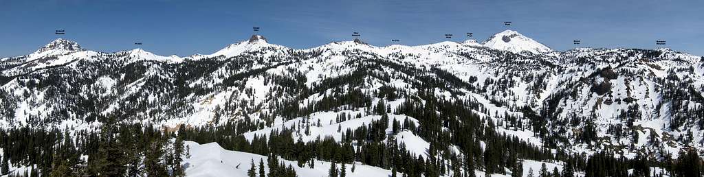
Diamond Peak is a small but striking summit located south of Lassen Peak and west of Brokeoff Mountain in Lassen Volcanic National Park. Despite its small size, the peak is easily noticed by most park visitors due to the prominent rock outcrops on the summit and the circuitous nature of the park road (Highway 89) as it wraps three quarters of the way around the peak. Diamond Peak can be climbed in less than a couple hours, requiring less than a half mile in summer and barely one and a half miles in winter. The accessibility makes Diamond Peak a popular winter daytrip destination, further enhanced by the excellent views that include the ridge stretching from Lassen Peak to Brokeoff Mountain, Mount Conard, Bumpass Mountain, and the surrounding geothermal areas.The peak is a plug dome remnant of the once much larger Mount Tehama which formed beginning 600,000 years ago over a period of 200,000 years and ultimately reaching a height of 11,000 feet. Once volcanic activity ceased, Mount Tehama was eroded by hydrothermal alteration and glacial action. Remains of the mountain also include Brokeoff Mountain, Mount Diller, Pilot Pinnacle, and Mount Conard as previous components of its caldera flanks. Lassen Peak itself, however, was not part of Mount Tehama (it is only 25,000 years old and a much more recent formation in the Lassen volcanic center). Sulphur Works, located one half mile west of Diamond Peak, is the primary remains of Mount Tehama’s main vent and contains excellent examples of fumaroles, mud pots, and bubbling 195° pools. Additional hydrothermal features also border the peak to the east in Little Hot Springs Valley.

Getting There
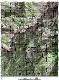 Area Map
 Sulphur Works
Diamond Peak is accessed from Highway 89 in Lassen Volcanic National Park, most commonly approached from either Highway 36 in Red Bluff or Highway 44 in Redding. In winter the approach from Red Bluff via the south entrance station is the only viable option due to park road closures. Highway 89 wraps three quarters of the way around Diamond Peak, and there are several pullout options (mostly on the downhill side of the road) available to begin the short hike.
Sulphur Works (40.44857° N, 121.53572° W)
From Interstate 5 in Red Bluff head east on Highway 36 for 45 miles to the Highway 89 junction south of the national park. From the junction, turn left and follow Highway 89 north for 5.5 miles to the visitor center. In winter and early spring the hike begins here at the road closure. Later in the season continue an additional three quarters of a mile to begin at the Sulphur Works parking area, or as much as an additional 2.5 miles further to begin at one of the turnouts on Highway 89 as it wraps around the peak.
Route
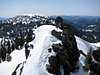
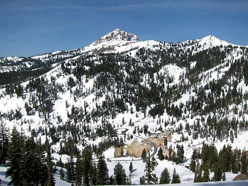 Brokeoff Mountain and Sulphur Works
Trip statistics from Southwest Visitor Center:
1.5 miles one-way, 1200 feet elevation gain out with negligible gain on the return
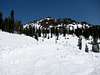
Diamond Peak is a popular winter/spring destination, as it remains very accessible from the Kohm Yah-mah-nee Visitor Center when the park road is gated shut for the season. From the visitor center you can either drop from the campground area down to Sulphur Creek and cross a footbridge to head directly to the peak, or more commonly parties snowshoe or ski up the road via Sulphur Works. Sulphur Works is reached on the road after three quarters of a mile and is a small but interesting concentration of sulfur deposits, fumaroles, mud pots, and bubbling pools of hot water. If visiting Diamond Peak when the park road is open, most will want to either begin here at the Sulphur Works or one of several pullout along Highway 89 near the peak.
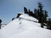
From just about anywhere on Highway 89 visitors can snowshoe, ski, or hike up the steep slopes to the summit (ice ax and crampons will typically be unnecessary for most individuals even in winter). The true summit is the northernmost rock outcrop at the top of the ridge, a large class 3 pinnacle that is much easier to mount than it initially appears. The route up is fairly obvious and proceeds easier than the initial somewhat awkward but unexposed move required to gain the base of the pinnacle (on my visit wet mountaineering boots were hardly an impediment and no special equipment is needed).
Red Tape
 Snowplows on Highway 89
Entrance Fees:
Diamond Peak is in Lassen Volcanic National Park and an entrance fee is required. Please see the Lassen Volcanic National Park fee page for full details.
Wilderness Permits:
Few will seek to make the short trip to Diamond Peak an overnight excursion, even in winter. If determined to do otherwise, however, see the Lassen Volcanic National Park wilderness camping page for regulations and details. There are no overnight quotas.
Lassen Volcanic National Park
P.O. Box 100
Mineral, California 96063
(530) 595-4480
Current Conditions
Current NOAA / National Weather Service ForecastLassen Volcanic National Park Road Conditions
Sierra Avalanche Center Daily Report
California Department of Water Resources Lower Lassen Peak Snow Data
When to Climb
This is a popular winter destination and the short trip to the peak can be done year round. Expect snow conditions from December until June, though the exact timing can vary.
 |
 |
 |
 |
 |
 |
Camping
 Lassen Peak and Little Hot Springs Valley
There are eight established campgrounds in Lassen Volcanic National Park, and many visitors will seek to utilize one of these options. The Southwest Walk-In Campground is the best option in winter when most other campgrounds are closed or inaccessible. During the summer and fall months both it and the other campgrounds along Highway 89 make for good camping locations. See the Lassen Volcanic National Park campgrounds page for more details.
Outside the park there are dozens of additional options for camping accommodations, ranging from primitive to full camping amenities. Dispersed camping is permitted near the park in bordering Lassen National Forest. The national forest also has plenty of campgrounds available, see the Lassen National Forest camping page for additional information (note that topo maps will show some primitive camping sites not listed on the national forest website).