
-
 15253 Hits
-
 80.49% Score
-
 12 Votes
|
|
Mountain/Rock |
|---|---|
|
|
45.16651°N / 109.81317°W |
|
|
Hiking, Mountaineering, Scrambling |
|
|
Spring, Summer, Fall, Winter |
|
|
12745 ft / 3885 m |
|
|
Overview
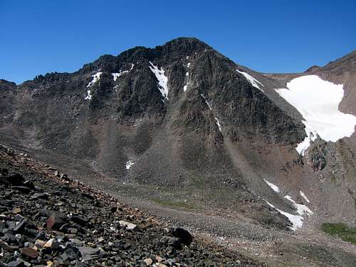
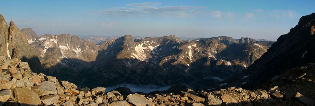
Point 12,745, also known as "West Granite Peak" is a ranked 12,000 foot peak in the Montana Beartooth Mountains and is a worthy objective as the views of the north faces of Mount Villard and Glacier Peak are quite impressive. This lofty perch is the second highest point in Montana but is rarely climbed due to the state highpoint being right next door. Having an approach just as long as Granite Peak, it is likely only climbed by those seeking to climb all the 12ers in Montana. With 325 feet of clean prominence to Granite Peak, it rises far enough above the connecting saddle to be considered a separate peak by some climbers, however many disregard it as a mere sub-summit. No matter what your view is, it is a worthy trip.
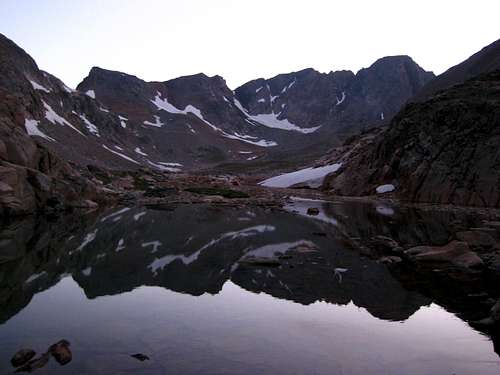 West Granite Peak on the left from Sky Top Lakes | 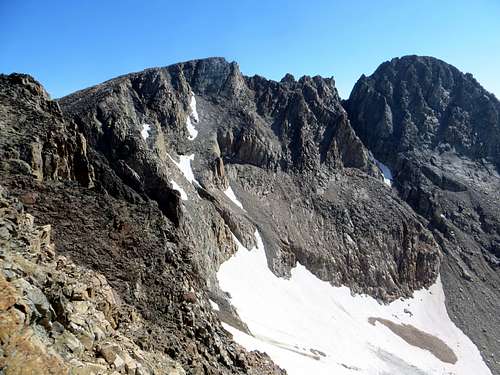 West Granite on the left with the traverse to Granite |
Getting There
So there are two primary ways to get to West Granite Peak...either from the north or the south. If you approach from the north you will need to use the West Rosebud (Mystic Lake Trailhead) and hike up the Huckleberry Creek Route. If coming from the south you need to use the Lower or Upper Aero Lakes Trailhead and hike past Aero Lakes and into the Sky Top Lakes drainage. See below for a detailed description for these approaches.
WEST ROSEBUD (MYSTIC LAKE) TRAILHEAD
The West Rosebud Trailhead is located approximately 80 miles southwest of Billings. To reach the trailhead, take the Columbus exit from Interstate 90, and take Montana Highway 78 through Absaroka and turn west (right) toward Fishtail (approximately 17 miles from Columbus). From Fishtail, drive west and south for 1 mile and turn south (left) on West Rosebud Road. Follow this paved road for 6.3 miles until reaching a fork in the road and a large brown Forest Service sign. The sign will indicate West Rosebud Lake Road #2072. Turn left here and follow the dirt road for 14.4 miles until reaching the trailhead. The trailhead has toilet facilities, and a large parking area. Please obey the posted private property signs and do not drive beyond the trailhead parking area.
The trail actually begins up the road about 200 yards, and is reached by walking through the Montana Power Company facilities where the trailhead is clearly marked with a Forest Service sign. From there, the trail leads up toward 7,637 foot Mystic Lake, one of the most popular day hikes in the Custer National Forest. The trail is relatively flat for about the first two miles, leading to switchbacks that eventually bring the hiker to a point looking over Mystic Lake Dam. The total elevation gain is about 1,200 feet over 3 miles. Once at the dam overlook, descend down to Mystic Lake and continue hiking for a half mile until reaching an intersection for the Phantom Creek Trail #17 branching to the left (south). Stay on the trail along Mystic Lake for an additional 2 miles until you cross Huckleberry Creek on a nice bridge near the west end of the lake (5.75 miles from the TH).
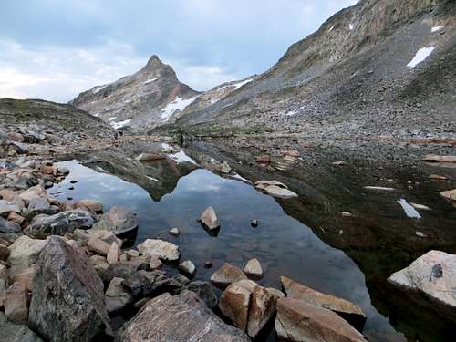
HUCKLEBERRY CREEK APPROACH ROUTE - STORM LAKESAfter crossing Huckleberry Creek on the footbridge, follow a faint climbers trail up and along Huckleberry Creek, leading you in a southerly direction, up and out of the Mystic Lake basin. This section to Huckleberry Lake is fairly steep, but easy to follow. The climbers trail is fairly well established and keeps you to the right (west) side of Huckleberry Creek. You will not see the creek again until almost reaching Huckleberry Lake. At Huckleberry Lake, 1 mile from Mystic Lake at 8,370 feet, you reach the first boulder field. There are a few cairns leading you through the middle of the boulders and it is the best route we found. If you miss the cairns right away, descend a little and follow right along the lake shore. At the end of the boulderfield, pick up the climbers trail and continue towards Princess Lake. The section leading to Princess Lake involves a sustained climb through the timber on a trail that can be easy to lose at times. The trail will top out over-looking Princess Lake at 9,100 feet. Once Princess Lake comes into view the trail will split. This is where you need to decide if you are going to get to Avalanche Lake via Snowball Lakes or Cold Lake. For an ascent of West Granite Peak do not continue to Cold Lake but continue around the west side of the lake staying close to the lake shore to avoid intense bushwhacking. Reach the base of a large waterfall and make a steep 500 foot ascent on trail and talus to the right side of the waterfall. Reach the lowest Snowball Lake and hike around its right (west) side and continue up passing the second and third Snowball Lakes. Reach the 4th and highest Snowball Lake at 9,780 feet and hike around it on the left side. Continue south up talus passing to the right of 10,875 foot Storm Spire. Hike up a short, steep gully and slabs for 400 feet to a small 10,560 foot saddle which is 2.3 miles from Princess Lake. Continue south around the west and south sides of Lower Storm Lake and cross its inlet stream. Follow it up to Upper Storm Lake where the approach ends.
 Mystic Lake from the Huckleberry Creek bridge | 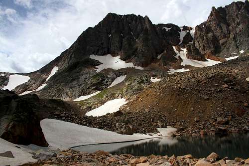 Mystic Mountain from Upper Snowball Lake |
LOWER AERO LAKES TRAILHEAD
Starting from Cooke City Montana, head east on US 212 for 1.6 miles to the signed turnoff for Lulu Pass. Turn north on this good gravel road and measure from this point. Follow it for 1.1 miles to a 3 way fork and continue up the middle fork. Stay right at 1.8 miles and reach the signed Goose Lake Junction after 2.4 miles. It is best to park low clearance passenger cars here off the road. There is a very large open area surrounding this large junction. If you have a higher clearance tough car or a 4 wheel drive vehicle, you can continue further. From the Goose Lake Junction make a sharp right turn on a small side road (don’t continue to Lulu Pass or Goose Lake). Follow this rough and highly rutted side road for 0.3 mile to the trailhead at 8,850 feet in elevation where the road ends. A very old mining shed and minding junk can be found here so be careful where you drive and park and watch for sharp objects just waiting to eat your tires! If you have a high clearance 4 wheel drive vehicle, you can continue to the upper trailhead. From the signed Goose Lake Junction, continue up the rough road towards Goose Lake. Pass by Mud Lake and continue 0.3 mile past Round Lake to the trailhead just off the road at 9,420 feet in elevation. A trail descends about 500 feet to the main Aero Lakes trail from here.
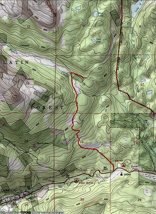 Lulu Pass Road to the Trailhead | 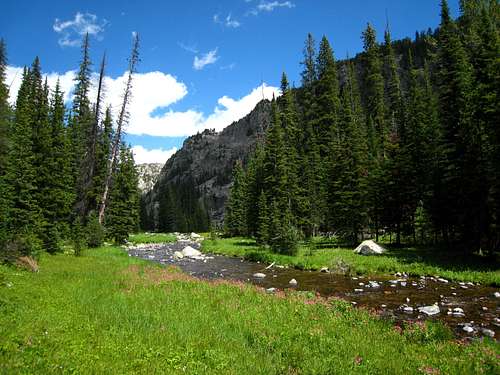 Hiking along Zimmer Creek |
AERO LAKES APPROACH ROUTE
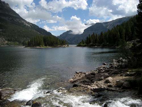
From the lower trailhead, there is a large cabin nearby just to the east. Walk around it on the left side (passing an old hot water heater) and cross a small stream on some boards or rocks. Emerge on the trail after a few feet of bushwhacking and walk northeast on the trail passing a large sign for Lady of the Lake. The first part of the trail heads up a short steep section and mellows to a nice undulating hike through sparse forests reaching the south end of Lado of the Lake at 8,750 feet after 1.5 miles. Follow the trail around the west side of this large lake (with great fishing and camping) and reach the junction with the trail coming down from the upper trailhead after another mile. A large cairn marks this junction. Continue straight and pass around a large meadow and cross a small creek which flows back down to Lady of the Lake. Don't follow this creek as it curves back to the south. Utilize rocks and logs to get across, then stay on the trail heading up another short section and staying left 0.5 mile from the creek crossing. A few logs block another trail heading straight. Your first views of Mount Zimmer and Iceberg Peak are found here to the north. After a few more minutes of hiking, cross Star Creek where it dumps into Zimmer Creek and continue up the trail which follows the west side of Zimmer Creek for another mile. When the trail once again reaches the creek side, cross it on a couple large logs at 9,150 feet and locate the trail heading northeast towards Aero Lakes. This junction is unsigned so don't miss it and continue up Zimmer Creek. This trail quickly begins to climb steeply for 900 feet reaching Lower Aero Lake after another 1.1 miles at 10,000 feet. The final quarter mile to the lower lake is hard to follow, just follow large talus through an obvious gap and descend 50 feet to the lake shore. This is where the official trail ends (5.4 miles from the TH) but a boot path heads west around the lake, reaching its southwest corner after 0.3 miles which has a nice calm area making for great fishing. Continue along the northwest shore for another 0.9 miles and reach a small stream coming down from the northwest which drains a small lake above and to the north. Descend 50 feet to the creek, cross to its east side, and follow this drainage up to a very broad 10,160 foot saddle. Descend a short ways to the upper lake outlet stream and find a place to cross it. Wading may be required in early season. Reach the Upper lake at 10,170 feet and hike east around its south shore, then north around the east shore for 1.3 miles from the outlet. Stay close to the shore on the east side to avoid annoying talus traversing. Begin an ascending traverse and cross a small stream reaching a small tarn at 10,330 feet (200 feet above Upper Aero Lake). The camping at this tarn is fantastic and out of the bugs that flock the lake shore below. Views of Glacier, Villard, the Spires and the upper lake below are out of this world! This beautiful spot is 3.3 miles from where the official trail ends making the total distance 8.7 miles from the trailhead with only a 1,500 foot net elevation gain.
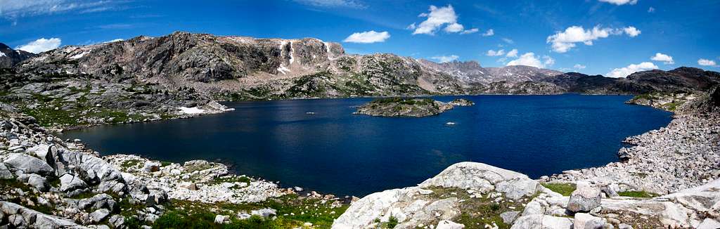
Lower Aero Lake Panorama
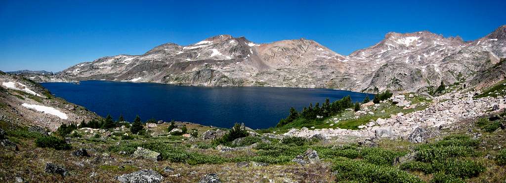
Upper Aero Lake Panorama
Standard Route - West Face/Southwest Ridge Class 2
WEST FACE
This route is used if you are approaching via the Huckleberry Creek Approach from the north. From Upper Storm Lake at the end of the Huckleberry Creek approach, hike around the east side of the lake and begin hiking straight up the steep talus on the west face of West granite Peak at 10,600 feet. This is a long 2,100 feet as the talus is loose in spots. There really isn't any difficulties to this route and it never exceeds Class 2 however an ice axe and/or crampons will be needed in early season. Since this is a west facing slope it tends to be completely melted out by the middle of July.
Looking across Storm Lakes valley from the west slops
SOUTHWEST RIDGE
This route is used if you are approaching via the Aero Lakes approach from the south OR if you are making the Class 3 Mystic Mountain to Granite West traverse. From the nice camp just above Upper Aero Lake, hike northeast up talus or easy snow for 0.8 miles to a broad 10,835 foot saddle between Point 11,379 and The Spires. Descend a short ways and contour left (north) down talus or moderate snow and reach the north end of Lower Sky Top Lake 0.6 mile from the saddle at 10,475 feet. There is another awesome place to camp in a small grassy area here. Continue hiking up gentle terrain around the right (east) side of the upper lakes for 1 mile to a small, 10,610 foot flat bench right before the terrain steepens. You are aiming for the broad 11,500 foot saddle north of Mount Villard. Ascend a grassy rib, then up a 200 foot talus moraine to 10,850 feet and continue up easy to moderate snow to the saddle. Turn right and contour around to the left (west) side of an unnamed point just north of the saddle and hike up talus towards the southwest ridge. Reach the ridge crest just above 12,000 feet and continue on or just to the left side of the crest for 1.25 miles to the summit. There are a few sections on the ridge you will have to drop and scramble around but if you stay on the left side of the ridge for these sections you can keep the difficulty at Class 2+
 Looking back at Point 11,379 and the crossover saddle from Sky Top Lakes | 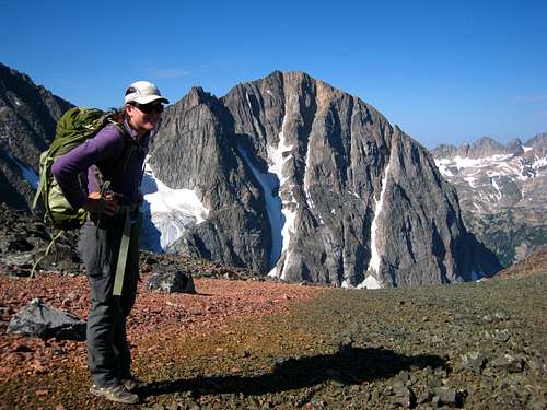 North face of Glacier Peak from the 11,500 foot broad saddle | 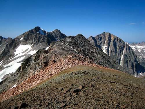 Glacier Peak and Mount Villard from the SW ridge |
Sunrise over the western Beartooths from the 11,500 foot saddle north of Mount Villard
Map
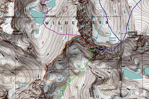
DARK BLUE: Granite Peak East Ridge - Class 4
LIGHT BLUE: Granite Peak Notch Couloir - Class 5.4 and Steep Snow
GREEN: Granite Peak Southwest Couloir - Class 3
RED: West Granite to Granite Peak Traverse - Class 5.4
ORANGE: West Granite Peak Southwest Ridge - Class 2+
PURPLE: West Granite Peak West Face - Class 2
When to Climb
Summer climbing in the Montana Beartooth Mountains runs from mid-June through September or early October. Typically the spring snows melt out enough on south and west facing slopes by the end of June and the first big snowfall of the season occurs by early October. Fall makes for an awesome time to climb in the Beartooths with the vibrant foliage found everywhere. Winter brings lots of snow, wind and very cold temperatures, in addition to near impossible access to most of the trailheads. The Beartooth Pass also closes from the middle of October through May. Check the Ranger Station in Red Lodge for current snow and fire conditions as well as any restrictions that may be in place.
Beartooth Ranger District
6811 U.S. 212, Red Lodge, Mt 59068
(406) 446-2103
Camping/Red Tape
Aero Lakes Approach:
Excellent camping can be found at the small tarn just above Upper Aero Lake, as well as at the north end of Lower Sky Top Lake. Beautiful camping can also be found anywhere around Lower Aero Lake but this may be too far away from the peak to be of use to any ascent party.
Huckleberry Creek/Storm Lakes Approach:
The best place to camp on this approach is at Princess Lake. This makes for a very scenic and doable single day approach and the fishing here is perfect! Other places one could camp is at one of the Snowball Lakes or on a tiny meadow patch at Lower Storm Lake. There are no good places to camp at Huckleberry Lake.
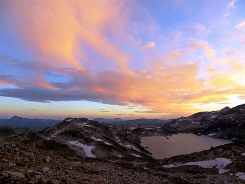
Upper Aero Lake at sunset