Page Type Page Type: Mountain/Rock
Location Lat/Lon: 42.05126°N / 73.48214°W
Activities Activities: Hiking
Seasons Season: Summer
Additional Information Elevation: 2450 ft / 747 m
Sign the Climber's Log

Overview

Often overlooked, Mount Frissell, located in Massachusetts but right on the state border of Connecticut, is generally summited "on the way" to the Connecticut state high point. The trail coming in from Connecticut is not easy to find but once you are on it, it is to follow. Coming up over Round Mountain you'll find great views before climbing steeply down and then steeply back up and into Massachusetts. 

Getting There

Take SR 22 in New York to Rt 344. Head East on 344 and follow the road past Bash Bish Falls State Park. Where the road dead-ends make a right on Mount Washington Road (also known as West St. This turns into a dirt road, continue straight until you pass the cement Massachusetts/Connecticut state line marker on the left side of the road and park in the AMC parking lot shortly after this marker (also on the left side of the road). From the south: In Salisbury, CT, go west on US 44 until you get to Factory St. Turn right, then bear to the right onto Mt. Riga Rd. Mt. Riga road turns into a dirt road and continues a few of miles. Once you reach Mt. Washington Road, turn right and go 3.3 miles to the AMC parking lot on the left.
Mount Frissell Map
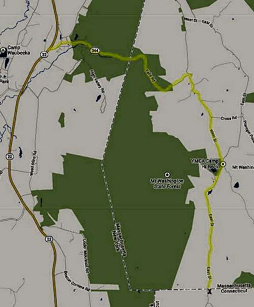
How to Get to Mount Frissell, Connecticut

Route

From the parking lot, walk north along the road past the state line marker and turn left onto an old gravel and stone path/road. You will see a trail that turns left from this old path/road. The trail is marked with red blazes on both the trees and rocks and is relatively easy to follow. It ascends steeply up to Round Mountain where you will find panoramic views south and east into Connecticut, north into Massachusetts and west into New York. To the north Mt. Frissell can be seen. You must descend and then climb steeply back up into Massachusetts and to where the trail divides. Heading to the right and traveling a hundred feet will take you to the summit of Mt. Frissell. There is a small yellow sign hanging on a tree as well as a canister with the register. If you are heading for the Connecticut state high point, you must head back to where the trail divides and head southwest to the Southern Slope.

Red Tape

Add Red Tape text here.

When to Climb

Usually climbed in the Spring, Summer and Fall. Winter may require equipment such as crampons.

Camping

There is camping at nearby Bish Bash Falls.

External Links

Add External Links text here.


Parents 

Parents

Parents refers to a larger category under which an object falls. For example, theAconcagua mountain page has the 'Aconcagua Group' and the 'Seven Summits' asparents and is a parent itself to many routes, photos, and Trip Reports.

Taconic MountainsMountains & Rocks