
|
|
Mountain/Rock |
|---|---|
|
|
37.22797°N / 113.66358°W |
|
|
Download GPX » View Route on Map |
|
|
Washington |
|
|
Scrambling |
|
|
Spring, Summer, Fall, Winter |
|
|
4300 ft / 1311 m |
|
|
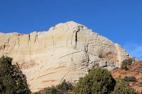
Overview
Little Angel (my name for it -- I seriously doubt this obscure, off-the-beaten-path peak has an official title) is a spectacular peak when viewed from the right angle. From most of the trailheads this crag is either completely invisible or blends in with the walls to its west. However, when viewed from the West Canyon trail (the northern end,) it is an overwhelming, towering sight. The route up the north ridge is, for the most part, a steep scramble, but has one 5th class hand crack that should be taken seriously. Downclimbing it is a dicey proposition (as I learned the hard way.)
Getting There
From the Desert Rat outdoor retail store (corner of St. George blvd. and Bluff St.,) drive north on Bluff for 1.7 miles. Turn left onto Snow Canyon Parkway (making sure you stay on the inside lanes and not going on the overpass) and drive northwest for 3.9 miles (continuing through the first traffic circle.) At the second traffic circle, take the first right onto Snow Canyon Drive. Continue north for one mile to the South Entrance to Snow Canyon State Park. Pay the $6 toll and drive for another 3.2 miles to the Lave Flow Trail. Hike the Lava Flow Trail for 1.5 miles to its junction with the West Canyon Road. Head north on the gravel road for a little over a mile. When the road bends to the west you will reach a fork. Take the left hand fork towards a pump house. Continue west down the road past the building to the end of the road. An obvious trail continues west. Follow this trail through sage and sand until you reach the obvious base of the ridge. Total distance from the fork in the road to the ridge is about .3 miles. Total distance from the trailhead is about 3 miles.
Route
North Ridge: From the toe of the ridge, begin climbing up the rightmost ridge for 40 or 50 feet, then traverse over to the left ridge. The climbing, by and large, is just a steep class 2 and 3 scramble with occasional class 3 sections. There are probably numerous options for climbing the north ridge; I happened to take the eastern rib, so I will only describe what I know. About halfway up the rib, steeper terrain will be encountered. There are a series of vertical, but easy 3rd class steps. Eventually a much steeper steps is reached. The crux is a ten-foot high hand crack with an overhang above it. When I climbed up this crack I felt it was 4th class. When I descended it I felt like it was definitely low 5th. In either case, a rappel on descent might be wiser than downclimbing it.
Above the crux a short brushy section is passed, and right above this there is a "cave." Climb above it on the left. Once on top of this, a gap to the right must be crossed. It was easy enough to jump across, but on my return found it was much easier to find a spot to cross over a little ways below.
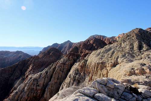
At this point you are on a broad face, and the angle mellows considerably. The last few hundred feet to the summit consists of blocks and slabs, and the route variations are endless. Use your best judgement and the difficulty should never exceed easy class 3. Soon the fine summit is reached, with absolutely stunning views in all directions.
Descent: Return the way you came. However, I diverted from the gap I jumped over, descended below it and found an easier spot to cross over to the easternmost rib. When I reached the crux, at first I thought I had gotten off-route, but then realized that no, I was in the right spot, but downclimbing the crack looked significantly harder, and it was. I had to lower my pack past the overhang, awkwardly put it back on and then very gingerly downclimb the handcrack, never really certain where I was putting my feet. I was incredibly relieved when I was safely past that section. A short rope and some slings are highly recommended.
 Little Angel | 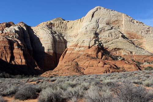 Little Angel |
 Little Angel | 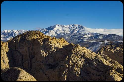 Little Angel |
Red Tape
There is a $6 fee to enter Snow Canyon State Park.
When to Climb
Winter, Spring and Fall are ideal. Summer would be excruciating except in the early morning and late evening.Camping
Snow Canyon has an excellent campground. Dispersed camping on BLM and Forest Service land is an option, the closest available spots are north of the park. There is nice camping spot at the base of the Prophecy Wall near Veyo.Necessary Gear
Hiking shoes, food & water, short rope and slings, camera, GPSExternal Links
Ivins weather.
Snow Canyon State Park PDF brochure.