
|
|
Mountain/Rock |
|---|---|
|
|
36.37536°N / 50.96128°E |
|
|
Kelardasht, Sehezar |
|
|
Hiking, Bouldering, Ice Climbing, Big Wall, Mixed, Scrambling |
|
|
Summer |
|
|
15912 ft / 4850 m |
|
|
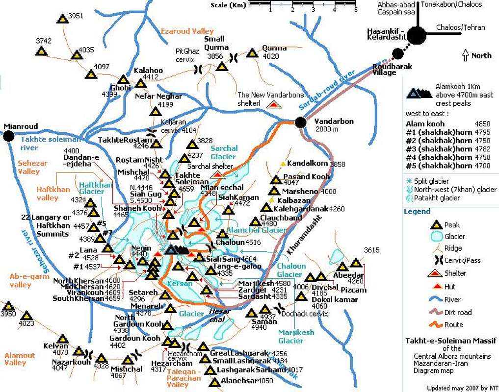
Overview
Click for Introduction to Central Alborz Mountains
Click for Introduction to Takhte Soleyman Massif
Click for Nader's map of Takhte Soleyman Massif
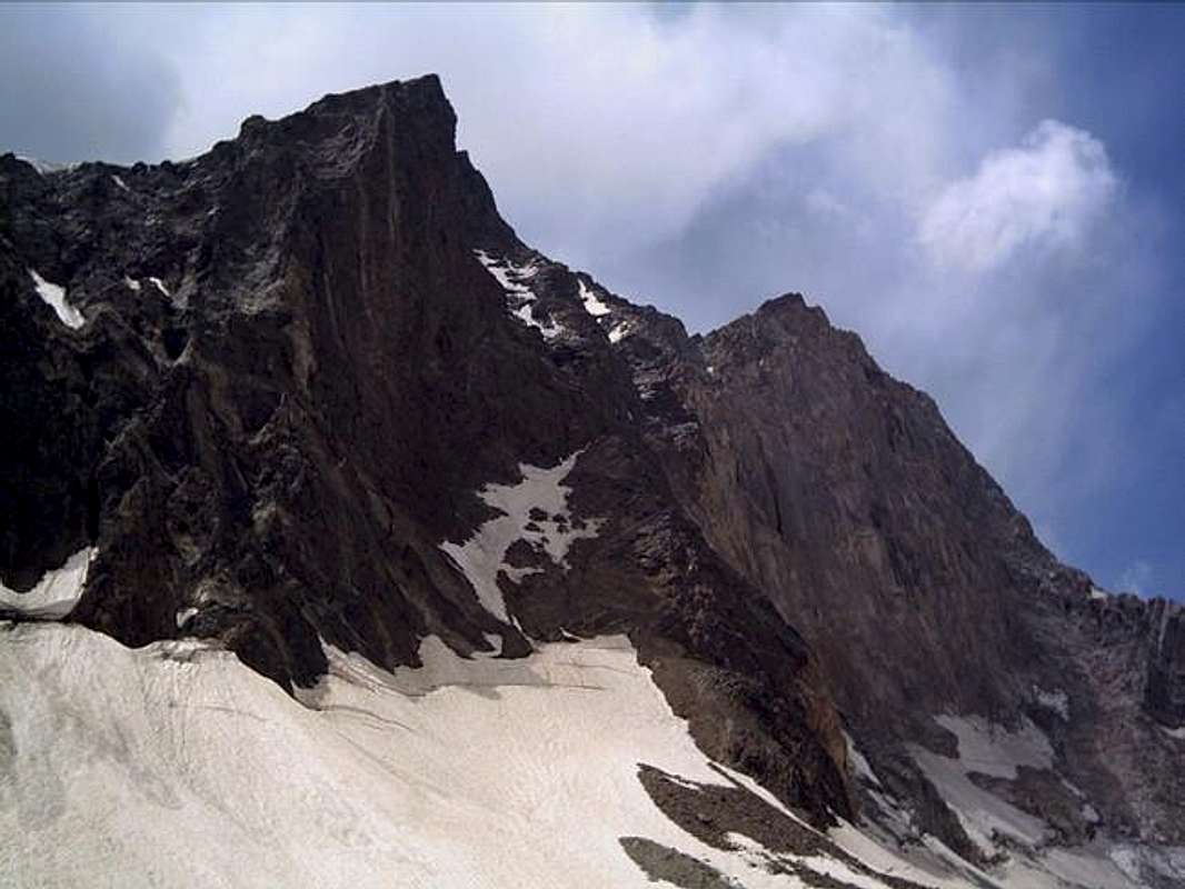
| North wall (right) - the left wall and peak is one of the Shakhak horns: | ||||||||||||||||||||||||||||||||||||||||||||||||||||||||||||||||||||||||||||||||||||||||||
 [by] [by] |
||||||||||||||||||||||||||||||||||||||||||||||||||||||||||||||||||||||||||||||||||||||||||
| Notes | ||||||||||||||||||||||||||||||||||||||||||||||||||||||||||||||||||||||||||||||||||||||||||
|
Alam Kooh is the second highest peak in Iran ! (Damavand(5671m) is the first and Sabalan(4811m) is the third). Alam Kooh is sometimes been written as : "Alamkouh", "Alamkoh", "Alamkuh", "Alamkooh" or "Alam kouh". The north face (a little toward north-west) is actually a giant vertical wall. This wall and impression of climbing it, is what makes Alamkooh famous and demanded for Iranian climbers, these are some correct details about the wall : Anyway Alam Kooh wall fame is not for being the tallest wall of Iran and it isn't, but the fame is for being the wall having the highest altitude at base and peak I mean no other wall in Iran is located on a higher place than Alam Kooh wall. |
||||||||||||||||||||||||||||||||||||||||||||||||||||||||||||||||||||||||||||||||||||||||||
| History | ||||||||||||||||||||||||||||||||||||||||||||||||||||||||||||||||||||||||||||||||||||||||||
| The Takht-e-Soleiman region was unknown until 1933. Douglas Busk, a British mountaineer, discovered and surveyed the area. Later on, Busk along with Professor Bobek made a detailed survey of this area. In 1936 the north-west ridge (called Germans flank) of Alam Kooh was climbed for the first time by German mountaineers, which was considered a great achievement among European climbers. |
||||||||||||||||||||||||||||||||||||||||||||||||||||||||||||||||||||||||||||||||||||||||||
| Topography and location | ||||||||||||||||||||||||||||||||||||||||||||||||||||||||||||||||||||||||||||||||||||||||||
Alam Kooh is the tallest needle located at the heart of Takht-e-Soleiman massif, actually at the joint point of the following ridgelines:
Surrounded by:
|
||||||||||||||||||||||||||||||||||||||||||||||||||||||||||||||||||||||||||||||||||||||||||
| General information | ||||||||||||||||||||||||||||||||||||||||||||||||||||||||||||||||||||||||||||||||||||||||||
| Geological map of Iran it shows that Alam Kooh is mainly made of tertiary intrusive rocks; granite and diorite. Some Triassic and Jurassic sediments are also found. The gigantic rocky block in the heart of Takht-e-Soleiman massif makes a one km long ragged east-west running ridgeline that is entirely above 4700m, the western one quarter of the ridgeline makes the Alam Kooh section including the 4850m Alam Kooh peak, and the eastern part makes five horn shaped peaks known as Shakhak#1~ Shakhak#5, the north face of this block creates vertical walls of Alam Kooh and Shakhak (there is a perfect 350m wall under the summit of Shakhak#5 sometimes it can be seen even more impressive than Alam Kooh wall in some pictures) which have the height range between 350m and 600m(including steep glacier). Climbing Alam Kooh via all north routes are class five high altitude technical climbs which need hard struggling with rock, ice and rock falls but the southern slopes of Alam Kooh and the Shakhaks are steep covered with boulders and/or scree and they form Khersan and Marjikesh glaciers. the southern routes are easy class three climbs at summer. Anyway climbing Alam Kooh by any route at winter is difficult and technical. |
||||||||||||||||||||||||||||||||||||||||||||||||||||||||||||||||||||||||||||||||||||||||||
| Routes Introduce | ||||||||||||||||||||||||||||||||||||||||||||||||||||||||||||||||||||||||||||||||||||||||||
|
||||||||||||||||||||||||||||||||||||||||||||||||||||||||||||||||||||||||||||||||||||||||||
| See Nader's four exelect shots of Alam Kooh north and south faces (Alam Kooh Shakhak #1 page) | ||||||||||||||||||||||||||||||||||||||||||||||||||||||||||||||||||||||||||||||||||||||||||
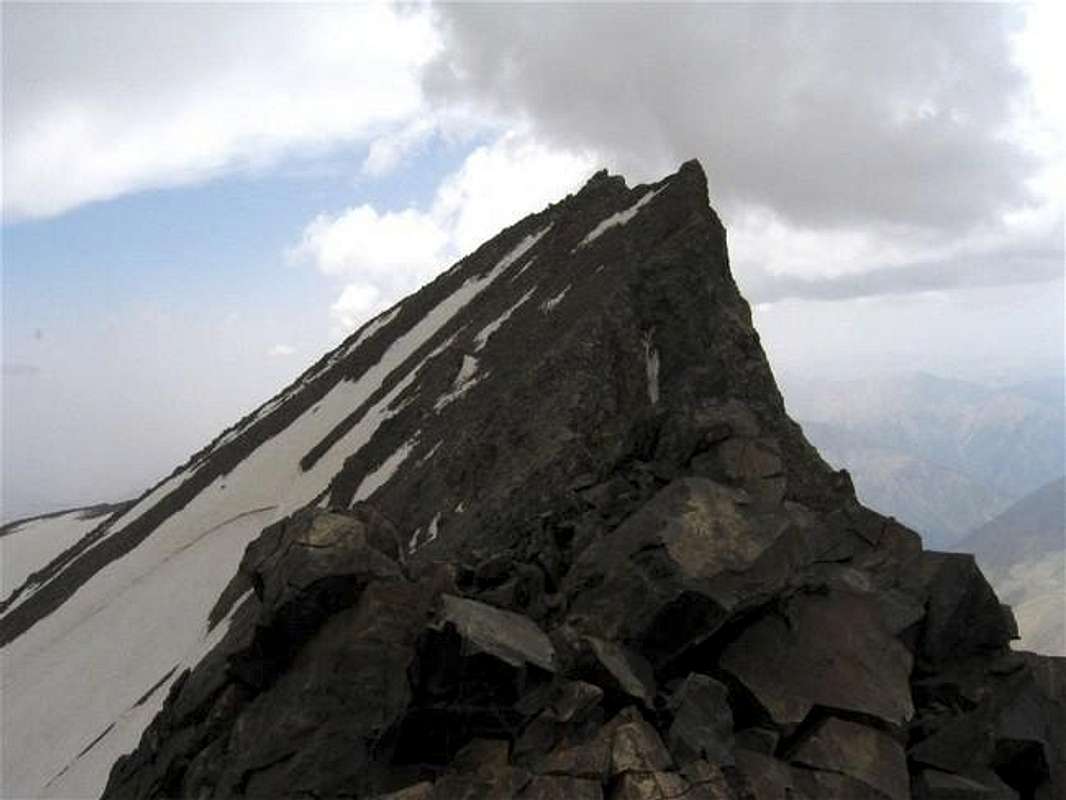
Looking west to Alam Kooh summit: |
||||||||||||||||||||||||||||||||||||||||||||||||||||||||||||||||||||||||||||||||||||||||||
 [by] [by]I like it when it comes to views that show a peak in it's most precious face, pictures taken from outside of the mountain and views that everyone can see, about Alamkooh unlike the 3964m Tochal that is viewable from almost every possible and even impossible place Alamkooh peak can only be seen from very far high places as the tallest point in a vast massif, It's hard to see Alamkooh clearly from Kelardasht and nearby areas, bellow is one of those rare chances, this picture is too small to give the feelings, unlike most soft Iranian peaks that look easy, looking at these peaks from Kelardasht, they look like fearsome ragged granite monsters specially the black giant Alamkooh wall that is out of snow: Jan 2005: Siahkaman(4472m) middle - Alamkouh(4850m) is the black stone behind Siahkaman - Germans flank - Shanehkouh(4465m) and a portent electricity wire I forgot to remove with Photoshop. 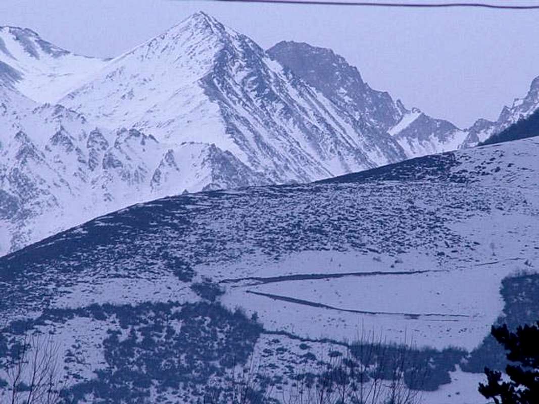 |
||||||||||||||||||||||||||||||||||||||||||||||||||||||||||||||||||||||||||||||||||||||||||
Getting There
| Vandorbon | [this is for the recommended and traditional climbs to see all climbing ways in start point section of Takht-e-Soleiman massif page] Tehran -> Karaj (by a 30Km highway) -> Karaj-Chalous road 24Km before Chalous at Marzanabad village turn left toward Kelardasht -> Hasankif -> Roudbarak village(1400m) -> at the end of Roudbarak there is a dirt road, after about 8Km(40minutes by car) it reaches Vandarbon(2100m) now choose to climb south face or north face : |
| South face | Enter the route to Sarchal glacier (right branch, anyway a sign there shows the way) |
| North Wall | Enter the route to Hesarchal (left branch, anyway a sign there shows the way) |
Red Tapes and Regional Hints
| The whole Alborz mountains area and it's wild nature is a protected place, hunting, fishing and abusing the nature is prohibited |
| No fees of permission is required for climbing or camping |
| No problem for camping but avalanche danger and rockfalls ! |
|
Karaj-Chalous road becomes 1way at 6.30pm on summer Fridays and Iranian holidays so cars can only drive to Tehran. |
| Numerous rock falls and avalanches, frostbite, getting lost, wild animals... ! so get enough prepared and informed about the region by the locals specially at 'Roudbarak Iran Federation of Mountaineering Hotel(IFM)' or hire a local to come with you. |
| Report your entrance to the region and the time you want to spend on the massif to the 'Roudbarak Iran Federation of Mountaineering Hotel (IFM)' or the locals before performing a climb, so they would send rescue if you are late. get enough details from them too ! |
When to Climb
| Best | June to October. |
| Photography | Always. |
| Summer | Ideal for climbing and camping be ware of the rockfalls. |
| Winter | Climbing Alamkooh in winter by each route is hard and dangerous. |
Mountain Conditions
| Summer (June-October) | Some years like 2005 June is still winter for Alamkooh, and winter conditions still appear like deep snow, snow falls and coldness. Weather is clear, isolated thunderstorms occur, precipitation will be snow or sleet in high elevations. Even precipitation in summer may cause avalanche, numerous rock falls occur all the day and serious rock falls occur sometimes (specially on Germans flank) and they will last for minutes with a fearsome crashing sound. |
| Winter | Heavy snow, frequent snow storms + wild wind that usually continue 7~10 days, very low temperature specially on the north side. |
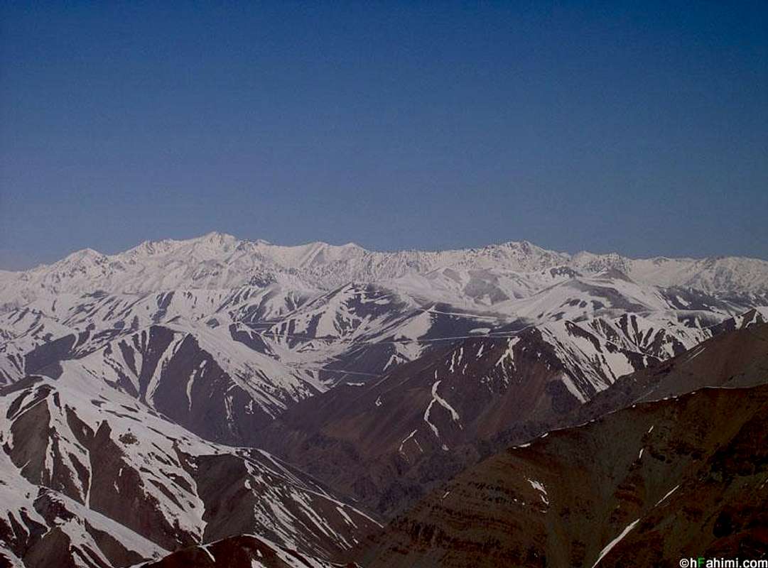
West face of Alamkooh and Takht-e-Soleiman massif.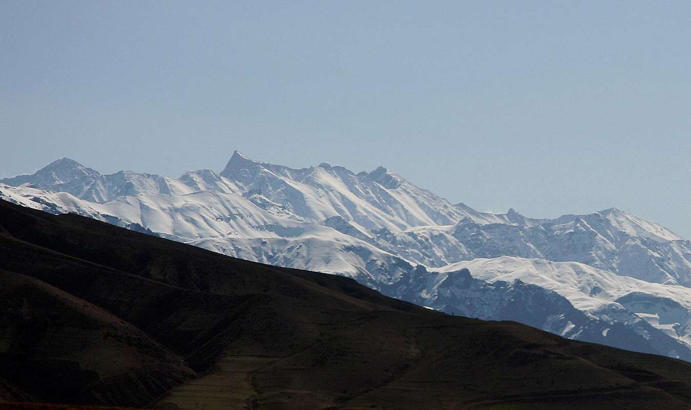
A fine picture showing Takht-e-Soleiman massif south face, early spring. Alamkooh is the highest point in the center.
Picture taken at Dizin Ski resort "Upper parking" (3200m) and about 80Km far.
Casas - Aug 10, 2016 12:53 am - Hasn't voted
Fee or permit for foreignersAugust 2016. I was in the new hut after Roodbarak, without guide or tour, and I was told that I had to pay a permit of 30$ or 1000000IRR to climb Alam kooh. After much discussion about this stupid discrimination (iranions pay NOTHING) and arguing about where was the money collected this way going to end, I paid under police calls threats. My advice is, if you don't want to pay the fee, enter the valleys that lead to hesarchal (south slopes of alam kooh) or sarchal (to climb through the north face) without being seen, either very early in the morning when the guard sleeps or late in the night after 11pm. Be aware that if you come with your own car this means you are not going to be able to park inside the hut, as it is usual, but you can park after, even the path is not good and lots of goats and sheep will caress your car.
gregorioinvrea - Jan 11, 2017 7:57 am - Hasn't voted
Climbs in Elburz 60 years agoI was in Alam Kooh group in august 1957 with three other italian friends. We climbed Siah Kaman and Chaloon by iranian routes, and Takt-i-Suleiman, Chane Kooh, Alam Kooh,Kersan 1&2 probably by new routes. In addition we tried a new route on the NW face of Alam kooh and were rejected by a strong Storm, after not more than 200 meters, difficulty from 3° to 5°. I notice that this activity is not mentioned in the list of ascents in your site. Have anybody a comment or explanation ? Thanks, Gregorio Invrea