
-
 70727 Hits
-
 92.1% Score
-
 40 Votes
|
|
Mountain/Rock |
|---|---|
|
|
47.99074°N / 121.47058°W |
|
|
Download GPX » View Route on Map |
|
|
Snohomish |
|
|
6613 ft / 2016 m |
|
|
Overview
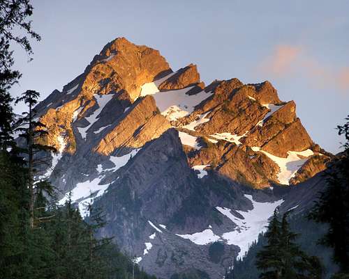
The North face of Del Campo seen August 11, 2008
Starting Point: Barlow Pass (2400')
Mid Point: Foggy Lake (5200')
Summit Elevation: Del Campo Peak (6613')
Round Trip Distance: 11 miles
Summit pinnacle: Class 3 - 4 Rock Scrambling
The Standard Route
Depending on the year, the trail to Gothic Basin should be clear and easy to follow to its end at Foggy Lake by the end of July. Make sure to bring a map and compass especially earlier in the season when snow makes the upper trail impossible to follow. The trail peters out when you reach Gothic Basin. There are several smaller tarns just below Foggy Lake that sometimes cause some confusion. You will know you have found Foggy by the large size of it. At the widest aspect it is about one third of a mile wide.
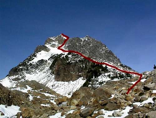 The standard route from Foggy Lake
From Foggy Lake the next step is to gain the southwest ridge. One way to do this is to follow the east shore to a small pond that is oblong and runs off to a ridge, then up the southwest ridge. From the top of the ridge, ascend the permanent snow field (axes highly recommended) on the south slope. Rock and snow go up to an obvious notch between the South Buttress and the summit of Del Campo Peak. Ascend class 3 and 4 rock just left of the obvious gully leading to the notch. From the top of the snowfield, the gully looks like the easier way but you will encounter a vertical wall if you go this way. This is one of those cases when the way that looks harder is actually easier. After about 150 feet of scrambling the route gains the east face and scrambling continues westward. From here it is not far.
There are other routes that start from the base of Del Campo (Foggy lake) that Beckey describes, so please refer to his book for other options.
Getting There
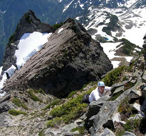
The final scramble below the summit
Directions:
Follow the Mountain Loop Highway from Granite Falls 30 miles, all the way to Barlow Pass (elevation 2400 feet), right across the street from the Goat Lake trail head. Park near the pullout and gate. Hike the Monte Cristo Road for about one mile (please see the red tape section wash-out details) to the South Fork Sauk River crossing where the Weden Creek Trail (FST 724) begins. Some folks will prefer to use a bicycle on this old road.
FST 724 starts out gently as it follows Weden Creek for about three quarters of a mile with no elevation gain, then becomes moderately steep as it climbs the wooded slopes. At about 3700', the trail begins a long traverse to the south and trail conditions begin to deteriorate about a mile before the trail ends in Gothic Basin. The maintained trail ends at a pond, but continuing beyond is worth the effort
From the pond, travel NW on rock and snow for about a quarter of a mile to the outlet of Foggy Lake. There were some cairns that were somewhat sporadically placed, but do not use as guidelines as some go to Gothic Peak, and some to Del Campo. Stay to the right of Foggy Lake to ascend the standard route for Del Campo.
Red Tape
 |
NW Forest Pass required at Trail head (Barlow Pass)
The Monte Cristo road is now gated adding one mile each way to the hike. The road is washed out in two places and there are large mud/clay slides to cross before reaching the trail head. Exercise caution when crossing and beware of loose ground. There is a new trail forming that skirts a larger section of the damage.
DO NOT DRINK any water from the South fork of the Sauk River or Weden Creek Basin. There are warnings posted on all the sign boards about significant levels of arsenic detected in the water. Water from higher up in the watershed near Gothic Basin should be safe so long as it is filtered or treated. It is also suggested that boots and trekking poles be rinsed off after the trip. Supposedly, orange tinted rocks and dirt may be the source of this arsenic.
The Mountain Loop Highway does close down depending on snowfall. Contact Verlot Ranger Station in Granite Falls for more information.
When To Climb
Climb May thru October/November. Or climb it all year if you can get to the trailhead. In the winter, be aware of current avalanche conditions.
 |
 |
 |
 |
 |
Camping
Camping is allowed in Gothic Basin and around Foggy Lake. Please practice the leave no trace policy. Pack it in pack it out.
Weather Conditions
Here is a link to weather in the North Cascades.
 |
 |
 |
 |
 |
External Links
- Theron Welch's mountaineering in the Pacific Northwest
Excellent Del Campo solo trip report and a few photos. - Cascade Climbers Trip Report
Some great pictures here.
mandrake - Sep 21, 2009 12:16 pm - Hasn't voted
ArsenicDidn't see any arsenic warnings on signboards in September 2009. In talking to some other hikers they were indicating it was more of a problem down by Monte Cristo?
gimpilator - Sep 22, 2009 12:54 am - Hasn't voted
Re: ArsenicThanks for the update. When the signs were posted they weren't real specific so it was hard to be sure about which area they were warning of.