-
 38198 Hits
-
 91.13% Score
-
 34 Votes
|
|
Mountain/Rock |
|---|---|
|
|
46.16800°N / 8.00354°E |
|
|
Mountaineering |
|
|
13100 ft / 3993 m |
|
|
Overview
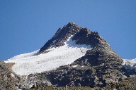
 From the north
 From the southwest
The Fletschhorn, lacking only 7 meters from being a 4000m peak, is the northernmost summit of the Weissmies group that includes Lagginhorn and Weissmies and is considered to be one of the most complex peaks in the area. The NW ridge is the normal route from the Weissmieshütte. However, routes of all difficulties exist on all sides of the mountain. Its imposing north face and east side ridges provide some of the most demanding routes in the Alps and thus the Fletschhorn has sometimes been called the most beautiful Swiss 3000m-peak .
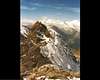
 From the west
The Fletschhorn was first climbed by Amherdt, Zumkenni and Klausen on 28 Aug 1918. The first winter ascent was completed Jan 1, 1914 by A & R Calegari and G Scotti. Von Martin and Supersaxo first climbed the Fletschhorn on skis March 22, 1918. See the Routes Overview for history of each route.
Getting There
 From the northeast
Depending on which route you are doing, the mountain is approached either from the Saas Valley via Brig and Saas Grund to the west or the Simplon pass area to the east, via Brig or Domodosola.

Use Mapquest or refer to any highway map for specific driving details.
Brig can be reached by train from either Geneva and up the Rhone Valley, from Zurich-Bern-Spiez-Kandersteg, from Furka-Oberalppass (Andermatt/Disentis, Glacierexpress) or from Domodosola, Italy.
Saas Grund - Weissmies
Transfer to a bus in Brig to reach Saas Grund (Saas Fee). Although the train goes to Visp and Zermatt, you must get the bus in Brig to reach the Saas Valley.
To come by car, one travels via highway towards or through Brig. You turn south in Visp, which lies west of Brig, as if driving to Zermatt. In Stalden, turn SE towards Saas Grund.
Reach the Weissmieshütte on foot from Saas Grund in 3 hours or in 1 hour from the station Kreuzboden of the cable car Hohsaas. From the summit station of the cable car Hohsaas, one can descend 380 meters on a good to trail to reach the hut in 30 min.
Simplon/Egga, Laggin/Fletschhorn Bivouacs
Simplon Pass lies east of Brig along the highway between Brig and Domodosola. From there the approaches are either from Simplon Village or Egge, which lies between the pass and Simplon village.
To reach the Laggin Biwak one hikes from Simplon Village - Weng - Antonius - Färicha to reach the shelter in about 3 hours.
To reach the Fletschhorn Biwak , you first go to Rossboden, a 1.5 hours hike from Egga, which lies between Simplon pass and Simplon village. However, you can drive to Rossboden by private car or possibly arrange a taxi. From the Rossboden you hike north over grass to Pt. 2020, then over the Griessernen moraines to the Griessernen glacier and finally south from the glacier to the shelter in about 4 hours.
Routes from the West (Weissmieshut)
This is a general summary of the various routes. Consult a guidebook and the routes added by SummitPost members for specifc details.1. W-flank and topmost NW-ridge (normal route)
WS to PD, depending on which guidebook you consult, 4 to 5 hours from the Weissmies hut, 1280 vertical meters. First climbed by James and Supersaxo in 1889. This is a snow/glacier climb with some rock scrambling along the way. Also used in descent, if not making a traverse of the mountain. Otherwise one can descend the east ridge to the Fletschhornjoch and either descend to the Weissmies hut or continue on to Lagginhorn.
2. SW-Ridge (Topham)
PD with pitches of UIAA II, 5.5 hours from the Weissmies hut. More direct than the normal route by takes longer to complete. The lower section has become increasingly loose and tricky because of glacier recession. First ascent by Topham, Rendall and Supersaxo in 1887.
 |  |  |
Routes from the East (Laggin & Fletschhorn Bivouacs)
This is a general summary of the various routes. Consult a guidebook and the routes added by SummitPost members for specifc details.3. SE- Ridge (Hohsaasgrat)
Of the 3 ridges which extend down the eastern side of the mountain, this is the steepest and most difficult. AD with short pitches of UIAA II/III, about 5 hours from Laggin bivouac, which is at its base. Entirely a rock climb until one reaches the summit ridge. First ascent by Gardiner, Cox Knubel, Dorsaz, 5 July 1876.
4. E-Ridge (Zibelengfluhgrat or Sibilufluegrat)
PD, 5 hours from the Laggin Bivouac. Rarely done. First ascent by GF & GB Gugliermina, Schiavi and Caron, 20 July, 1900
5. NE-ridge (Breitlaubgrat or Breitloibgrat)
PD-, pleasant mixed climbing on easy but loose rock, 4 h from the Fletschhorn bivouac hut or 9 hours from Egga. Often used in descent.
6. N-face (Rossboden Face)
The north face was climbed for the first time by E. R. Blanchet with the guides Oskar Supersaxo and Kaspar Mooser on the 25th of July 1927. They needed 6 hours for the approach from Simplon village and 5,5 h for the face. A second ascent took place not until 1948. On the 17. July 1960, seven members of the Austrian Alpine Club opened a new route under guidance of Erich Vanis: the Wienerroute. So within 33 years, the face was climbed only 3 times. According to Vanis, there was no fourth climb until 1978. Vanis had problems when he climbed the face. They had to make steps. This is a pure ice tour to the topmost NW-ridge, 50° and more at the end, 600 vertical meters, S+, 4 h (only the face). It is usual to start from the new Fletschhorn Biwak which lies in a small saddle at 3014m elevation on the ridge between the Griessernen and Rossboden glaciers.
 |  |  |  |  |
Accommodations
There are numerous camping sites hotels, pensions and condos available in the villages on both sides of the range. It is a popular area so reservations are advised.The Weissmies Hut is the hut from which to base the west side routes.
On the east side, some of the routes can be done in a very long day from Simplon Village or Egga. There is a private hut The Simplon Hospiz directly on the pass. There are two formal bases: the Laggin Biwak which has room for 10 with no services and the new (1999) Fletschhorn Biwak with room for 9.
 |  |
General Information and Resources
GENERAL INFORMATION:WEATHER- avalanche
- MeteoSuisse
- Extreme Weather
- Saas Grund - Kreuzboden cable car live web cam
- Saas Fee web cam
- 1:25000 no. 1309 Simplon
- 1:50000 no. 5006 Matterhorn-Mischabel
mgillie - Dec 13, 2006 9:48 am - Hasn't voted
Topham RidgeContrary to the comment on the page this ridge seems to be completed fairly commonly according to the hut book. I climbed it in 2005 and found the line a little loose and vague lower down but very pleasant higher up. The higher section consists of climbing over a serious of notches in a narrow ridge on solid rock
Fred Spicker - Dec 13, 2006 2:00 pm - Voted 10/10
Re: Topham RidgeChange made - thank you for pointing this out.
Mauntainfreak - Jan 7, 2016 4:28 pm - Hasn't voted
Photo taken from JegihornThis photo was taken from the Jegihorn which was climbed by the via ferrata. (click it to enlarge):