
|
|
Mountain/Rock |
|---|---|
|
|
46.37333°N / 9.88278°E |
|
|
12916 ft / 3937 m |
|
|
Introduction
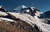
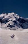
Piz Roseg is a big firn pyramide on a black rock massif. The great northface stands out with its heavy ice balconies and hanging glaciers. The Piz Roseg has 3 summits, the main summit with 3937m, the secondary summit with 3920m called Schnekuppe situated north completely in Switzerland and Roseg Pitschen 3868 m on the border and ridge leading to the neighbouring Pit Scerrscen. The Schneekuppe is probably the most popular summit. You have the best view to the magnificent northface from the Piz Scerscen which is located just on the opposite side of the Piz Roseg.>Especially, if there are a lot of climbers in this route, you have a lot of waiting time in the rock passages to admire the great iceface. The impressive effect of this face is reinforced by the big notch between the Porta da Roseg, which separates this western foremassif from the mainmassif of the Bernina. It seems incredible to find a way through the enormous hanging glaciers to the summit of the Piz Roseg. But this route has already been climbed more than 100 years ago. On the 16. July 1890, Christian Klucker, the most important pioneer of the Bündener Alps, has climbed the NE-face of the Piz Roseg together with Ludwig Norman-Neruda, only a few days after their common victory over the Northface of the Lyskamm. The second climbing of this NE-face of the Piz Roseg has been undertaken not until 1925 by Hans Fritz von Tscharner and his companions, 35 years after the first climb of the northface. In the upper part of the face, they climbed more through the left side then the first climbers. In 1958, Kurt Diemberger and Karl Schönthaler opened the direct route through the northface. They have passed the icebreaks in the left lower part of the face and met the Tscharner-route in the middle of the face. Just because of its extreme difficulties, it is climbed more and more today. The development of "ski extreme", which began during the time between the both world wars, has reached the Piz Roseg as well. This terrifying northface was downhilled by ski by Kurt Jeschke and Martin Burtscher on 4. June 1978. It is extremly dangerous. Heini Holzer, a very successful skimountainer concerning steep faces, had been fallen to death here in the Roseg-NE-face one year ago. The slightest mistake in this face is probably the last one.< (Paragraph translated from Vanis: "Im steilen Eis", courtesy Rahel Liu)
 |  |  |  |  |
Routes Overview
The Piz Roseg is most frequently climbed from the Tschierva-hut:1. NW-ridge :
In 2 hours from the hut to the saddle (3148 m) south of Piz Aguagliouls, called Fuorcla dals Aguagliouls. One more hour on a tiny path sometimes on the sourth side to the main junction 3598 where 3 climbs from different sides meet. Climb with crampons to the Schneekuppe (3920 m). From there reach the saddle to the main summit on your left, now stay on the ridge to get to the top. 6 hours from the Tschierva hut. Difficult.
2. N-ridge :
From the Tschiervahut follow the path to Prievlus, cross the Tschierva glacier at ca. 2700 m, climb to the foot of the Umur ridge, then head for the N-ridge called La Crasta. An old Wallis guide thought it looked like the 4-Eselsgrat on the Dent Blanche and some people call it tody Eselssgrat. But this ridge seems to me much shorter than the one in Wallis. After this ridge head for the junction at 3598 m and follow the NW-rige. The first ascent did Mr. Middlemore etc. Difficult. 7 hours.
3. NE-face:
Many different routes: Klucker (to the saddle between Schneekuppe and main summit), Tscharner and Diemberger-Schönthaler to the summit, Huss-Müller-Gut and Haider-Schmid to the Schneekuppe.
This wall cannot be climbed in warm weather or when the wall shines blue with ice. Very difficult. 5-10 hours.
4. ENE-ridge :
From the saddle west of Piz Scerscen (3522 m) to the Roseg Pitschen on bad rock (IV) in 6 hours to the main summit. I cannot tell you much about climbing the saddle (Portra del Roseg) because I gave up when I stood below the blue, icy saddle, the awful schrund and the stones falling down.
Starting from the Coaz hut.
5. NW-ridge :
Mainly with skis! From the Coaz follow the route to the Fuorcla de la Sella. Climb as high as possible towards pt. 3598 before you leave the skis there. Then follow route 1. Difficult. Only for very experienced skiers and winter climbers. 7-8 hours.
6. SW-ridge (Sella ridge) :
Reach the Fuorcla de la Sella - between Piz Roseg and Piz Sella. From the Coaz hut via pt. 2587m . 5 hours.
From the Rifugio Marinelli via Passo Marinelli in 2-3 hours. Much shorter from Biv. Parravicini.
From the Sella saddle stay always on the ridge to the top. Good rock, very long. IV. 7 hours from the saddle.
7.SSE-ridge :
From Biv. Parravicini or Rifugio di Marinelli reach pt. 3099. This is ca. 150m to the left of the starting point to Roseg Pitschen (3868 m). Rock. Safe. IV.
There are more ascents like the Marinelli couloir which are not recommended due to falling rocks. Yes, it was the famous Damian Marinelli who died in "his"couloir on the Dufourspitze on August 13th, 1881. A month earlier - July 14 - he successfully climbed Piz Roseg and opened another dangerous route.
 |  |  |  |  |
When To Climb
The North Face routes may be climbed through the entire year. Access may be more easy or safe using skis and leaving them at the base of the climb. Beware of avalanche danger though.(MichaelBoos)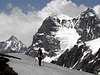 |  |
General Information
For books, maps, webcams, trains, buses, weather, avalanches, rescue see my list Swiss Links in a new window.See the Swisstopo Map with many interesting features. Upload is in a seperate window.
Accommodation
The Chamanna da Tschierva (2583 m) is the most used hut for Piz Roseg. But there are others, that can be suited for a climb:Chamanna Coaz (2610 m)
Bivuaco Parravicini (3183 m), 1 km south of Piz Roseg, 6 beds
Rifugio Marco e Rosa (3597 m)
Rifugio Marinelli (2813 m)
1. Tschierva hut, 2573 m
100 beds
3 hours walk from Pontresina or by mountainbike or coach (reservation by phone necessary!) to the Hotel Roseggletscher (1999 m) in the Roseg valley. 1 hour less from the hotel. Wonderful scenery, easy to find.
Pontresina (hotel, camping, car, train) is located next to St. Moritz.
2. Coaz hut, 2610 m
80 beds
From Pontresina - Hotel Roseggletscher in 3.5 hours
In winter also from cable car station Corvatsch with downhill to Fuorcla Surlej - Vallun dal Murtel (2569 m). 2.5 hours.
3. Rifugio Marinelli-Bombardieri, 2813 m
176 beds, located 4.5 km south of Piz Bernina.
From the Campo Moro Dam (1990m) in 3 hours. The hut is open in April/may and from July to September and is located in Val Malenco (Italy) 33 km above Sondrio in the Valtellino valley.
4. Rifugio Maco e Rosa, 3609 m
48 beds, located 1 km south of Piz Bernina. 8 hours from the dam.
From the Marinelli-Bomardieri hut in 3 hours, last part on a via ferrata. The hut is open from July to September and is located in Val Malenco (Italy) 33 km above Sondrio in the Valtellino valley.
Guide Books and Maps
Books: (German or French):
Clubführer Bündner Alpen Vol. 5: Bernina Gruppe, Verlag Swiss Alpine Club
Alpine Skitouren, Vol. 2: Graubünden. Verlag Schweizer Alpen-club
Maps:
1:25000 no. 1277 Piz Bernina
(1:25000 no. 1257 St. Moritz)
1:50000 no. 268 Julierpaß
ISBN 3-405-12158-2
ISBN: 3763324178
Ari - Feb 22, 2010 3:54 am - Hasn't voted
SSE RidgeIf SSE Ridge means "SE Flank via Piz Roseg Pitschen" (SSE Ridge, SSOGrat auf dem Piz Roseg Pitschen, route 407.2 in SAC Clubführer) I have to disagree with it being safe. The quality of rock is very bad, therefore there's significant rock fall danger. Once you are on the route, retreat is virtually impossible due to lack of good anchors and very high probability of ropes getting stuck and/or dislodging rocks when rappelling.