

-
 23221 Hits
-
 90.99% Score
-
 34 Votes
|
|
Mountain/Rock |
|---|---|
|
|
46.12602°N / 7.74584°E |
|
|
Mountaineering, Mixed, Scrambling, Skiing |
|
|
Spring, Summer, Fall, Winter |
|
|
12576 ft / 3833 m |
|
|
Overview
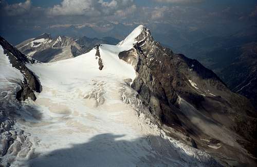
Brunegghorn as seen from the Weisshorn east ridge
What a nice mistake that was. I viewed "only" Brunegghorn and its neighboring summits. Compared to the Walliser Weisshorn, Bishorn and the Mischabel peaks, with a height of 3833 m Brunegghorn is only second row. These summits were in dense clouds these days and I took Brunegghorn as one of the famous 4000 m peaks.
But this mistake only emphasizes what an impressive mountain Brunegghorn nonetheless is. Showing very high and steep faces especially down to the Matter valley, Brunegghorn stands about 2400 m high above the villages of Herbriggen and Randa. To the north, northwest and southwest this keen mountain rises out of the Abberg, Brunegg and Bis glaciers, three rather impressive ones with many seracs, crevasses and bergschrunds.
Brunegghorn is one of the peaks on the long and huge Weisshorn ridge which starts in the south near Dent Blanche, and includes famous summits like Zinalrothorn, Weisshorn and Bishorn. The whole ridge ends much further north at Dreizehntenhorn in the Augstbordhorn region and splits up in two subridges high above Rhone valley. It separates the Turtmann valley to the west from Matter valley to the east.
Brunegghorn is located northeast of Weisshorn, east of Bishorn and south of Schöllihorn. Bisjoch (3540m) and Schöllijoch (3365m) are the saddles that separate our summit from their eponymous neighbors. The Bisjoch is the key saddle, giving Brunegghorn a prominence of 293 m.
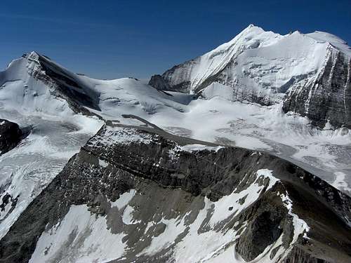
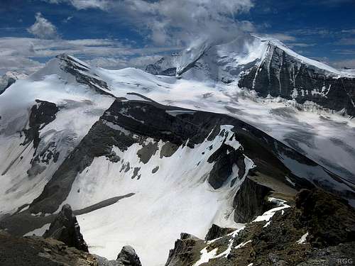
Brunegghorn, Weisshorn and Bishorn as seen from Barrhörner
Google terrain view centered on Brunegghorn.
Zoom in for a closer view, or Click here for a larger map
Zoom in for a closer view, or Click here for a larger map
As Brunegghorn is below the "magic line" of 4000 m, this summit is not too crowded. It is an excellent outing to get accustomed to the height and offers marvelous views to Walliser Weisshorn, the Mischabel group and the Zermatt mountains.
A great traverse, partly a ski route too, is:
1. day: Sankt Niklaus – Topali hut
2. day: Topali hut – Brunegghorn – Turtmann hut
3. day: Turtmann hut – Les Diablons – Cabane de Tracuit
4. day: Cabane de Tracuit – Bishorn - Zinal
Brunegghorn was first summited in 1853 by J. and F. Tantignoni with their Swiss guide H. Brantschen.
Getting there
Trailheads for Brunegghorn are: Brunegghorn as seen from Mattertal (om) |  Turtmann lakes as seen from Holustei |  Brunegghorn as seen from Mattertal |
The green paddle points at Brunegghorn.
Zoom in for a closer view, or click here to view a larger map
Zoom in for a closer view, or click here to view a larger map
At Visp follow the signposts to Stalden. At the round point crossing take the first exit in the direction of Sankt Niklaus and Zermatt.
Take the first road to the right after entering Sankt Niklaus and proceed to the huge parking garage near the railway station. The ascent to Topalihut starts at the railway station.
Another trailhead is further on: leave the road to Zermatt before it crosses the Mattervispa creek (at Hotel La Reserve) to the right and go to Birchmatte, Stalu and Ze Schwidernu, where another trail starts to Topali hut.
 Turtmann hut |  Signposts at Topali hut |  Topalihut common room |
Alternatively go on from Sankt Niklaus to Herbriggen. Parking at Herbriggen is very much restricted!
Junggu can be best reached from Sankt Niklaus railway station via the cablecar
You reach Sankt Niklaus and Herbriggen with the swiss railroad, too. Check the railway schedule here.
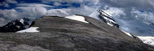
Panorama with Schöllihorn and Brunegghorn
Vorder Sänntum / Turtmann valley by car
The approach is nearly the same as to Sankt Niklaus. Instead of heading to Visp on road number 9 go to Turtmann, a small village some km west of Visp. Take there the small road to Oberems and go on into Turtmann valley until its end after the small village of Gruben / Meiden at Vorder Sänntum. There are free parking areas at the roads end.
There is a swiss postbus connection from Turtmann railway station to Gruben. Check the railway schedule here.
Routes Overview
Approach to Turtmann hut Turtmann lakes and hut |  Turtmann hut ascent |  Brunegghorn southeast face (om) |
Other routes to Turtmann hut
Approach to Topalihut
From Sankt Niklaus / railway station (or Ze Schwidernu) to Sattel – Medji – Bode – Walkerschmatt to the hut.
 Ascent to Topali hut |  View to Barrhorn from Topali hut |  Ascent to Topali hut |
Other routes to Topalihut
Routes to Brunegghorn
- Normal routes from Turtmann hut; rated PD-
via Gässi – Brunegg glacier – Bruneggjoch – southwest ridge col – southwest ridge or
via Gässi – Schöllijoch – Schöllihorn – Bruneggjoch – southwest ridge col – southwest ridge
Both normal routes are described more precisely here. - Normal route from Topalihut; rated PD-
via Chella cirque – point 3020 m – rests of Schölli glacier – secured route to Schöllijoch – Schöllihorn – Bruneggjoch – southwest ridge col – southwest ridge.
The direct route from the Topali hut – Chella - Bruneggjoch via the Abberg glacier is, due to glacier retreat, becoming more and more difficult (huge crevasse zone). Check the situation at Topali hut! - Northwest ridge; rated AD-
UIAA grade II, mixed rock, snow and ice, interesting route.
The ridge starts at tje Bruneggjoch which can be reached as described in 1. and 2. The first rock part of the ridge is easy. It becomes more steeper when the snow ridge starts which is interrupted by three rock steps; these require rock climbing up to grade II.
Best to be done early in the year as the snow tends nowadays to melt completely away in late summer. - Northeast ridge; rated AD+
Interesting ice route and short snow ridge. A bit of scrambling in the uppermost parts of the ridge.
For the northeast ridge route walk from Turtmann hut to Bruneggjoch (see 1.) and descend shortly to the uppermost part of Abberg glacier.
From Topalihut follow route number 2. to Abberg glacier and ascend the glacier in the direction of Bruneggjoch.
Turn there in east / southeastern direction and ascend the Abberg glacier to the northeast ridge. You reach the ridge at about 3600 m height. Follow the ridge to the summit. - North face route (57 degrees; rated D)
First ascent:
Emilie R. Blanchet, Kaspar Mooser, 14. August 1925
It is a rather short but steep ice face. Due to climate change it is best to be done until early summer. Later in the year the snow / ice will partly be gone and rock fall will get more and more serious.
As described in route 4. walk up to the uppermost part of Abberg glacier. Cross the bergschrund at a height of about 3600 m directly below or a bit left of the summit rocks. Asend the ice face by aiming a bit left in the direction of the northeast ridge. Due to the snow and ice conditions you tackle the uppermost steep part directly or you bail out onto the northeast ridge. - Ski route
The ski route in late winter and spring follows mainly the lower part of the route 1. It then enters Brunegg glacier and follows the glacier up to the southwest ridge.
 Schöllihorn route |  View down from high on Bishorn, with the NW ridge, W face and SW ridge (cyrill) |  southwest ridge (cyrill) |
 View from Topali hut |  Abberg glacier |  Start of the secured route to Schöllijoch |
 N face and NW ridge from Barrhorn |  N face and NW ridge seem from Schöllihorn (cyrill) |
 northeast ridge and north face (om) | 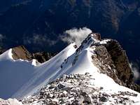 northeast ridge (ninjapilot) |  east face, northeast ridge and north face (om) |
 north face from Topali hut |

Red Tape & Accommodation
Panorama as seen from Barrhorn
Red Tape
No restrictions as far as I know.
Matter valley parking areas are always a bit pricy!
Accommodation
Sankt Niklaus
Herbriggen
Gruben / Turtmanntal
Mountain huts
Turtmannhütte; lovely homepage!
Topalihütte
Gear & Mountain Condition
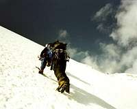
Brunegghorn is a year round outing and an interesting one! Use Brunegghorn for an acclimatisation tour and combine a ridge route as ascent with one of the normal routes for descending.The normal routes are easy glacier routes, but let there be no mistake: all Brunegghorn glaciers can have nasty crevasses and bergschrunds!
The ridge routes and the north face route are mixed rock and ice routes and therefor only for the experienced mountaineer.
The summer normal routes require full glacier gear.
The northeast and northwest ridges are mixed terrain: a rope, some ice screws, carabiners, quicks and long extender for a belay will do no harm.
The north face route requires a 50 m rope, some ice screws, good ice tools, a helmet and full glacier gear.
Late winter and spring Brunegghorn is a well known ski tour, often combined with a traverse from Turtmann hut to Cabane de Tracuit and to Bishorn.
In winter you need full ski tour, glacier and avalanche equipment.
Check the swiss avalanche bulletin here.
Current Weather:
Maps & Guide Books
MapsUnfortunately Brunegghorn and its ascent routes are spread over several of the 1:25 000 Swiss topo maps:
1307, Vissoie
1308, St. Niklaus
1328, Randa
A good alternative is the 1:50 000 Swiss topo map
5028T, Monte Rosa Matterhorn
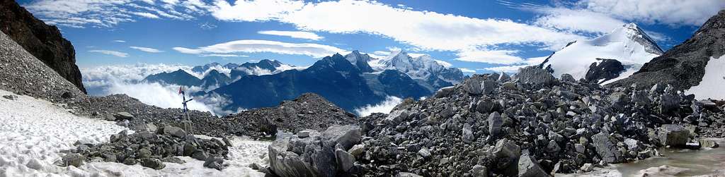
Panorama with Brunegghorn from along the route from the Topalihütte to the Schöllijoch
Guide Books
Banzhaf, Biner, Theler: SAC - Clubführer Walliser Alpen, Matterhorn, Dent Blanche, Weisshorn, vom Col Collon zum Theodulpass, SAC-Verlag, 2010
Marianne Bauer, Michael Waeber: Gebietsführer Walliser Alpen, Bergverlag Rudolf Rother, München, 14. edition, 2012
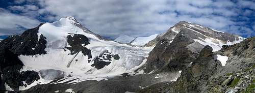
Panorama as seen from Schölli glacier, with the beautiful white Brunegghorn north face on the right