
|
|
Mountain/Rock |
|---|---|
|
|
42.67554°N / 0.03428°E |
|
|
Hiking, Mountaineering, Trad Climbing |
|
|
Spring, Summer, Fall |
|
|
11007 ft / 3355 m |
|
|
Overview
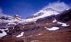
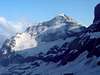
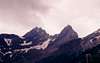
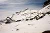
The third highest mountain in the Pyrenees, ranking only below Pico de Aneto and Posets, it was described by the frenchman Louis Ramond de Carbonnières as "the most beautiful limestone peak in Europe". Monte Perdido stands as the highest summit in the Massif of the 3 Sorores (the other two being Cilindro de Marboré and Soum de Ramond) and offers an easy way to cross over the barrier of three thousand meters for the first time. The date of the first succesful climbing is still not clear, though the first documented one is that of the french guides Laurens and Rondo in 1802 (6th August), paid by Louis Ramond de Carbonnières and accompanied by an unknown local shepherd. The spanish topographer Vicente Heredia might have summited about ten years before, though, according to some french documents of the end of the 18th century. The easiest route is a quite steep walk-up in the summer, going over a scree corridor in the north side of the peak. In winter time, though, it becomes a snow and ice climb and calls for the use of piolet and crampons. Impressive sights from the summit if you are lucky enough to climb it in a clear day.
 |
 |
 |
 |
 |
A word about the name
"Monte Perdido" is the spanish translation of the french "Mont Perdu", in english "Lost Mountain". For the spaniards living in nearby valleys this name had no logics, nor meaning. It was not a lost mountain for them, as it could be seen (in clear weather) from places as far away as Zaragoza. They knew the whole massif (Monte Perdido, Soum de Ramond and Cilindro de Marboré) as "Tres Sorores" (that is: three sisters) or "Treserols". Meanwhile, french people knew it as "Mont Perdu" because of its obvious tendency to disappear (hidden by the Cilindro de Marboré and Pic de Marboré) as one travelled south and approached the border through the Gave de Gavarnie.
Getting There
Monte Perdido is placed in the spanish National Park of Ordesa and Monte Perdido, with two main accesses. The best option is to drive until you get to the village of Torla or the valley of Pineta (about 13 km west from Bielsa).
Out of the high season, you can drive into the National Park from Torla. In summer and Easter Holidays you have to leave the car at the big parking in the entrance of Torla. Public buses start from that point and take you to the Park, right at the point to start walking (la pradera de Ordesa).
There is also an old path leading from Torla into the National Park, which begins at the lower part of the village. It takes an additional 2 hours to reach la pradera this way.
NEAREST MAJOR AIRPORTS: Zaragoza / Barcelona (323 km).
ROAD ACCESS: From Zaragoza to Huesca, excellent highway. After that you have two main possibilitiesa) Road number N-330 to Sabiñánigo, across the tunnels of Monrepos. After Sabiñánigo you have to get road N260 north for 13 km and turn right at Biescas following the road C-138 (road signs "Ordesa"). Then you cross the Col of Cotefablo and after 24 km turn left at the crossroads marked Torla. From that point on it's only 2 km to the parking lot or 8 km to the pradera de Ordesa.
During the summer season and some additional holidays (such as Easter week, check dates), access of private vehicles to the Ordesa Canyon is forbidden. In such a case, you must leave your car at Torla and take one of the buses serving the traject to the old parking of La Pradera. Either that, or walk along the old path (Camino Viejo) for a couple of hours.

Torla
b) If you want to enter the Park by Pineta (eastern access), turn right at Huesca and follow road signs to Barbastro (road N-240). After this town, follow road number N-123 (direction Graus) and turn left on road n. C-138 to El Grado and Aínsa. When you reach this last village do not leave that road, follow north the signs to Bielsa or Francia. After 33 km, in Bielsa you can find the crossroads to turn left and reach the Parador Nacional de Pineta (National Hotel) in 13 more km.
BUS ACCESS: The bus company "La Oscense" serves the village of Torla starting from Sabiñánigo or from Aínsa. More details available at http://www.alosa.es. Phone contacts are 974355060 (in Jaca) and 974480045 (in Sabiñánigo).
Another possibility is Hudebus, a company serving the line from Sabiñánigo to Aínsa and back (including stops at Torla and Broto, the villages placed closest to the Park). Phone number 974213277 (in Huesca)
RAILWAY ACCESS: The nearest rail stations are the ones at Sabiñánigo and Barbastro. This means that a minimum of forty kilometers will stand between you and the National Park from any of them. Additional transport will therefore be required (see "Bus access").
 |
 |
 |
 |
Red Tape
No need for permits or summit fees. The only money to be payed is the fare of Torla parking lot and the public bus (if necessary). Both used to be quite reasonable last time I visited the place.
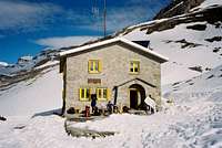
IMPORTANT: Monte Perdido is a quite long climb. Most people allow for a night at the Góriz Mountain Hut, but the place is not too big and reservations are highly recommended. Moreover, the hut belongs to a nearby Council and some problems have arisen lately about the issue of keeping it open or not. Remember: the whole climb crosses a National Park. That means extreme care and respect for the fabulous wildlife of Ordesa Canyon.
The National Park Regulations, as apported to this page by Diego Sahagún are the following:
PRUG (Real Decreto 409/1995):
- Free camping is forbidden. It's permited to vivy or camp using a tent lower than 1.3 m/ 4 ft 3.25 in, wich would be taken down at dawn. This practice is allowed above these heights:
Ordesa area: 2.100 m (Clavijas de Soaso)
Añisclo area: 1.800 m (Fuen Blanca)
Escuaín area: 1.800 m (La Ralla)
Pineta area: 2.500 m (Balcón de Pineta / Bolán de Marmorés)
- Sports aside hiking, climbing, ski-mountaineering and speleology are forbidden.
- The sale of commercial products is not allowed
- It's forbidden to swim in the rivers, streams and lakes
When To Climb
The right moment to climb Monte Perdido depends on your readiness to accept some risks. If you are an expert mountaineer and familiar with winter conditions, winter time can be nice in spite of the short days but winter climbing should be restricted to the normal route. Be specially careful in the upper section of the Normal Route Corridor, it is particularly steep and almost every winter some climber gets killed there.
If you don't want to run into any special problems, summer is the best possible time for this summit. Long days with lots of sun and clear sights from the top.
 |
Miscellaneous Info
For weather information, one of the most reliable sources that I know of is the French Institute of Meteorology (http://www.meteo.fr). You can also trust the Spanish Institute (http://www.inm.es) and http://www.barrabes.com/eltiempo/meteo.asp (this is a private web page of a mountaineering shop in Benasque, Spain. It offers good weather information).
External Links
- Ordesa
The most complete page about the National Park, including information on lodging and almost any kind of activity you can undertake over there. - Refugio de Góriz
Web page of the Góriz Mountain Hut. English, french and spanish language versions available. - Tozal del Mallo
Summitpost page about another climb in the National Park of Ordesa and Monte Perdido. Fine information on how to get there and lodging facilities - Mountain and Climbing Guiding/Instruction
Rock and Ice climbing School and Mountain Guiding.
desainme - Oct 11, 2005 7:20 am - Hasn't voted
Untitled CommentI proposed corrected coordinates for Mont Perdu and the Cylinder in Site Feedback, Fix these coordinates section. I got them from Google Earth.
eza - Oct 11, 2005 9:22 am - Hasn't voted
Untitled CommentThanks, rbi. At a first glance my coordinates were giving a west longitude, and it had to be an east one. That is already corrected. I am also looking at data kindly given by desainme
eza - Oct 11, 2005 9:31 am - Hasn't voted
Untitled CommentHi, desainme. Thanks for your effort. I have already corrected the coordinates according to what you wrote in "site feedback" but I am not feeling easy about them... If you don't mind to check the map, you will see that the new position is set a little bit too far away northwest. Somewhere around the summit of Marboré. The real summit (Ordesa Canyon is a good reference in the interactive map) should be southeast of this one. Not too far away, but southeast. I shall be looking for new data on my own but am still open to any suggestions. Thanks again and all the best
Diego Sahagún - Jul 24, 2003 4:39 am - Voted 10/10
Untitled CommentThe PRUG (Real Decreto 409/1995) says:
Free camping is forbidden. It's permited to vivy or camp using a tent lower than 1.3 m/ 4 ft 3.25 in, wich would be taken down at dawn. This practice is allowed above these heights:
Ordesa area: 2.100 m (Clavijas de Soaso)
Añisclo area: 1.800 m (Fuen Blanca)
Escuaín area: 1.800 m (La Ralla)
Pineta area: 2.500 m (Balcón de Pineta / Bolán de Marmorés)
Sports aside hiking, climbing, ski-mountaineering and speleology are forbidden.
The sale of commercial products is not allowed
It's forbidden to swim in the rivers, streams and lakes
Rick B - Oct 10, 2005 10:08 pm - Voted 10/10
Untitled CommentHey eza,
It seems that the coordinates you have for Perdido are wrong, as are a lot of other Pyrenees mountains. Check out the interactive map, find Gavarnie (which seems to be located correctly given the geography). Perdido should be right next to it, just as Taillon, Astazu .. etc..
They're all too far south + Taillon is east of Perdido, which is obviously wrong as well..
Cheers,
Rick
desainme - Oct 11, 2005 7:20 am - Hasn't voted
Untitled CommentI proposed corrected coordinates for Mont Perdu and the Cylinder in Site Feedback, Fix these coordinates section. I got them from Google Earth.
eza - Oct 11, 2005 9:22 am - Hasn't voted
Untitled CommentThanks, rbi. At a first glance my coordinates were giving a west longitude, and it had to be an east one. That is already corrected. I am also looking at data kindly given by desainme
eza - Oct 11, 2005 9:31 am - Hasn't voted
Untitled CommentHi, desainme. Thanks for your effort. I have already corrected the coordinates according to what you wrote in "site feedback" but I am not feeling easy about them... If you don't mind to check the map, you will see that the new position is set a little bit too far away northwest. Somewhere around the summit of Marboré. The real summit (Ordesa Canyon is a good reference in the interactive map) should be southeast of this one. Not too far away, but southeast. I shall be looking for new data on my own but am still open to any suggestions. Thanks again and all the best
Diego Sahagún - Jun 24, 2009 6:29 am - Voted 10/10
Nuevas Webs y una preguntaEnrique, adjunto la dirección del Refugio de Góriz de la FAM, la que pones en tu página no funciona (al menos a a mi): http://www.fam.es/comites/refugios/refugiogoriz.htm Esta es más directa: http://www.goriz.es/ Tampoco el enlace de Sendas funciona ahora. En el Spanish Team del Message Board he dejado una pregunta, a ver si tu o Rafa estáis informados, o cualquier otro. Gracias
eza - Jun 29, 2009 10:03 am - Hasn't voted
Re: Nuevas Webs y una preguntaGracias por la información, Diego, ya está corregido.