
|
|
Mountain/Rock |
|---|---|
|
|
47.73778°N / 121.00992°W |
|
|
Chelan |
|
|
Hiking, Mountaineering, Scrambling, Skiing |
|
|
Spring, Summer, Fall |
|
|
6765 ft / 2062 m |
|
|
Overview
Jim Hill Mountain is a peak located approximately 3.7 miles east of Stevens Pass in Washington. The mountain is perhaps most well-known and visited by skiers but is perhaps most notable for local peakbaggers. The mountain is one of Washington's peaks with at least 2000' of prominence. In addition, the nearest higher peaks are approximately four miles away to the east and south, with no peaks nearby that are higher to the west and north, making for potentially fantastic views during the upper summit approach and from the summit ridge. Jim Hill Mountain
Although the standard summit approaches are considered non-technical, the summit ridge itself is not. This is one of those "pick your poison" mountains. During Spring and perhaps even early Summer, snow on the lower sections of the approaches will help cover annoying and troublesome brush, but snow on the summit ridge will make that section a potentially dangerous mixture of steep and loose rocks, snow, and knife-edge ridges. During Summer through late Autumn, the lack of snow on the approaches will uncover vast and bothersome brushy sections, but the summit ridge itself will be no more difficult than Class 3 rock scrambling.
 Dangerous Summit Ridge (Spring: Snow, Wet Rocks)
 Class 3 Scramble On Summit Ridge (Summer: No Snow)
Jim Hill Mountain was named in honor of James ("Jim") Hill, a famous 19th Century railroad tycoon whose Great Northern Railway was the first non-indigenous travel route to go through Stevens Pass. The Great Northern Railway was also the first intercontinental railroad to be built without public funding. These were perhaps two of the biggest reasons that Jim Hill became both a local and national hero, worthy of a peak being named in his honor.
Getting There
Some locals have an old saying for the approaches of Jim Hill Mountain:"You gotta go through Jim Hell to get to Jim Hill."
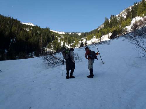
There are four main approaches for Jim Hill Mountain: the Henry Creek approach (from the northeast), the Lanham Lake "North Spur" approach (from the northwest, the Whitepine Creek approach (from the south), and the Arrowhead Mountain approach (from the east). Each approach has its advantages and disadvantages, especially depending upon the season.
HENRY CREEK (NORTHEAST) APPROACH:
 General Route Map For Henry Creek Approach
This is perhaps the second-most used approach route for Jim Hill Mountain, but possibly also one of the safest routes.
1) Take U.S. Highway 2 eastbound from Stevens Pass.
2) Drive approximately 6 miles to where the divided highway ends.
3) Shortly after the divided highway ends, there is a small unmarked gravel road (Forest Road 680) on the north side of the highway. Turn onto the road and park alongside it, off from the highway, and walk eastbound 0.2 miles down the side of Highway 2 until reaching an old forest road (Forest Road 678) on the south side of the highway. Or, if no snowpack is alongside the highway, park inside that road entrance. Do not block the entrance/access gate of Forest Road 678.
Do not park alongside Highway 2 and do not park in the large pullout near the eastern portal BNSF Railway Tunnel.
HIKING DIRECTIONS:
1) From the gate on Forest Road 678, briefly walk before leaving the road and heading uphill through thick evergreen forests.
NOTE: If you follow the road until reaching Henry Creek, you have walked too far.
2) Continually head south and uphill, and by 3600' elevation you should be side-traversing gradually uphill through thick forests.
NOTE: During periods of no snowpack, there is some brush in this lower forested section but nothing to prevent progress.
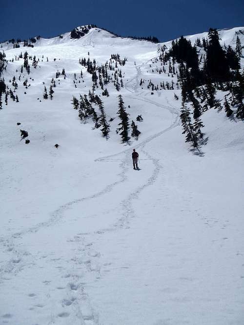
 Angling South Through Thick Evergreen Forests...
3) At approximately 3900' elevation, the lower forested section ends at a large semi-open basin containing slide alder. The false summit hill of Jim Hill Mountain starts to be seen in the background.
NOTE: During periods of snowpack, the slide alder is mostly (if not entirely) snow-covered and the gully is just an open slope. During periods of no snowpack, the slide alder is present and can slow progress.
 Entering Slide Alder Basin...
4) A waterfall is approached at approximately 4300' elevation. Side-traverse on the right (north) side of the waterfall until above and beyond it.
5) Continue heading uphill, soon reaching a small evergreen forest.
6) A very large open upper gully is reached at approximately 4900' elevation. Continue ascending gradual slopes of the upper gully towards the false summit hill, aiming for a saddle to the right side of the false summit (on the north ridge of Jim Hill Mountain).
NOTE: DO NOT attempt to go to the left side of the false summit hill, due to rockfall and rock climbing conditions and concerns. During periods of snowpack, it is best recommended to follow a line of trees up the western side (climbers' right) of the upper gully to avoid as much avalanche danger as possible in that section.
 Looking At Large Upper Northeast Gully
7) Reach a small saddle at approximately 6200'-6300' elevation. From this saddle, the true summit hill can now be seen to the southwest.
8) Cross over the north ridgeline saddle and gradually ascend up to the saddle (some call it a "notch") located between the false summit hill (climbers' left) and larger true summit hill (climbers' right).
 False Summit (Left), Saddle/Notch (Center), True Summit (Right)
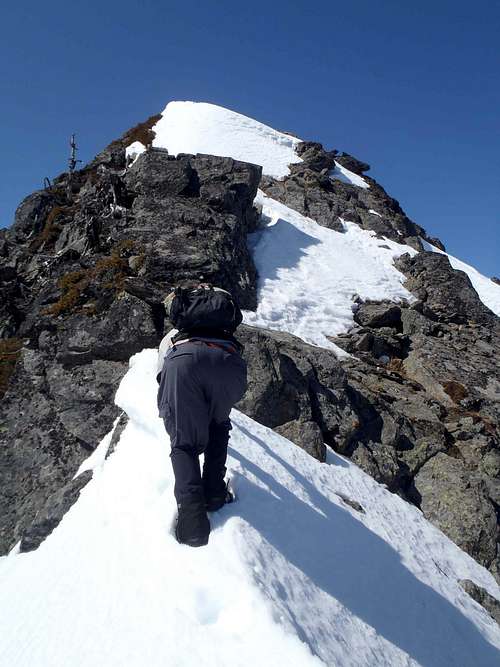
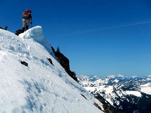
9) Once at the summit ridge saddle/notch (6650'), turn west and begin scrambling up the rocky summit ridge.
10) After the initial steep and exposed scramble section, the summit ridge gradually gets better. A rock spire is passed halfway between the summit ridge saddle/notch and the true summit. The summit ridge is combination of Class 2 terrain and occasional brief Class 3 moves. The final slope to the true summit is nothing more than a regular hike.
NOTE: Beware of loose rocks and steep drop-offs along the summit ridge and scramble sections.
 Steep Summit Ridge Mixed With Snow...
 Atop The True Summit
------------
LANHAM LAKE ("NORTH SPUR") APPROACH:
This is probably the most used and shortest approach route for Jim Hill Mountain, but also known as a route with a lot of avalanche potential, routefinding issues, and brush problems.
The approach via Lanham Lake is described on the "North Spur" route page.
 Approaching Upper Saddle/Notch Via "North Spur" Route
------------
WHITEPINE CREEK (SOUTH) APPROACH:
In the past, this was a longer but far less technical summit route option. The route follows the Whitepine Creek Trail #1582 eastward from Josephine Lake (or westward from Forest Road 6950 near White Pine Campground). The route used to follow hiking trails until approximately due south of the Jim Hill Mountain summit, and then a steep but direct uphill ascent to the summit. The off-trail ascent was no worse than Class 2, and if on-route was generally considered a steep walk-up.
Unfortunately, when last checked, Whitepine Creek Trail #1582 had not been a maintained trail for many years and was greatly overgrown. Some reports have even claimed Whitepine Creek Trail is indistinguishable/unusable at multiple sections. Due to the poor conditions of the Whitepine Creek Trail, this route might be best recommended while a little snowpack still exists on the mountain slopes but when no avalanche danger is present (due to the very steep south-facing slopes of Jim Hill Mountain), such as during early Summer. However, if the Whitepine Creek Trail is overgrown and not snow-covered, then that would definitely slow down hiking progress and would defeat the purpose of using the route with those conditions.
For those thrill-seekers out there hoping to explore this route option, or if Whitepine Creek Trail #1582 gets re-established and cleaned-up in the future, here are the hiking directions:
FROM STEVENS PASS (4056' elevation):
1) Hike south along the Pacific Crest Trail (PCT) for 4.5 miles until reaching the Icicle Creek Trail #1551/Josephine Lake turnoff (4950' elevation).
2) Hike along Icicle Creek Trail #1551 for 1.1 miles until reaching the Whitepine Creek Trail #1582 turnoff (4400' elevation).
3) Head east along Whitepine Creek Trail #1582, heading uphill for the first 0.4 miles to a small saddle and then down along the Whitepine Creek drainage for another 3.1 miles until generally due south of the true summit of Jim Hill Mountain.
4) Leave the trail. Hike steeply uphill to the summit of Jim Hill Mountain.
FROM THE END OF FOREST ROAD 6950 (2800' elevation):
1) Assuming Forest Road 6950 can be driven to its original road-end at 2800' elevation, hike west/southwest along the Whitepine Creek Trail #1582 for 5.0 miles until generally due south of the true summit of Jim Hill Mountain.
2) Leave the trail. Hike steeply uphill to the summit of Jim Hill Mountain.
------------
ARROWHEAD MOUNTAIN (EAST) APPROACH:
This route option looks good on paper, but is less desirable and much more technical in reality. Arrowhead Mountain is considered a non-technical summit destination, and is located at the far eastern end of the Jim Hill Mountain ridgeline, several miles away. The route is basically a ridge traverse from Arrowhead Mountain to Jim Hill Mountain. This route has been attempted by multiple mountaineers and thrill-seekers, most of whom flat-out fail or decide to turn around due to its sometimes difficult rocky terrain.
1) Follow the standard approaches for the summit of Arrowhead Mountain.
2) Head southwest, generally following the ridgeline but not always on the ridgetop. There are at least eight different rocky points that are passed along the ridgetop between Arrowhead Mountain and Jim Hill Mountain.
NOTE: Most of the rocky points on the ridgetop will need to be traversed around rather than directly over due to sometimes difficult, steep, and/or loose rocks. This route option should never be attempted during periods of snowpack.
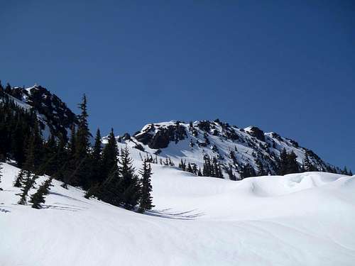
 Looking Towards Jim Hill Mountain From Arrowhead Mountain
Red Tape
No parking passes or permits are required for the Henry Creek approach.A Northwest Forest Pass (parking pass) is required for the Lanham Lake approach.
Jim Hill Mountain (and its ridgeline) is located along the northern boundary of the Alpine Lakes Wilderness. The north side of the mountain is not located within the wilderness area, but the south side is.
When To Climb
For summit attempts, Jim Hill Mountain is best recommended from late May through late November.From December through May, the peak is almost exclusively visited by backcountry skiers. With that said, very few people attempt to summit the mountain during those months due to avalanche-prone slopes and unstable summit ridge conditions. Most Winter and Spring visitors to the mountain are just skiers hoping to take advantage of the vast open upper north slopes that are great for skiing.
Camping
No official campgrounds are located in the area. During Summer and Autumn, backcountry camping is allowed.Mountain Conditions
Check the Stevens Pass Ski Area Web site for current conditions.Also consult the Avalanche Report for the area prior to heading out.