
|
|
Mountain/Rock |
|---|---|
|
|
37.82176°N / 107.79396°W |
|
|
Mountaineering |
|
|
Summer |
|
|
13309 ft / 4057 m |
|
|
Overview
 West Face of V2 from US Grant Peak
 Summit
Many climbers know this peak as V2.
If you are looking for a front row seat in the parade of jagged peaks, you must get yourself to the top of this mountain where you will have spectacular views of the following peaks: Fuller Peak (13761 ft), Vermilion Peak (13894 ft), Golden Horn (13765 ft), Pilot Knob (13738 ft), U.S. Grant Peak (13767 ft), South Lookout Peak (13357 ft) and many others.
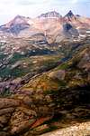
Peak 13309 rises above Clear Lake, a perfect fisherman's hideaway in the San Juan Mountains of southwestern Colorado. The lake sits at an elevation of 11940 ft and is accessed via a rough and sometimes scary 4 wheel drive road. To the north and west, the lake is bound by the steep slopes of South Lookout Peak. To the south, the scree slopes of Peak 13309 drop steeply into the lake. The north slopes of Peak 13309 can be described as 1100 ft of steep scree leading to 300 ft of cliffs on the summit.
Without giving any details, "Climbing Colorado's San Juan Mountains" by Robert F. Rosebrough describes the hike from Clear Lake as "easy and pleasant". These are of course relative terms that depend on one's level of experience and state of mind. I would characterize the hike from Clear Lake as an arduous and frustrating struggle against a seemingly endless scree slope. The view from the top, however, is worth the struggle.
An approach from the south via Island Lake is also possible and is said to be more pleasant. (see Route).
 |  |  |  |  |
 Southwest face, from Island Lake
Getting There & Route via Clear Lake
From Silverton drive 2 miles north on Route 550 till you see the sign for South Mineral Campground Road (on the west side of Route 550). This is a well-graded dirt road that is passable by any car. Follow this road for 3.8 miles until the junction of the 4 wheel drive road to Clear Lake on the right (before you reach the campground). In only 4 miles, Clear Lake Road goes from an elevation of 9800 ft to the east end of the lake at 11940 ft (Jeep rental available in Silverton).Starting Point Elevation: 11940 ft (Clear Lake)
Oneway Distance (per my GPS): 0.80 miles, all slippery scree, allow 2 hours uphill
Maps: US Geological Survey, Colorado (Ophir grid)
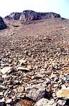
To avoid the cliffs on the top of Peak 13309, you must hike to near a saddle above the southwest end of the lake. To reach there, you can choose to hike the north or the south shore of the lake. At first glance, the north shore, which is covered with grass, seems more promising, however, once you reach the west end of the lake, you will run into a series of cliffs and steep slopes. You can probably avoid these if you plan your route carefully (I did not want to risk it and chose to hike the south shore).
The south shore is covered with loose scree that makes the hike very slow and unpleasant. Hike parallel to the surface of the lake 100-200 ft above it. Don't gain too much elevation or you will run into cliffs. Once you near the saddle, the slopes ease up a little and the rocks become larger making it less slippery. Look to the top to locate a scree slope that cuts through the cliffs on the summit. Follow this slope to the summit. Expect nasty scree again all the way to the top.
 |
Red Tape
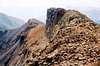
 V2 & US Grant
 V2 on left
No permits or fees required for day hikes.
 |  |  |  |  |
When To Climb
Easiest in summer.Click to see the forecast for Silverton, CO.
 View from the summit of V2, Island Lake seen