
|
|
Mountain/Rock |
|---|---|
|
|
44.35960°N / 15.50220°E |
|
|
Hiking, Mountaineering, Skiing |
|
|
Spring, Summer, Fall, Winter |
|
|
5764 ft / 1757 m |
|
|
Google Earth
Since Google has blessed us with its magical Google Earth software you can visit any corner of the world from the chair parked in front of your computer. Thankfully Velebit is amazingly clear so you can discover its corners and see for yourself how it looks from the above and where are the places this page is dedicated to.Each geographical point of interest described on this page has coordinates on the top of its section. You can use these coordinates with Google Earth’s fly to search engine. Just copy the coordinates (like it is written, with coma) and paste them into fly to tab and press enter. And, of course, enjoy the flight!
Overview of Vaganski Vrh – Sveto Brdo group
 Segestin (1715m), Malovan (1709m), Sveto Brdo (1751m) and Brundo (1714m) from the slopes of Vaganski Vrh (1757m)
In 10km long stretch Velebit massif, which length of 145km makes longest in Dinaric Alps chain, reaches its culmination. All of 10 main peaks of Velebit that exceed 1700m are placed here, inside Vaganski Vrh – Sveto Brdo group. It all takes part on South Velebit. Group was simply named after two highest peaks of Velebit: Vaganski Vrh (1757m) and Sveto Brdo (1751m).
Borders of the group, which is very compact, are well defined. Of 4 sides of the world it faces only NW side isn’t very steep and doesn’t fall deep. It rises above Struge (1400m), high undulating grassy plateau, while on the SE is similar Dusice (1300m) plateau. Seaboard or SW side falls steeply towards upper Velika & Mala Paklenica and Orljaca valleys, whose bottoms are 1000-1200m lower. Upper third is made of cliffs and scree while lower two thirds are under forest. Cliffs of some peaks occupy two thirds of the slope falling deep towards Paklenica. Continental or NE side is similar, even steeper. With few hundred meters high cliffs it falls towards narrow continental terrace which is on altitude between 1100 and 1300m. Terrace contains beautiful grassy basins/meadows which are squeezed between highest peaks and forested peaks of continental step. Those are: Stirovac (1300m), Smrcevac (1200m), Vagan (1150m), Medacki Dolac (1330m), Bunovac (1185m) and Dolina Cubrilova (1320m). View from their meadows toward peaks above is one of most beautiful on the whole mountain. Whole group also acts like torn main crest of Velebit.
Now when borders are defined lets move onto peaks. On this area which is 10km long and few kilometers wide many peaks are scattered but some order can be found. Most peaks are lined up in continental or seaboard streak of peaks. Distance between them is biggest on the NW end above Struge. From there streaks get closer all the time till they melt into one in Bili Vrh (1657m), 7km SE of Struge plateau. This page is dedicated to this part of the group. On this stretch between peaks are huge funnel shaped basins, some are over 100m deep. Largest is one between Babin Vrh and Vaganski Vrh, then one between Vaganski Vrh and Brundo and Janjcara between Malovan and Liburnija. Peaks in continental streak are much more defined than those in seaboard. Between them are deep passes and such basins while peaks in the seaboard streak are connected with high and sharp ridge. From the NW lined up in the continental streak are: Stirovac (1569m), Babin Vrh (1738m) (has 3 heads above 1700m), Vaganski vrh (1757m) (highest peak of Velebit), Golic (1723m), Segestin (1715m) and Malovan (1709m). From the NW in the seaboard streak are: Rapavac (1617m) (described on Paklenica page), Crljeni Kuk (1661m) (described on Paklenica page), Zoranicev Vrh (1712m) (between both streaks, behind Crljeni Kuk), point 1660m, Brundo (1714m) (little bit inside, between both streaks), Liburnija (1710m), point 1707m, point 1670m, point 1654m and Bili Vrh (1657m). While peaks fall with cliffs and scree towards both sides, among them story is quite different. This area, which consists of huge funnel shaped basins and sharp connecting ridges, is predominantly grassy, as are slopes of continental streak above them, with scattered bushes of dwarf pine. Rock and some smaller cliffs can also be found, especially among seaboard streak peaks. Their northern sides which fall into basins are usually under dense colonies of dwarf pine which makes them almost impassable.
SE of Bili Vrh (1657m) and Bunovacka Vrata (1620m) pass stretches last third of the group. It changes face here as seaboard streak disappears and is just a terrace below what is now main crest. Below terrace is steep forested slope which falls into Mala Paklenica or Orljaca valleys while above it is soft grassy slopes. On the edge of the terrace there are few small peaks which exceed 1500m. Main peaks are: Solilo (1675m), point 1689m, Babin Vrh (1744m) (third highest on Velebit), point 1725m, point 1710m and finally Sveto Brdo (1751m) (second highest peak of Velebit), on the SE end of the group. Continental terrace exists till below Babin Vrh where is grassy basin Dolina Cubrilova (1320m). Behind it terrace melts into the continental side and Sveto Brdo falls uninterrupted all the way to Lika region.
Vaganski Vrh – Sveto Brdo group is placed inside Paklenica NP which has been established in 1949 and is second oldest Croatian National Park. Area of highest peaks and Paklenica area below them, together with Zavizan area &
Rozanski Kukovi group, are arguably most beautiful parts of Velebit.
 Winter in Vaganski Vrh – Sveto Brdo group
Highest peaks of Velebit, above 1700m:
1) Vaganski Vrh (1757m), described on this page
2) Sveto Brdo (1751m)
3) Babin Vrh (1744m), described on Sveto Brdo page
4) Babin Vrh (1738m), described on this page, contains two more heads: points 1725m and 1723m
5) Golic (1723m), described on this page
6) point 1720m, between Babin Vrh (1744m) and Sveto Brdo (1751m)
7) Segestin (1715m), described on this page
8) Brundo (1714m), described on this page
9) Zoranicev Vrh (1712m), described on this page
10) Liburnija (1710m)
11) point 1710m, between Babin Vrh (1744m) and Sveto Brdo (1751m)
12) point 1710m, in front of Babin Vrh (1744m)
13) Malovan (1709m), described on this page
14) point 1707m, near Liburnija (1710m)
 Continental side of Velebit, Vaganski Vrh group, from Lika region
--------------------------------------------------------------------------------------------------------------------
 |  |  |  |  |
Vaganski Vrh (1757m)
44°21'58.33"N, 15°30'13.53"E On the summit of Vaganski Vrh (1757m)
Vaganski Vrh is highest peak of Velebit. It is large peak with broad summit which has 4 smaller heads of similar height. Vaganski Vrh is mostly grassy with some rock and colonies of dwarf pine, from all but N side which faces Lika region behind Velebit. Towards it, or to be more precise, towards continental terrace, Vaganski Vrh falls with few hundred meters high cliffs. On the NW is impressive amphitheater which it forms together with the cliffs of the ridge which extended towards Babin Vrh (1738m). Below the cliffs are large scree slopes and boulder basin. Similar amphitheater, but smaller, is also on the E side which it forms with SE neighbor Golic (1723m). Towards Babin Vrh, behind edge of the cliffs (NW), is huge funnel shaped basin, which is around 150m deep. Behind the edge towards Golic (E) is also funnel shaped basin, but shallower and small than one towards Babin Vrh. On the S is yet another funnel shaped basin, also very big, which separates Vaganski Vrh from Brundo (1714m). Highest part of Vaganski Vrh is in line with continental streak. But apart from its neighbors which are placed completely inside the streak Vaganski Vrh acts like a bride between both streaks and is perpendicular on them. Southern ridge gradually descends till the edge of seaboard ridge. Because of this Vaganski Vrh is the only unavoidable peak when on the trail from Struge towards Sveto Brdo (1751m) or vice versa.
Vaganski Vrh can be approached from all but continental direction. It is possible to do it via 5 different trails from Paklenica hut, in Velika Paklenica, which is main trailhead. It is crossed by VPP trail on the way from Struge towards Sveto Brdo. Easiest approach leads over Buljma pass (1400m), via Struge refuge (1400m) and VPP trail (Velebit long distance trail). Lipa Staza route is most direct but very steep and tough. Bukova Staza route is also steep but more comfortable than Lipa Staza. It joins VPP and Struge refuge route below Babin Vrh (1738m), between Struge and Vaganski Vrh, 1h from the summit. Most attractive and panoramic but steepest and most difficult is Lipa Staza route, branch via Liburnija (1710m). It joins VPP SE of Vaganski Vrh, 40mins from the summit. None of these approaches lasts less than 5h from the Paklenica hut. 5th Paklenica hut approach is more an option than regular route. It leads via Ivine Vodice refuge and lasts 7h. Vaganski Vrh can also be accessed from other parts of Velebit like from Visocica (1619m) via old VPP variation. On Struge it joins current VPP. It is possible to do it from Rujno via VPP too. This route also joins Struge refuge route. When visiting this part of Velebit it is best to combine Vaganski Vrh with Sveto Brdo (1751m), second highest peak of Velebit. More about that is in Hike Advices section.
 |  |  |  |  |
Summit View
 Night view from Vaganski Vrh (1757m) towards east
View from the summit of Vaganski Vrh is beautiful and wide, in one word fantastic. Towards sea it is not as good as from the undisputed Panorama King of Velebit, Sveto Brdo (1751m), but in some other aspects even better. Vaganski Vrh probably has most beautiful continental view on whole Velebit. It falls steeply towards continental terrace of South Velebit with few hundred meters high cliffs. View towards sea is little bit obscured by seaboard streak of peaks which is above Paklenica valley but it is wide enough to be considered very nice anyway.
NW: this is probably most exciting part of panorama. Just bellow Vaganski Vrh is huge cauldron closed from 3 sides by steep cliffs. Its bottom, which is few hundred meters bellow, is strewn with huge boulders. In the background is massive triple headed Babin Vrh (1738m) which occupies much of panorama in this direction. In front of it is huge funnel shaped basin. Behind Babin Vrh is rest of Velebit, seen all the way to its beginning on the NW. Visible in between is grassy cone of Visocica (1619m), just left of Babin Vrh, and Satorina (1624m), highest peak of Mid Velebit. Above Babin Vrh, further towards right, Rozanski Kukovi & Zavizan groups are visible.
N: below the large amphitheater of cliffs is nice rounded Vagan (1150m) meadow, placed on the continental terrace below highest peaks of Velebit. Above and behind Vagan is forested Lisac (1484m), which melts with surrounding forest of continental side of Velebit. Behind Velebit is huge flat Licko Polje karst field (average altitude is around 550m), largest in Croatian part of Dinaric Alps. It is part of even wider Lika region behind which, in the distance, is Kapela mountain. Lika region is split in two parts by Licko Sredogorje massif which is around 1200m high.
NE: Lika dominates this section of panorama also but closing it now on the opposite side is Licka Pljesivica mountain with Gola Pljesivica (1648m) peak while further towards right is Ozeblin (1657m), highest peak of Licka Pljesivica. Between Velebit and Licka Pljesivica is Licko Sredogorje massif.
E: behind Lika and Licko Sredogorje massif is still Licka Pljesivica mountain with Kremen (1591m) peak. Just right of Kremen is Osjecenica (1798m) mountain and Klekovaca (1961m) mountain, further right, both are in Bosnia.
SE: is dominated as NE by close Velebit peaks, all of which belong to Vaganski Vrh – Sveto Brdo group. First neighbor of Vaganski Vrh is Golic (1723m). Right of it, with sharp summit ridge, is Segestin (1715m). Further right is massive cone of Malovan (1709m). Just above Malovan is another Babin Vrh (1744m) while right of it is Sveto Brdo (1751m). Now we’ll return little bit because of more distant panorama. Between Golic and Segestin, in the distance, are Postak (1446m), long Ilica (1654m) and Sator (1872m) mountain in Bosnia. Between Segestin and Babin Vrh is Crnopac (1404m), highest peak of SE Velebit. Just above it, but far behind, is Dinara (1830m), highest Croatian mountain. Right of Dinara is Troglav (1913m), highest peak of Dinara mountain which belongs to Bosnia.
S: more peaks of Velebit, close to Vaganski Vrh. Just in front is Brundo (1714m) while right of it is Liburnija (1710m). Above and far behind is North Dalmatian plateau with Svilaja (1506m) & Promina (1148m) mountains. Right of Liburnija is Ravni Kotari county and islands of Sibenik archipelagos behind it.
SW: below Velebit is Velebit channel with flat Ravni Kotari county behind. Further away is sea and islands of Zadar archipelagos. On super clear day Italy is also visible in this direction, led by Corno Grande (2912m), highest peak of Apennines.
W: behind western shoulder of Vaganski Vrh is Crljeni Kuk (1661m) and Zoranicev Vrh (1712m). Right of it is Viserujna (1632m). Behind these peaks is sea with numerous islands.
 |  |  |  |  |
Struge
Buljma Pass 44°22'7.10"N, 15°27'52.87"EStruge plateau (lower, central) 44°22'22.72"N, 15°27'59.95"E
Struge refuge 44°22'35.43"N, 15°28'2.91"E
Struge plateau (upper) 44°22'44.54"N, 15°28'22.39"E
Marasovac well (upper Struge) 44°22'43.96"N, 15°28'32.58"E
 Struge and Badanj (1638m)
Struge is large undulating grassy/rocky plateau placed between seaboard and continental streak of peaks. Word strugati means to scrape. Surface of Struge looks just like it was scraped by glacier. Maybe it was since it is confirmed that through nearby Ribnicka Vrata pass glacier was descending towards Rujno plateau. Average height of Struge is around 1400m. Avaricious grass grows between small, milled, rocks on the scraped surface of former summer pastures today. Area is surrounded by idyllic, highest layer, of beech forest and nice peaks which gives very romantic impression. Struge is divided in two parts: lower and upper. Lower Struge is much larger with dimensions of 2km in W-E direction and 1km in N-S direction. On the W is Viserujna (1632m), on S Buljma pass (1400m) and on the E forested slopes of Rapavac (1617m). On the N is undulating forested area which divides it from more distant Javornik (1300m) field and close upper Struge. Upper Struge is divided from lower by narrow passage that consists of meadows and beech groves. Unlike wide undulating area of lower Struge upper is one larger funnel shaped basin which has diameter of almost 1km. Bottom is on 1370m while edges reach 1450m. On the N is Badanj (1638m), NE Stirovac (1569m) and on the E Babin Vrh (1738m). On the NE edge of upper Struge is well known Marasovac well which always has water. In late autumn, winter till late springs don’t count on it as it is under deep snow. Because of possible mines left from early 90’s war it is not advisable to go from Marasovac further towards continental side of Velebit and Lika region.
In the area of beech groves and meadows, which separates lower from upper Struge, Struge refuge (1400m) is placed. More about the refuge is in Objects section. Struge is meeting point of paths from 3 main directions. 45mins below Buljma pass VPP trail from Rujno direction is joined by path from Paklenica hut. They jointly cross over the pass on Struge. Old VPP variation from Visocica (1619m) via Oglavinovac and Javornik high field approaches Struge from NW. From Struge VPP continues towards Vaganski Vrh – Sveto Brdo group. 4th direction would be from Medak village in Lika, behind Velebit, but because of possible land mines it is not advisable to use it although if one wants to test luck it’s free to use it.
 |  |  |
Stirovac (1569m)
44°22'57.25"N, 15°28'56.48"E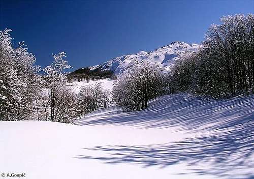 Stirovac (1569m) from Struge
Stirovac (read Shtirovac) is first peak in the continental streak of Vaganski Vrh – Sveto Brdo group, which contains highest peaks of Velebit. It is placed on its NW end, above upper Struge plateau and Corina Prosina meadows in the continental terrace of South Velebit. Stirovac is double headed peak. Northern peak (1569m) is higher while southern, closer to Struge, is little bit lower. Stirovac is rocky peaky with some larger smooth rocky plates and layers of rock. It rises above predominantly beech forests which are mixed with some spruce and fir. Southern slopes above Struge are bare rocky with lot of dwarf pine. On the NW, across the undulating forested area on the continental edge of Velebit, is Badanj (1638m). Its closest neighbor is massive Babin Vrh (1738m), on SE.
Stirovac is pathless peak without marks. It is very rarely ascended as its neighbors draw more attention. Easiest approach leads from Marasovac well over open rocky terrain, straight towards the peak which is just above (around 30mins). From it is another 20mins to the north summit.
 |  |
Babin Vrh (1738m)
44°22'36.08"N, 15°29'19.50"E Babin Vrh (1738m) and Babino Jezero (1598m) lake
Babin Vrh is first peak above 1700m in the continental streak of Vaganski Vrh – Sveto Brdo group. It is placed on the NW edge of the group, above Struge plateau, some 1.6km from Vaganski Vrh. Babin Vrh is massive triple headed peak. Highest and largest is main peak in the middle, (1738m). Few hundred meters towards north is continental summit (1725m). Between them is shallow saddle. SW of main summit is SW peak (1723m). Between it and main peak is deeper saddle. From all but northern side slopes of Babin Vrh are mostly rocky with some grass and dwarf pine, especially NW side. SW side is completely rocky and looks like scree slope. At its foot lies Babino Jezero (1580m) lake. Towards north continental peak fall falls steeply with few hundred meters high cliffs towards continental terrace which is almost 600m lower. On the terrace lies beautiful rounded meadow Vagan (1150m). Closest neighbor of Babin Vrh is Stirovac (1569m) on the NW. On the SW is Vaganski Vrh (1757m). Between them is huge funnel shaped basin, around 150m deep. North of basin is sharp ridge, which with few hundred meters high cliffs falls towards continental terrace. On the south is Zoranicev Vrh (1712m) while on the SW is nameless peak 1655m.
Babin Vrh is beautiful viewpoint, especially continental peak from which is fantastic view on cliffs above continental terrace. Babin Vrh isn’t marked but access over open slopes is easy. VPP trail (Struge route section) traverses its southern slopes on the way from Struge refuge towards Vaganski Vrh (1757m). When coming from this direction Babin Vrh is closest from the pass between it and nameless peak (1655m), which is on the top of ascent from Struge plateau. Bukova Staza route, which leads from Paklenica hut, meets VPP on the other pass, between Babin Vrh and Zoranicev Vrh, some 15mins above Babino Jezero Lake. From both passes it takes some 15-20mins to the summit. Babin Vrh is rarely someone’s lone goal. Also it is rarely ascended by hikers on the way towards Vaganski Vrh or from it as most don’t have a will to tackle another peak along the way. As a lone goal Babin Vrh is tough as any Velebit peak. Shortest approach from the coast via Velika Paklenica and Bukova Staza route lasts almost 7h!
If you have time and will it is interesting to use sharp continental ridge on the way between Vaganski Vrh and Sveto Brdo. It is more interesting than marked path which traverses slopes SW of huge funnel shaped basin. It is especially beautiful in winter but extra care is needed because drifts made by south or west winds are overhanging above the cliffs.
 |  |  |  |  |
Babino Jezero lake (1580m) & Babin Dolac valley (1450m)
Babino Jezero Lake 44°22'19.80"N, 15°29'10.52"EBabin Dolac Valley 44°22'10.09"N, 15°28'51.35"E
 Babino Jezero in late spring
At the foot of bare rocky SW slope of Babin Vrh, on the bottom of shallow funnel shaped depression, lies Babino Jezero (1580m) lake. Its dimensions are 20x40m and is 7m deep. Its origins are glacial. Lake has nice blue color but bottom is muddy. In the water, around the shore, grows Mrijesnjak (Potamogeton Natans). Area around the lake is predominantly rocky with some avaricious grass and dwarf pine bushes scattered around. It looks like it has been scraped by glacier. Lake is fed by precipitation but never dries, nor does its level vary much. In summer brave ones can swim in it. During long period of the year Babino Jezero is frozen or under snow, from November till June. After first snow falls it becomes invisible and remains like that till June. View from the lake is dominated by the dome of Babin Vrh (1738m). On the south is Zoranicev Vrh (1712m), on NW nameless peak 1655m.
 Babin Dolac
Towards SW basin with Babino Jezero is open and over small pass it descends to one floor lower Babin Dolac (1450m). It is beautiful short grassy valley placed between by beech forested slopes at the back of Rapavac (1617m), on the west, and Zoranicev Vrh (1712m) on the east. Lower slopes of Zoranicev Vrh are under highest layer of beech which soon disappears before dwarf pine and grass. On the south Babin Dolac is closed by pass between Rapavac (1617m) and Crljeni Kuk (1661m). In the middle of the pass is nice cliff. Behind the edge of the pass slope descends steeply towards upper Velika Paklenica valley, which is 1000m lower. In summer and autumn grass at the bottom of Babin Dolac reaches above ones waist.
Through Babin Dolac and by Babino Jezero lake Bukova Staza route ascends from Paklenica hut towards VPP and Vaganski Vrh (1757m).
 |  |  |  |  |
Zoranicev Vrh (1712m)
44°22'3.50"N, 15°29'13.48"EZoranicev vrh is bridge peak between Crljeni Kuk (1661m) (described on Paklenica page) in the seaboard streak (S) and Babin Vrh (1738m) in the continental streak of peaks (N). From Crljeni Kuk it is divided by shallow saddle while towards Babin Vrh it is bit deeper pass (both around 1650m). Between the summit and pass towards Babin Vrh is another head, little bit below 1700m. On the west is Babin Dolac (1450m) valley while on the east are grassy slopes and funnel shaped depressions towards Vaganski Vrh (1757m). Nice pyramid of Zoranicev Vrh is grassy with some layers of rock and inevitable dwarf pine.
It was named Zoranicev Vrh after a famous Croatian poet Petar Zoranic who wrote about Velebit more than 500 years ago and is one of first writers in the world who has been inspired by mountains and wrote about them. Conclusion was reached between the mountaineering clubs from Dalmatian and Lika regions. On May 20th 1973 plate was placed on the summit. Zoranicev Vrh used to be marked but marks faded and are hardly visible lately. Approach led from Babino Jezero (1580m) Lake. Since this is open terrain no marks are necessary to reach the summit. It is best to combine Zoranicev Vrh with Crljeni Kuk, from which is fantastic view down into Velika Paklenica valley and further towards sea. Even more interesting is ascent from the pass of Bukova Staza route which is bit closer. Behind the cliffs of Crljeni Kuk head towards the grassy saddle between its summit and Zoranicev Vrh. From Paklenica hut it takes some 4.30h. For those who seek adventure in wild terrain ascent through Ravne Drage gorge and over Ploce (smooth plate cliffs at angle) east of Crljeni Kuk is very beautiful. This is only for experienced mountaineers.
 |  |
Golic (1723m)
44°22'0.96"N, 15°30'42.45"EGolic is nice rounded cone placed in the continental streak of Vaganski Vrh – Sveto Brdo group. From its closest neighbor, Vaganski Vrh (1757m), which is on the west, it is separated by large rounded funnel shaped depression (bottom 1590m). Few hundred meters high continental cliffs of both peaks form impressive couloir on the north. SE neighbor of Golic is sharp Segestin (1715m). On the south is Brundo (1714m). From it is separated by one of smaller funnel shaped depressions which form one huge basin between Vaganski Vrh, Golic, Segestin and Brundo. Whole basin is overgrown by dense dwarf pine which makes it impassable. Golic is grassy on all but northern side. On grass there is lot of scattered dwarf pine.
As continental summit of Babin Vrh Golic is pushed little bit outside of line that other peaks in continental streak form. Because of that it provides beautiful view upon the northern cliffs of the surrounding peaks. Yet, Golic is unvisited peak as nearby highest peak of Velebit, Vaganski Vrh, draws all attention. Those that reach Vaganski Vrh are mostly either tired or have long way still ahead to even consider ascending nearby Golic. Easiest and most logical approach leads from Vaganski Vrh via ridge above continental cliffs.
 |  |
Brundo (1714m)
44°21'31.70"N, 15°30'45.65"ENicely shaped cone of Brundo is real dwarf pine fortress which makes it difficult to access. It belongs to seaboard streak of highest peaks but it is not in first line above Velika Paklenica as in front of it, towards SW is bit lower head (slightly above 1700m). On the NW, across large basin (bottom 1490m) which is under dense dwarf pine carpet, is Vaganski Vrh (1757m). On the NE is Segestin (1715m). They are separated by pass (around 1600m) over which VPP trail crosses. On the south is Liburnija (1710m) from which it is separated by another funnel shaped basin, overgrown by dwarf pine.
Brundo is not very interesting view point. On any other mountain it would be great but here on Velebit where it is surrounded by numerous better views points it is second league. Sea view is partially obscured by bit lower head in front and by Liburnija while towards Lika Golic, Segestin and Malovan reduce the view significantly. Nearby Liburnija (1710m) has amazing sea view while towards Lika Vaganski Vrh is unmatched. Brundo is approache by marked paths from two directions. One leads from VPP which branches on the pass between it and Segestin. Path has been cut through dense dwarf pine. From VPP it takes around 20mins to reach summit. Other approach leads from Liburnija. This path goes around few funnel shaped basin and through dwarf pine before joining variation from VPP, 5-10mins below the summit. It is best to visit Brundo in winter when dwarf pine is under deep snow and one can walk around anywhere it wants.
 |
Segestin (1715m)
44°21'46.08"N, 15°31'5.22"E Segestin (1715m) from Bunovac (1200m)
Segestin has two faces. From western and northern direction it is sharp, beautifully shaped pyramid while from southern direction it is bulky peak with wide summit ridge. It is because its razor sharp summit is stretched in W-E direction. Segestin is placed in the streak of continental peaks. From all but northern side, where it falls with few hundred meters high cliffs towards continental terrace, Segestin is grassy, with scattered dwarf pine. Close neighbor on the NW is Golic (1723m) from which it is separated by a pass (around 1630m). On the SW is Brundo (1714m). Together they close NW part of large basin that stretches till the foot of Malovan (1709m), SE neighbor of Segestin. Pass (1500m) over which basin breaks towards continental terrace separates extended SE ridge of Segestin from Malovan. This ridge contains two quite sharp heads which reach little bit above 1600m. Deep in the northern foothill, on the continental terrace, is nice meadow Medacki Dolac (1330m). It is surrounded by deep beech forests.
Segestin is also one of rarely or better to say unvisited peaks among highest on Velebit. Reasons are same as are for Golic. Most hikers that pass just below it on the way from or towards Vaganski Vrh don’t even consider adding yet another peak to their collection. Most are pleased to have Vaganski Vrh as it is not easy to get here. Easiest and shortest approach leads from pass between it and Brudno which is crossed by VPP trail (Vaganski Vrh – Sveto Brdo section). Ascent leads over grassy slopes, between dwarf pine bushes. It lasts some 20-30mins.
 |  |
Malovan (1709m)
44°21'20.73"N, 15°31'38.11"E Malovan (1709m) from Liburnija (1710m)
Malovan is one of most beautiful peaks of Velebit. Its almost perfectly shaped cone is placed in the continental streak of highest peaks of Velebit. Southern half of the cone is grassy, with scattered dwarf pine bushes, while northern half is made of torn cliffs which are few hundred meters high and fall towards continental terrace. On the W is large basin which it surrounds together with Brundo (1714m) (W) and Segestin (1715m) (NW). On the bottom of the basin (1460m) are rocky walls and hardly recognizable ruins of Zapadni Malovanski Stanovi or western Malovan shepherds houses. People used to live here during summer with their cattle till this semi nomadic way of life died some 50 years ago. Slopes of Malovan above it are under dense carpet of dwarf pine. On the S is large Janjcara basin (bottom 1510m) which stands between Malovan and seaboard ridge that doesn’t have eminent peak here. On the spot where ridge which separates Janjcara from basin that contains Zapadni Malovanski Stanovi touches slopes of Malovan (SW foot) is small terrace with basin which waters of Malovansko Jezero (1600m) Lake used to fill. During last 10 years it is dry. Why water retreated is not known. On the SE side of Malovan cone is similar, bit larger terrace, where are also hardly recognizable ruins of Istocni Malovanski Stanovi or eastern Malovan shepherds houses. Altitude of 1600m made them highest on Velebit. They were used by shepherds from the villages near small town of Obrovac. On the terrace is also larger periodical pond which was used as watering place for cattle. Deep in the NE foothill, placed on the continental terrace, is 2km long grassy valley of Bunovac (1200m).
Southern slopes of Malovan are traversed by VPP trail. Shortest approach leads from former Malovansko Jezero Lake or Istocni Malovanski Stanovi. It lasts 15-20mins. View from the summit is beautiful towards Lika region behind Velebit and especially towards Bunovac which is almost perpendicularly below. View towards sea is obscured by seaboard ridge. Malovan is also rarely visited peak.
 |  |  |  |  |
Bunovac (1200m)
44°21'40.13"N, 15°32'6.11"E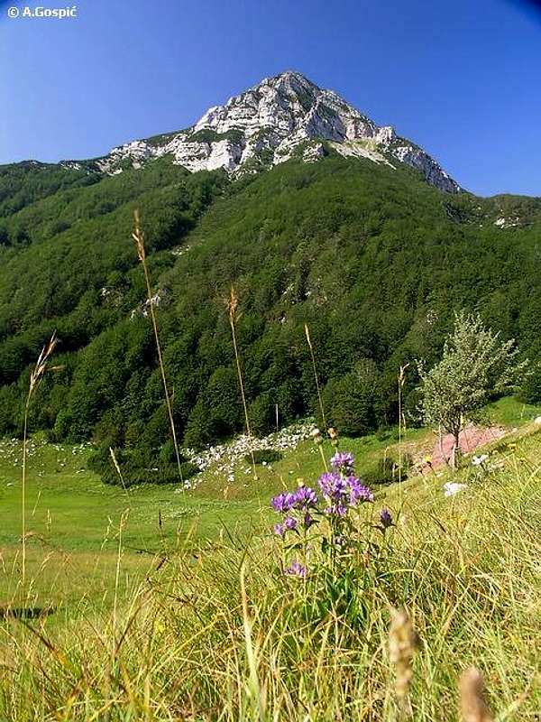 On Bunovac
Bunovac is beautiful, around 2km long grassy karst field, placed on the continental terrace of South Velebit (lowest point is at 1185m). Some of the highest peaks of Velebit, lined up in the continental streak of Vaganski Vrh – Sveto Brdo group, rise above it and provide amazing background. Without doubt Bunovac is one of those very special corners, which are so numerous on huge Velebit and hard to single out. Bunovac is parallel with direction of the mountain, meaning it stretches in NW-SE direction. It is around 200-300m wide. From the NW these peaks tower above it: Segestin (1715m), nameless head 1605m, Malovan (1709m) and nameless peak 1660m. Although Segestin is bit higher there is no doubt that trademark of Bunovac is Malovan, which rises like a perfect pyramid above central part of the field. Whole SW side above Bunovac, including the peaks rises very steeply above. Lower part of the slope is under beech forests with some fir, which quickly shrinks and becomes stunted, retreating in front dwarf pine, while above it all peaks rise with torn white cliffs. Opposite of highest peaks is tame, by beech forested undulating area, which is around 150m higher than Bunovac. It is around 1-2km wide and than it falls towards Lika like cut off. So from all sides Bunovac is closed valley except one narrow passage through continental forested ridge, which open at mid part of the field. This passage is Sijasetska Draga, deep rising valley placed between very steep sides. Through it macadam road approaches Bunovac from Raduc village in Lika.
In the NW edge of Bunovac there is Dolac source, which never dries, and in July has water temperature of only 7.5°C. It makes a short creek which soon goes underground bit lower on the field. In the mid part of Bunovac is its another attraction: Ponor na Bunovcu (hole on Bunovac), which with depth of 534m was for a long time deepest on Velebit. It lost the crown in mid 90’s when many deeper wholes were discovered on North velebit.
Bunovac used to be crossed by marked path which went along whole continental terrace, below highest peaks, on the way from former Stirovac hut to Cicina Dolina junction, via Bunovacka Vrata pass (1620m), where it joined VPP trail, half way between Sveto Brdo and Vaganski Vrh. Unfortunately during 90’s independence war Bunovac was front line between Croats, who held seaboard and top part of Velebit and occupying Serbs, who held continental side and Bunovac was one of their bases. Although there were no battles on Velebit, just minor clashes between patrols, area is to certain degree polluted with mines. Along with Tulove grede cliffs on SE Velebit, Bunovac is probably one of greatest war losses, as it is so beautiful place, now inaccessible.
In 1999 Paklenica NP was significantly enlarged to include highest peaks of Velebit and rightfully so on to continental terrace. So since then Bunovac is part of NP. Hopefully in the coming year’s polluted parts of South Velebit will be inspected and cleared of mines. Then, after longer pause, hikers will again enjoy and admire Bunovac and its fantastic panoramas. Bunovac would also be a fantastic spot to erect a mountain refuge.
 |  |  |  |
Hike Advices
 Towards Vaganski Vrh from Struge in May
1) Daily combinations: any 2 of 4 described routes which lead from Paklenica hut towards Vaganski Vrh can be used for daily ascent and descent. You can also do it from the coast (Starigrad Paklenica or parking in the canyon of Velika Paklenica) but is significantly harder as you add 1000m more of altitude difference which results in more than respectful 3.5km of altitude gained and lost in a day. That is only for those in very good shape. Most beautiful, but also most demanding, route to ascent is the one via Liburnija peak. For descent use any of 3. Lipa Staza is quickest, while via Struge is longest. I would suggest middle one, Bukova Staza route, which is very nice. It is steep but easier on knees than Lipa Staza. If you want to spare your knees as much as possible choose route via Struge.
2) 2 day combinations:
a) on the 1st day climb Vaganski Vrh via Liburnija and descent to Struge refuge where you’ll sleep over. On the 2nd day, before descending to Paklenica and coast, climb Viserujna (1632m) from Buljma pass (see Viserujna Circle route, summit to Buljma pass section).
b) on the 1st day reach Struge from the coast where you’ll sleep over. Take a look at the sunset from Viserujna (1632m) (any location on the ridge between Buljma pass and summit, Debelo Brdo (1602m) presumably). On the 2nd day continue towards Vaganski Vrh via Struge route. From the summit head to Sveto Brdo (1751m) via Vaganski Vrh – Sveto Brdo route. Descent to Paklenica via Velika Paklenica route. This is quite tough 2nd day so you can break it in two by sleeping over at Vlaski Grad refuge.
Note: there are many more hike suggestions in Paklenica area on Liburnija (1710m) &
Sveto Brdo (1751m) pages.
3) multiple areas: if you want to combine multiple areas in 3 or 4 day hikes there are also many combinations. Take a look at Hike Advices sections on Stap, Visocica (1619m) or Viserujna (1632m) & Rujno pages.
 |  |  |  |
Getting There
By PlaneClosest airport is in Zadar, 45 km away. There are no international flights to Zadar (except charter flights during summer season) so you have to go over Zagreb international airport. There are everyday flights from Zagreb to Zadar. Find more info about flights on official site of Croatia Airlines
By Bus
There are numerous bus lines from Zagreb to Zadar each day, almost every half hour. The only problem is in the fact that there is no direct bus to Starigrad Paklenica from Zagreb. Some lines go via highway some use road via Gracac. Those that go via highway don’t stop on Maslenicki Most bridge location so from Zadar you have to take bus back towards Rijeka. Those that go via Gracac stop on Maslenicki Most bridge. Wait there for the bus towards Rijeka or you can hitch-hike to Starigrad Paklenica, which is 15 km from here.
Detailed bus timetables you can find at Zagreb bus station site.
By Train
Train is not a good option if you are coming from Zagreb. It travels longer than bus and you have to change the train in Knin towards Zadar and than take a bus to Starigrad Paklenica. Train timetables can be found on Croatian railways site.
By Car
The best way is to come by car. There are two main directions to come to this area, from Rijeka or Zagreb.
From Rijeka, along the coast:
This route is suitable if you are coming from western Europe, via Trieste (Italy).
Trieste – Rijeka: 70 km
Rijeka - Starigrad Paklenica: 180 km
From Zagreb:
This road is suitable if you are coming from eastern or central Europe via Ljubljana (Slovenia), Maribor (Slovenia) or Budapest (Hungary).
Ljubljana – Zagreb: 138 km, Maribor – Zagreb: 113 km, Budapest – Zagreb: 347 km
Zagreb - Starigrad Paklenica (via Plitvice and highway): 250 km
From Zadar:
Zadar – Starigrad Paklenica: 45km
Look for current road conditions in Croatia on the page of Croatian Automobile Club (HAK).
Maps
Here posted is mountaineering map showing routes leading from Paklenica hut towards Vaganski Vrh. Detailed map of larger area can feet in 640 pixels so for larger area overview see this mapsee this map submitted to Sveto Brdo page. Even wider area mapwith approaching roads can also be found on Sveto brdo page. |
When To Climb
Winter: Vaganski Vrh, as other high parts of Velebit, are under snow from end October till mid May, depends of the year and accumulated snow. In the highest area of the mountain few meters of snow are expected every winter. Drifts can be as high as 15 meters. Coldest months are December, January and February. Temperatures can drop to -30°C. Good days in this period are the clearest in year. If you are lucky to be here during those days experience is unique. You'll enjoy beautiful views from snowy peaks towards sea, islands and many other mountains in Dinaric Alps range. Crampons and are necessary in winter as snow is quickly transformed into hard packed, especially on the ridges. Ice ax is optional but good to have on some more exposed places. Walking poles will do the job most of the time. Most dangerous factor in winter, but also in other parts of the year, is Bura wind. It brings unbearable wind chill effect and sheer strength can blow you off. Strongest recorded gust so far reached 304km/h!!. When Bura blows with such force sustained wind holds around 170km/h or 100mp/h!Spring: is relatively short in high part of Velebit. Here you can expect it from May till end of June. Grass will turn green at the beginning of June, highest forest around May 20th. Even in June snow can easily fall but will quickly melt.
Summer: months are July and August. Weather is generally very good, lot of clear, warm or even hot days. Daily cloud development is expected frequently above highest peaks. Nice cumulus clouds provide nice shade. In July snow is least possible or almost impossible. By the end of August snow can be expected again but it also doesn't last long (1-2 days). Highest temperatures on Vaganski Vrh rarely get above 20°C in July and August. Take at least 2 liters of water per day. No gear is needed in summer, only good hat and Sun factor for protection.
Autumn: months among highest peaks of Velebit are September and October. Highest forest, around Struge plateau for example, has autumn colors at the end of September. Grass is yellow. Last half of October is beautiful period to visit, when autumn colors take over in Paklenica valleys. Among highest peaks is already nice and fresh then and days are very clear.
 |  |  |  |  |
Mountain Conditions
Conditions on Velebit are very well known thanks to Zavizan meteo station, which is observing weather since 1953. On WeatherOnline & DHMZ (Croatian Meteorological and Hydrological Association) sites you can find current data for Zavizan and even forecast for Zavizan on WeatherOnline. Other closer forecast and current data places are Zadar and Gospic towns.Here are the links where you can find out about the current weather on Velebit (Zavizan) and forecast for Croatia:
WeatherOnline:
WeatherOnline home page
Croatia at WeatherOnline,
Zavizan at WeatherOnline
Croatian Meteorological and Hydrological Association (DHMZ):
DHMZ home page
DHMZ Forecast page
DHMZ 7 Day Forecast for Croatian cities and places World wide, including Zadar and Gospic
Current Weather Conditions in Croatia including Zavizan, Gospic and Zadar (from 4-14h and 19-21h, during summer +1hour)
Snow Depth's in Croatia
Objects
Dom u Paklenici (480m) (Paklenica hut) is placed in the beech forest, at the point where Upper and Lower Velika Paklenica valleys touch, just below highest peaks of Velebit. There is plenty of water here year round, which makes it perfect base for dozens daily hikes. Above the hut there is pool in which you can swim in summer. The hut produces its own electricity from the small generator that is powered by water from the creek. There is also satellite phone here, which uses Croatian Telecom calling cards. You can by them in every tobacco shop or gas station (there is no cell phone signal here because mountains are all around). The hut itself has 40 beds in 5 rooms and is supplied with drinks and partially with food, which means it is better to take your own food but if you don't you won't stay hungry. During the season (June to October) and holidays it’s open constantly. The rest of the time it is open from Friday to Sunday evenings. Valter Morovic, president of Paklenica mountaineering club from Zadar, manages the hut.Struge refuge (1400m) is placed on Struge plateau, 15-20mins from Buljma pass (1400m) in the area of meadows and beech grooves which separates lower from upper Struge. Refuge was established after the 90’s war in military refuge. In 1999 huge snow, over 3m, leveled to the ground wooden shack. In 2000 current refuge was erected. Now it has very steep mountain roof. It is open all the time and has enough space to accommodate up to 25 people on two levels. Refuge is equipped with everything one needs to prepare food while stove is used for both heating and cooking. Water is 15mins away towards Vaganski Vrh, in Marasovac well. In winter when well is under snow you have to melt the snow.
 |  |
Camping
Camping inside the national park is forbidden. But there are dozens of camps on the coast in the Starigrad-Paklenica and Seline. Many are concentrated around the entrance in the Velika Paklenica. Also there are Alan, Rajna, Vicko and Kiko hotels etc. in Starigrad Paklenica and many private apartments in both places.More info on accommodations you can find on:
Starigrad-Paklenica riviera site
Adriatica.net, accommodation on Croatian coast
Red Tape
Entrance to Velika Paklenica is 30 Kuna (4 Euro or 5 Dollars). One ticket is worth for two entrances or one entrance with visit to labyrinth bunker in cliffs of Velika Paklenica or Manita Pecina cave. In Velika Paklenica there is no extra fee on parking. If parking inside the canyon is full they will tell you on the entrance to leave the car there. In that case minibus will take you there without extra fee.More information about prices can be found on Paklenica National Park site.
Other Velebit pages on SummitPost
~ Velebit massif, main page, general info~ Zavizan area, North Velebit (Mali Rajinac (1699m) highest peak on the page)
~ Rozanski Kukovi group, North Velebit (Gromovaca (1676m) & Vratarski Kuk (1676m) highest peaks on the page)
~ Alancic / Rozanski Vrh / Seravski Vrh, North Velebit (Goli Vrh (1670m) highest peak on the page)
~ Veliki Kozjak (1629m), North Velebit
~ Satorina (1624m), Mid Velebit (including whole area between it and Alan pass)
~ Stap area, South Velebit, (Debeli Kuk (1269m) highest peak on the page)
~ Visocica (1619m), South Velebit
~ Bojin Kuk (1110m), South Velebit
~ Viserujna (1632m) & Rujno, South Velebit
~ Paklenica area, South Velebit
~ Liburnija (1710m), South Velebit
~ Sveto Brdo (1751m), South Velebit
~ Tulove Grede (1120m), SE Velebit
~ Crnopac (1404m), SE Velebit
Note: Text on this and pages above is copyrighted and cannot be used in any kind of publications.