
-
 47185 Hits
-
 88.61% Score
-
 27 Votes
|
|
Mountain/Rock |
|---|---|
|
|
36.62830°N / 118.322°W |
|
|
Inyo & Tulare |
|
|
Hiking, Mountaineering, Trad Climbing, Scrambling |
|
|
Spring, Summer, Fall, Winter |
|
|
13990 ft / 4264 m |
|
|
Overview
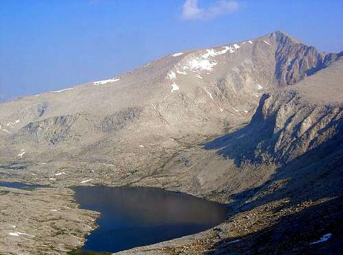
Mount Barnard above Wallace Lake in July
This was not always the case. Earlier in the 20th century, Mt. Barnard was a more popular climb because it was originally measured as a 14er. Later, the U.S Geological survey remeasured Mount Barnard and concluded that its height was “only” 13,990 feet, which of course greatly displeased many climbers.
Mount Barnard was first climbed on September 25, 1892 by John Hunter, William Hunter, W.L. Hunter and C. Mulholland. Most climbers probably use one of the class 2 routes, which involve some talus and scree slogging, and includes approaching via George Creek or the North Fork of Lone Pine Creek, or a traverse from Trojan Peak. There are also four technical routes: the Northwest Face (III, 5.8), East Dihedral (III, 5.10a), East Pillar (III, 5.9) and Shaw Spire (III, 5.8).
Getting There
Mt. Barnard is probably most conveniently accessed as a side trip from the John Muir Trail. With that said, the easiest way to climb Mount Barnard requires over 13 miles of hiking with almost 8000' of elevation gain.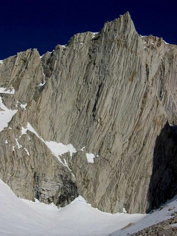
Directions to Get to the Junction of the John Muir Trail and Wallace Creek:
Whitney Portal: To get to the Whitney Portal, take the Whitney Portal Road west from Lone Pine for 12 miles until the road ends. Hike up the Mount Whitney Trail over Trail Crest and pass Guitar Lake and the Crabtree Ranger Station for 15.4 miles until reaching the John Muir Trail. Head north on the John Muir Trail for 3.3 miles until reaching the north side of Wallace Creek.
Shepherd Pass: To get to Shepherd Pass, drive to Independence. From Independence, head west on Market Street for 4.2 miles. Turn left on Foothill Road, which is a gravel road. After driving on Foothill Road for 2.7 miles, you will pass a sign with a hiker symbol on the right and a “Symmes Creek” sign in the center. Keep left and continue for another 0.5 mile. Then, turn right at the intersection where the sign says “Shepherd Pass Trailhead.” Drive another 1.4 miles along a rough gravel road (but still passable with a low-clearance 2wd vehicle) until reaching the trailhead. From the Shepherd Pass Trailhead, hike up for 11 miles to the top of the pass. Then, hike down another 4.2 miles to the junction with the John Muir Trail. Proceed south (left) down the John Muir Trail for 4.7 miles until reaching the north side of Wallace Creek.
Directions up Wallace Creek:
Beautiful Wallace Basin is an easy four mile hike from the John Muir Trail. Despite its proximity to the John Muir Trail, it receives few visitors. Wallace Lake in Wallace Basin is below Mt. Barnard’s southern slopes and is a nice place to camp or kill a day. A good use trail follows Wallace Creek from the John Muir Trail, starting on the north side of the creek. There are also many other great places to camp along Wallace Creek before reaching Wallace Lake.
George Creek: This eastside approach would be among the shortest--approximately 7 miles. I have not taken this approach so I cannot describe it. See this trip report of the George Creek route up Mount Carl Heller or see The High Sierra: Peaks, Passes, and Trails by RJ Secor.
North Fork of Lone Pine Creek: It is also possible approach Mount Barnard via "Russell-Carillon Pass". This would be relatively short--about 10 miles each way--but also mostly cross-country. See this trip report of a daytrip of Mount Barnard via the North Fork of Lone Pine Creek.
Route Overview
| Route Name | Difficulty | Round Trip Distance | Elevation Gain |
| Southwest Slope | Class 1 | ~21 miles | ~9300' |
| South Ridge | Class 2 | ~20 miles | ~9250' |
| Traverse From Trojan Peak | Class 2 | ~14 miles | ~8600' |
| From George Creek | Class 2 | ~13 miles | ~7700' |
| Shaw Spire | III, 5.8 | ~14 miles | ~8000' |
| Northwest Face | III, 5.8 | ~14 miles | ~8000' |
| East Pillar (East Face) | III, 5.9 | ~14 miles | ~8000' |
| East Dihedral | III, 5.10a | ~14 miles | ~8000' |
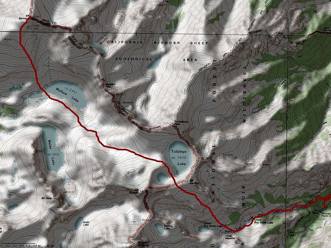
Mount Barnard's South Ridge Route. ~20 miles with ~9,250' of elevation gain. Click to enlarge.
Red Tape
Thanks to The Chief and others, the Bighorn closure is no longer in effect as of December 1, 2010. Access is open to this area year round.Wilderness permits are required for overnight visits from Inyo National Forest. Permits can be reserved in advance for $5/person, which is recommended, especially for weekends and holidays, because most Inyo National Forest trailheads are subject to use quotas. Overnight Whitney Zone entry permits are notoriously difficult to obtain and should, if possible, be reserved several months in advance. They cost $15/person to reserve. There is no fee for permits if they are not reserved in advance.
Bear canisters are required for overnight visitors entering or exiting on the Whitney Main Trail. Bear canister rules are available online. Canisters can be rented at the ranger station. They can also be purchased for a reasonable price at the Whitney Portal Store in Lone Pine and at the Whitney Portal.
When To Climb
May-October are usually the best months to climb Mount Barnard.Camping
Wallace Basin is a true Sierra gem—remote, high, wild, and very beautiful and has several wonderful meadows, lakes and streams. Although Wallace Basin is only 3 or 4 miles from the John Muir Trail, few hikers visit the area. Wright Lakes Basin is also quite nice and can be reached by leaving the John Muir Trail at the Bighorn Plateau near the small pond to the west of the John Muir Trail and heading east for 1.5 miles until reaching Wright Lakes.Mountain Conditions
Sequoia National Park visitor information: (559) 565-3341Inyo National Forest visitor information: (760) 876-6200
Weather
Snow Depth
Eastern Sierra Avalanche Center
Etymology
Mount Barnard was named by its first ascent party: W.L., John and William Hunter and C. Mulholland. The name Mount Barnard was in honor of the Mount Hamilton astronomer, Edward Barnard (1857-1923).Literature
The High Sierra: Peaks, Passes, and TrailsClimbing California’s High Sierra
The Climber's Guide to the High Sierra
Sierra Nevada Place Names
Dayhike up North Fork of Lone Pine Creek - July 12, 2008
External Links
Dayhike up George Creek - May 8, 2004Dayhike up North Fork of Lone Pine Creek - July 12, 2008
Lists of John