
|
|
Mountain/Rock |
|---|---|
|
|
38.06500°N / 119.273°W |
|
|
12374 ft / 3772 m |
|
|
Overview
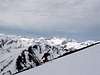
Dunderberg Peak is a large lump of rock east of the Sierra crest near the divide between the Owens and E. Walker Valleys (Conway Summit). Dunderberg Peak doesn't offer much excitement for the hard core mountaineer, but it has several strong points. First, it is close to a major roadway and serves as a great "first summit" for newbie peakbaggers. Second, the peak is located a fair distance off of the main crest, and this location offers unparalleled views for a mere twelve-thousand foot peak. Finally, Dunderberg is a world class ski mountain, with terrific descents off all of its sides. A spring corn skiing trip to the Virginia Lakes area will put a smile on any skiers face.
 |  |  |  |  |
Getting There
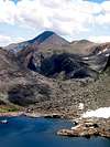
Dunderberg Peak is located about 8 miles west of Conway Summit, near the eastern entrance of Yosemite NP and Mono Lake. The peak is clearly visible on US 395 from as far north as Topaz and as far south as Tom's Place. From 395, head west on the Virginia Lakes road. South and West sides of the peak are accessed from the Virginia Lakes area. The east and north sides of the peak are accessed from Dunderberg Meadow Road, a dirt road that branches north off of the Virginia Lakes road near the base of the mountain.
 |
When To Climb
Dunderberg can be climbed year round, although this becomes more difficult when the Virginia Lakes road is closed (usually November through April), requiring an 8 mile approach on skis or snowshoes (or snowmobile). The road is almost always open by the last weekend in April for the commencement of fishing season. Contact CalTrans for more information. In early season, don't be surprised to see people ice fishing on the Virginia Lakes.
Personally, I think the best time to climb Dunderberg is in April, when the mountain has a nice snowpack that covers the talus. This allows you to kick steps up the peak (crampons may be required) and ski or glissade back down quickly.
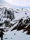
Skiing Dunderberg Peak
As noted, Dunderberg is an extremely good locale for backcountry skiing. The south face of the peak has a steep 2,500 couloir that begs to be skied. This will melt out by late April in a low snow year, and early June in a good year. This route must also be tackled early to avoid slushy snow and wet slide avalanches.
The east face has a moderate and wide gully that drops off from a subsidiary summit of the peak. This is probably the best overall ski route on the mountain. The north face also has great descents, which usually hold snow well into May and June.
 |
Red Tape
The summit of Dunderberg Peak straddles the border between the Toyaibe NF and the Hoover Wilderness. You will not need a permit to day hike this peak. Overnight trips (which aren't necessary) will require a permit if you are camping in the Hoover Wilderness. These can be picked up at the Toyaibe NF Ranger Station 3 miles south of Bridgeport on US 395.
Officially there is no dispersed camping in the Virginia Lakes area. There is one "official" fee-bearing campground at Trumbull Lake.
Trailhead parking is abundant, though you may have to compete with fisherman for spots.
Etymology
Bob Burd adds the following interesting history:
"The peak appears as Castle Peak on Goddard's and Hoffmann's maps. On Sept. 19, 1878, a party of the Wheeler Survey headed by Lt. M. M. Macomb renamed it Dunderberg, after the famous mine on Dog Creek on the north slope of the mountain. This mine was probably named after the Union man-of-war Dunderberg, launched in New York in July 1865. The vessel in turn probably derived its name from Dunderberg mountain in New York state (Dutch for 'Thunder Mountain'). Thus it may well have been that a mountain in California was named after a mountain in New York via a warship and a mine (see Kearsarge). In June 1947 Birge M. and Malcolm Clark of Palo Alto found the following record of the Macomb party in a metal can on the peak: "This peak is called 'Dunderberg' instead of 'Castle Peak' in view of the fact that there is a peak north of Summit Station, Cal., on the C. P. [Central Pacific] R. R. to which the name is more appropriate. Also, because the name 'Castle Rocks' has been given to some peaks north of the Relief Trail at the head of the Stanislaus." The present name appeared on the Bridgeport atlas sheet in 1911.
- Erwin Gudde, California Place Names
mtbaxter - Oct 12, 2013 11:06 pm - Hasn't voted
Mark Twain's book 'Roughing It'Mark Twain wrote of camping at the base of this mountain, then called Castle Peak at the end of his hilarious chapter about Mono Lake. “At the end of a week we adjourned to the Sierras on a fishing excursion, and spent several days in camp under snowy Castle Peak, and fished successfully for trout in a bright, miniature lake whose surface was between ten and eleven thousand feet above the level of the sea; cooling ourselves during the hot August noons by sitting on snow banks ten feet deep, under whose sheltering edges fine grass and dainty flowers flourished luxuriously; and at night entertaining ourselves by almost freezing to death. Then we returned to Mono Lake, and finding that the cement excitement was over for the present, packed up and went back to Esmeralda.” Excerpt From: Twain, Mark. “Roughing It.”