

-
 65923 Hits
-
 94.08% Score
-
 46 Votes
|
|
Mountain/Rock |
|---|---|
|
|
40.26325°N / 105.60707°W |
|
|
13281 ft / 4048 m |
|
|
Overview
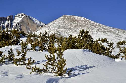
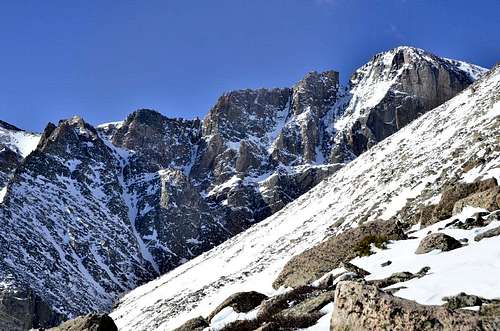
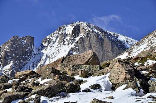
Mount Lady Washington (13,281') is located next to Longs Peak (14,259'), and is one of three peaks that form the Chasm Lake cirque (Mt Meeker,Longs Peak and MLW). No trail leads to the summit, however it’s a relatively short, moderate excursion off the Longs Peak Trail to the top. This mountain may not seem to impressive at first glance. But don't be fooled. It's a wonderful mountain.
, Longs Peak (14,259), Mt. Lady Washington (13,281). Looking West from Hwy 7 just south of Estes Park.")
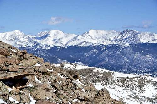
It is nothing more than a tundra walk to the base, then a long boulder hopping scramble to the summit. From the top, there are unmatched views of the Diamond of Longs Peak. Every time I rise over the crest of the summit, this view takes my breath away. The Diamond is HUGE, and makes you feel so tiny.
Not only do you have great views of the Diamond, but the views to the East, of the high plains, are great as well.
This is a pretty heavily climbed mountain, but a lot of people climb it on the way to other peaks, such as Storm Peak, and Longs Peak. This is one of the mountains included in the infamous "Grand Slam" (Meeker, Longs, Pagoda, Storm, and Lady Washington).
Statistics and Information
Summit Elevation: 13821 ft
Location: Front Range, Colorado
Rank in Colorado: 416 of 637
13er Rank in Colorado: 363 of 584
13er Rank in Range: 34 of 59
Mileasge: 11.6 miles (Round Trip)
Total Tme: 8 to 10 hours
Elevation Gain: 3881 ft
|
|
|
Getting There
From Estes Park (intersection of Hwy 34 and Hwy 36):
Take US Hwy 36 east from the intersection of Hwy 34/Hwy 36 (near the McDonald's) for approx 0.4 miles, to the intersection of CO Hwy 7. Take CO Hwy 7 right (south) and proceed south for approx 8.9 miles to the entrance to the Longs Peak Ranger Station and Campground. There is a sign here, and it's a hard right turn after a sweeping left. Turn right and proceed another mile to the trailhead. The campground is on the right and the ranger station and trailhead is on the left.
From Boulder (Canyon and Broadway):
Take Canyon Blvd (Hwy 119) east to US Hwy 36 (28th St). Turn left (north) and proceed out of town on Hwy 36. After approximately 15 miles, you'll near Lyons and come to the intersection of US Hwy 36 and CO Hwy 66. Take a left and continue west on Hwy 36 into Lyons. Total distance from Canyon/28th in Boulder to downtown Lyons is approx 16.3 miles. From downtown Lyons, take CO Hwy 7 west up South Saint Vrain Canyon. At approx 14 miles you'll pass CO Hwy 72 (Peak to Peak Hwy), at approx 18.75 miles you'll pass Allenspark, and at approx 20.5 miles you'll pass the Wild Basin Entrance. Continue on Hwy 7 for a total of approx 24.3 miles from Lyons to the Longs Peak Ranger Station and Campground entrance. There is a sign here, and it's a left turn right before a sweeping right. Turn left and proceed another mile to the trailhead. The campground is on the right and the ranger station and trailhead is on the left.
Please note: You must have a valid backcountry permit for overnight parking. This lot fills very early on summer weekends. You may wind up parking 1/2 mile or more down the road. Observe all no parking signs.
|
|
|
Route

From Granite Pass:
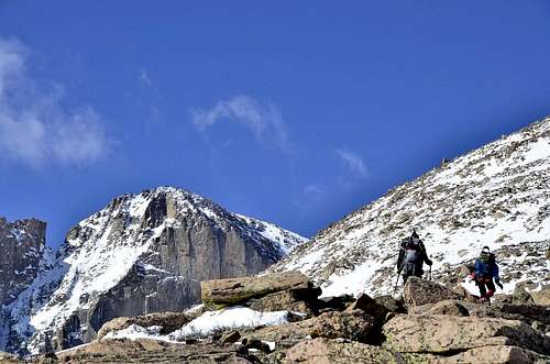
Mount Lady Washington (13,281’) is located 0.5 mile NE of Longs Peak and overlooks Chasm Lake to the south and Granite Pass, 0.75 mile to the north. Starting at the Longs Peak Ranger Station, follow the well-marked Longs Peak trail westward 0.5 miles to a junction with the branch heading northward to the Eugenia Mine and Moore Park. Take the left branch westward past the Goblin’s Forest campground (at 1.2 miles) to the bridge across Alpine Brook (at 2.0 miles). Continue about 0.2 mile to tree-line, another 0.5 mile to the Jim’s Grove campground, and then 0.7 mile along the north side of Mills Moraine to a junction with the Chasm Lake spur trail (11535’, 3.4 miles from the TH). Take the right fork and hike 1.1 miles NW along the shoulder of Mount Lady Washington to windy, Granite Pass. Bear left and climb the rocky switch-backs SW to the northern edge of the “Boulderfield”. After the third switch-back, leave the trail and follow the ridge line 0.8 mile due south to the summit of Mount Lady Washington. From the summit, the normal return is to retrace the ascent route. Descending the east ridge, straight down to the Chasm Lake Junction, saves about 1.2 miles but is steep and rocky.
From Chasm Junction:https://www.protrails.com/gallery/598/colorado/rocky-mountain-national-park/mount-lady-washington
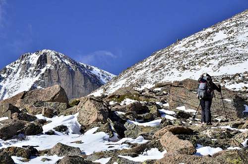
From Chasm Lake trail junction, continuing up the main trail to the Boulderfield, but after just a less than of quarter mile, turn left off-trail and begin to ascend directly to Mt. Lady Washington’s visible summit ridge.
Steep Class 2 Alpine tundra gradually gives way to Class
View of Longs Peak from trail. |
Direct route from Chasm Junction. |
 Route from Granite Pass Route from Granite Pass |
Map
Red Tape
Note: Unlike Longs Peak, Mount Lady Washington can be climbed year round without technical equipment, weather permitting. However, the upper sections of the route are very rocky and require substantial boulder scrambling. Stay alert for thunderstorms which can arise with little warning at any time during the year (but most commonly on summer afternoons). Other common problems arising from the altitude and dry climate include altitude sickness, hypothermia, and dehydration. Regardless of the season, it is important to drink plenty of water, to carry extra layers of clothing, and watch out for any changes in the weather.
Visit Rocky Mountain National Park for all additional information regarding permits, camping, etc
Rocky Mountain National Park Web Site.
External Links