
|
|
Mountain/Rock |
|---|---|
|
|
37.75961°N / 107.6066°W |
|
|
13259 ft / 4041 m |
|
|
Overview
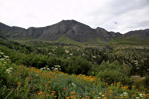
Whitehead is the first peak on the right, from Andrews Lake on Route 550
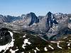
The summit of Whitehead Peak will provide you with one of the best views of the most jagged peaks in Colorado: The Grenadier Range.
Whitehead Peak is the southern-most of a string of 13ers that stretch south of Kendall Peak near the town of Silverton in the San Juan Mountains of southwest Colorado. North to south, these peaks include: Kendall Peak 13451 ft, Peak 13409, Peak 13399, Peak 13434, Peak 13402 and Whitehead Peak.
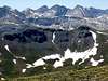
To the west of these 13ers, Animas River has created a deep canyon. From the top of Whitehead Peak, Route 550 can be seen climbing the slopes of Sultan Mountain across the canyon of Animas River. South of Whitehead, the valley of Elk Creek separates the peaks of the Grenadier Range from those of the Kendall Mountain Range. Much of the land to the east of Whitehead is a grassy plateau that is more than 12000 ft high. Countless lakes and ponds are scattered over this plateau. Three of the larger lakes are known as the Highland Mary Lakes and are a fairly popular destination for day-hikers and fishermen.
The shortest way to reach the summit of Whitehead Peak is from the west, via Deer Park Trail which supposedly starts at the end of a branch of Kendall Mountain Road. The most scenic route, however, is from the east via the Highland Mary Lakes.
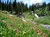
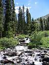
The trail for Highland Mary Lakes starts at the end of Cunningham Creek Road at an elevation of 10800 ft (see Getting There and Routes). The trail follows a stream that makes an almost continuous series of cascades and waterfalls at the bottom of a rocky valley covered with Pine trees. Above timberline, the lakes and the plateau appear rather unexpectedly. The string of 13ers can be seen about 1.5 miles to the west of the lakes. From the lakes, the hike to the summit of Whitehead Peak will take you through green hills covered with vast fields of wild flowers, dotted with ponds and banks of snow.
Although Highland Mary Lakes are popular with hikers, few people go beyond the lakes. This is a beautiful hike that reflects the true majesty of the San Juan Mountains.
 |  |  |  | 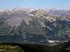 |
 Whitehead Peak from Deer Creek Park
Getting There
From silverton drive the right (and not the left) branch of Route 110, four miles west to the ghost town of Howardsville (a well-graded dirt road passable by any car). Turn right onto Cunningham Creek/Stony Pass Road (also passable by any car). The road splits into two branches that go parallel to Cunningham Creek, one 200 ft or so above the other. You can take either one. They soon rejoin.Continue 3.5 miles (and go past the junction of Stony Pass Road) until you reach where the road crosses to the right side of the creek and becomes 4WD. With 4WD, you can go another mile by crossing the creek over the bridge and going up the little switchback till you see a steep spur road on the left that goes down to cross the creek again. You must turn left here (if you go straight, you will end up in Spencer Basin).
Turn left, go down the hill and cross the creek. There is no bridge here. When I crossed (in July), the water was ankle deep (but obviously can be much deeper). Shortly after crossing the creek, you will reach the well-signed trailhead (10800 ft).
 |  |  |  |  |
Red Tape
No fees or permits for day hikes. |  | 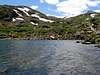 |  | 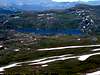 |
When To Climb
Easiest in summer.Click to see the forecast for the town of Silverton.
 (R) Whitehead, (L) Rhoda