
|
|
Mountain/Rock |
|---|---|
|
|
39.31290°N / 105.3813°W |
|
|
9691 ft / 2954 m |
|
|
Lost Creek Wilderness Overview
First, the mountains of the Lost Creek Wilderness submitted here on Summitpost are exclusive to this site. Locating information or any route beta for this area is difficult. Thanks to Jennifer and Gerry Roach's LCW book all of us can view photos and visit these remote summits here on SP.
The Lost Creek Wilderness Area protects nearly 120,000 acres in the Tarryall, Platte River and Kenosha mountain ranges in central Colorado. This relatively new wilderness (designated in 1980) is loaded with hiking, backpacking and climbing possibilities. Typical LCW landscape will consist of mixed and very dense forests, open meadows, and small streams. Upon first sight, it’s possible the casual climber or mountaineer may not be too impressed with the typical LCW mountain configuration. Dense, tree- laden slopes that frequently lead to tree-covered summits could easily rekindle a forgotten bad memory, a memory that includes your most frightening bushwhacking experience.
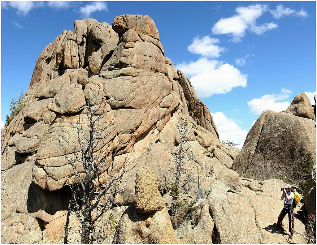
Despite lacking the high alpine scenery of other Colorado wilderness areas, one can argue that LCW is one of the most unique wilderness areas in Colorado. The Lost Creek Wilderness certainly has its own unique character that no other place in Colorado can match. Character that includes some of the most bizarre rock formations Colorado can offer. The heart of the LCW scenery is dominated by twisted rock, which includes massive granite domes and towering granite spires. The highest mountains even sport huge, wide-open plateaus providing easy hiking and excellent views. Getting to those plateaus is another story.
The Castle Overview
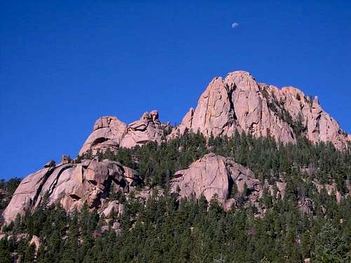
Sweeping up from the sandy beaches of the Wellington Lake, The Castle (9,691-ft)is a well-named collection of high and wild rock spires and craggy points. Located 3.2 miles east of its higher neighbor Windy Peak (11,971-ft), The Castle looks to be protecting the immediate area with its towering pink granite walls. This amazing peak is a completely different kind mountain than Windy Peak, comparing the two is not fair. The Castle is breathtaking to look at, plus it’s the centerpiece of the Wellington Lake area, but Windy Peak provides the tree-laden setting. The two mountains mesh together well, providing grand views and an unforgettable Lost Creek Wilderness experience.
The Castle is not a popular climb, its true summit sees maybe 2 or 3 ascents a year. The Castle is a steep climb requiring two 5.4 crux's; there is no hiking to be had and there definitely won’t be a telescope on the summit to view the surroundings. Usually views like this are enough to deter the adventurous casual day hiker, but surely the symmetry of this peak draws a few unprepared souls to its castle-like ramparts. For those whom make it to the start of the standard southeast gully route, expect an immediate 5.4 move just to get into the gully. Rock climbers will enjoy this fun little mountain; it is a short climb on good rock.
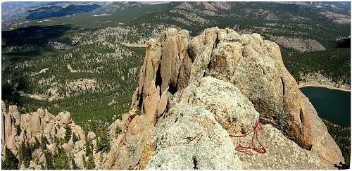
The Castle’s weakness is the southeast gully. This gully consists of one or two difficult moves into the gully, followed by consistent class 3 and 4 climbing. The climbing in this gully is very fun, however it can get tricky. The gully requires solid route finding skills to keep the difficulty at class 3 and 4. In typical Lost Creek Wilderness fashion, the gully abruptly ends at a beautiful flat hanging garden surrounded by 5 or 6 different summits. You could literally set up a tent and picnic table in there.
In Gerry and Jennifer Roach’s excellent LCW book, they note the actual true summit is the north summit, which is a few feet higher than the easier east summit. Attaining the east summit is an easy class 3 scramble from the gardens. Attaining the true summit or the north summit requires first climbing a tree, and finally making one last 5.4 move onto the small summit area.
Welington Lake TH
From Denver Colorado, travel Hwy 285 past Aspen Park, Conifer, Pine Junction and on to Bailey. The very steep "Crow Hill" descends to the town of Bailey. Once you have descended Crow Hill; look sharp to your left for Bailey Propane and Sully's Restaurant, Park County 68 starts here. Turn left on Park County 68; this road is paved for the first 1. 2 miles.Afterwards, the road is a very well maintained dirt road; it is still Park County 68. At 5 miles stay right at a junction. You will be following the "Wellington Lake" road. At 8 miles you will reach a junction with the Rolling Creek TH and the Colorado Trail. Continue south on FS 543 or Park County 68 (the same road here) another 3 miles to the Castle Mountain Recreational Company and turn right into the parking area. Pay your $5.00-day use fee in the office here. The rates for seniors and children are lower but expect to pay an entrance fee.
Continue .06 miles northwest (right) along the lakeshore, bypassing some camp spots. Continue south another .05 miles around the lakeshore to the end of the road where there is plenty of parking. You can see the gates of the Boy Scout camp here and The Castle soars above you from this point.
Regional Weather
Click image to enlarge
Wellington Lake Camping
This beautiful private lake is about 12 miles south of Bailey on Park County Road 68. It is a popular campground especially on the weekends due to its proximity to Denver, Co.-Tents and smaller campers (no hookups) are welcome.
-Picnic tables and fire rings available at each site.
-Some sites are open, some sites are treed.
-There is a beach area.
-No motorized boats on the lake.
-Fishing is allowed.
-Entry fee required.
-Canoes and paddle boats available for rent or bring your own for a daily fee.
Call 303-838-5496 for more information.
Jeremy Hakes - May 23, 2008 4:57 pm - Voted 10/10
Daily Use FeeThe daily use fee has increased to $6/person, as of '08. Seniors and youth discounts still apply - $4/person use fee. Also, evidently a mountain lion has taken the canyons and gullies surrounding The Castle to residence. Solo hikers/climbers should be aware.
Sarah Simon - Oct 7, 2013 1:35 am - Hasn't voted
Update to Red TapeNote updates (Oct 2013) to seasons of operation (1 Oct = winter) and fees ($9/adult/day), plus website info: http://images.summitpost.org/original/870775.JPG Sarah