
-
 29664 Hits
-
 95.51% Score
-
 53 Votes
|
|
Mountain/Rock |
|---|---|
|
|
38.00400°N / 107.771°W |
|
|
Ouray |
|
|
Hiking, Mountaineering, Skiing |
|
|
Spring, Summer, Fall, Winter |
|
|
13686 ft / 4171 m |
|
|
The original site was developed by Aaron Johnson. I adopted this mountain from the orphanage site. The text was completely erased. I hope that below information will be a sufficient replacement of the previous description. Thanks for visiting. ![Cirque Mountain]()
Cirque Mountain as seen from Mount Ridgway![Cirque Mountain]()
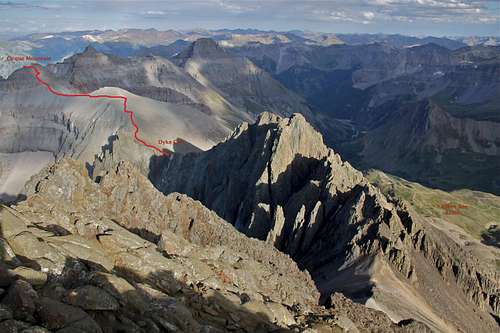
Cirque Mountain's summit as seen from the approachCirque Mountain is a 13er in the Sneffels range of San Juan Mountains. It is a non-technical peak, about class 2 scramble with a few class 2+/3 moves near its top.
Overview
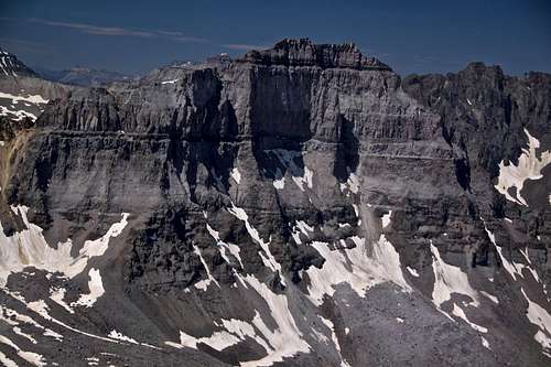
Cirque Mountain as seen from Mount Ridgway
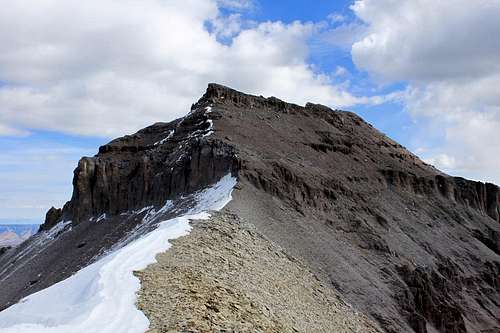
Cirque Mountain's summit as seen from the approach
Guide to the Colorado Mountains with Robert Ormes (sort of a bible of Colorado mountains) provides only a brief description:" Cirque Mountain is 1.2 miles east of Mount Sneffels on the continuing range crest. It has a gentle west ridge, but a rougher summit. The prominent cliffs when viewed from the north in Blaine Basin, given obvious significance to the mountain's name. It is best approached from Dyke Col and the ridge".
The San Juan Mountains: A Climbing and Hiking Guide by Robert Rosebrough mentions Cirque Mountain on several pages. First, on climbing history of Sneffels range it is written that Williams, Griffith and Lavender made probable first ascents of Kismet by its east ridge and Cirque Mountain by its west ridge.
For the route description, it describes Southwest Ridge - From Dike Col the summit of Cirque is one of the few walks ups in the area. Point 13,500 is bypassed to the left (north). you will encounter a ver short section of scrambling at 13,400 feet, just below the summit. The register is on the western summit.
Nearby peaks: (please note one fourteener, one centennial peak and a number of bicentennials)
Colorado Rank: 155 (bicentennial peak = among the highest 200)
Line Parent: Teakettle
Class: 2+
Nearby peaks: (please note one fourteener, one centennial peak and a number of bicentennials)
- Teakettle Mountain (13,819 feet = 4112 meters) 0.6 miles
- "Kismet" unranked peak, (13,694 feet = 4174 meters) 0.76 miles
- Mount Sneffels (14,150 feet = 4313 meters) 1.2 miles
- Mount Ridgeway (13,468 feet = 4105 meters) 1.23 miles
- Stony Mountain not even 13er, but very interesting summit (12,698 feet = 3870 meters)
- Potosi Peak (13,786 feet = 4202 meters) 1.55 miles
- Gilpin Peak (13,694 feet = 4174 meters) 2 miles
- Whitehouse Mountain (13,492 feet = 4112 meters) 2.16 miles
- Mt. Emma (13,581 feet = 4139 meters) 2.23 miles
- Mendota Peak unranked (13,275 feet = 4046 meters) 2.97 miles
Dyke Col is 13,040 foot pass between Kismet and Cirque Mountain. Though steep on the north side, it is a route between Yankee Boy Basin and Blaine Basin. It is named for the prominent rhyolite dyke on the Blaine Basin side. Dyke Col is also popular with back country skiers in May/June when the road to Yankee Boy opens, and is usually plowed to the "toilet trailhead".
![undefined]()
Overview of peaks as seen from the slopes of Mount Sneffels
![4 WD road to Yankee Boy Basin]()
Scenic Road to Yankee Boy Basin ![Scenic road]()
1st section of the road is easy, higher up definitively 4WD high clearance car needed
From the town of Ouray, head south on US. 550, and turn right onto the Camp Bird Mine road. Cross the upper bridge over the Box Canyon at continue on the dirt road up Canyon Creek to a junction at 4.9 mile. Take the right fork (marked for Yankee Boy Basin), and head up Sneffels Creek to a parking area after 8.3 miles, at 11,350 feet. Note the road becomes progressively rougher as you proceed, and to drive to the parking area mentioned requires a four-wheel drive vehicle. There is a composting outhouse at the parking (= toilet trailhead). You can either park here, or continue further up the road if you have high clearance 4WD vehicle. Higher you go, rougher the road gets. You can opt to park at any chance you get per your comfort level of this road. I have driven all the way to the end, and if you want to make your outing as short as possible, continue until you get above the Wright's lake. Look for any pull out space and park.
I would like to mention that the road is very popular with jeeps and 4WD vehicles in the summer, and many companies based in Ouray operate trips into Yankee Boy Basin. Weekends can be pretty busy with traffic (and loud too). I prefer exploring this area off season or in the middle of the week. Also, the road is narrow at the higher sections and passing other vehicles is nearly impossible, so be prepared that you can get stuck in a traffic on summer weekends.

Overview of peaks as seen from the slopes of Mount Sneffels
Getting There

Scenic Road to Yankee Boy Basin

1st section of the road is easy, higher up definitively 4WD high clearance car needed
From the town of Ouray, head south on US. 550, and turn right onto the Camp Bird Mine road. Cross the upper bridge over the Box Canyon at continue on the dirt road up Canyon Creek to a junction at 4.9 mile. Take the right fork (marked for Yankee Boy Basin), and head up Sneffels Creek to a parking area after 8.3 miles, at 11,350 feet. Note the road becomes progressively rougher as you proceed, and to drive to the parking area mentioned requires a four-wheel drive vehicle. There is a composting outhouse at the parking (= toilet trailhead). You can either park here, or continue further up the road if you have high clearance 4WD vehicle. Higher you go, rougher the road gets. You can opt to park at any chance you get per your comfort level of this road. I have driven all the way to the end, and if you want to make your outing as short as possible, continue until you get above the Wright's lake. Look for any pull out space and park.
I would like to mention that the road is very popular with jeeps and 4WD vehicles in the summer, and many companies based in Ouray operate trips into Yankee Boy Basin. Weekends can be pretty busy with traffic (and loud too). I prefer exploring this area off season or in the middle of the week. Also, the road is narrow at the higher sections and passing other vehicles is nearly impossible, so be prepared that you can get stuck in a traffic on summer weekends.
Red Tape
There are no fees to drive into Yankee Boy Basin. Parking is free, as well as climbing and hiking. 4 WD vehicle is required to drive higher up on the road and keep in mind that the road is closed during the winter.Many people drive to Yankee Boy basin in July and August to view wildflowers.
![Road to Yankee Boy Basin]()
Road to Yankee Boy Basin in the winter![Fall colors]()
Fall colors
The easiest time to climb Cirque Mountain is July, August, and September. The mountain should be free of snow, but as I mentioned Dyke Col (the col between Kismet and Cirque is popular with back country skiers), and the most skiers tend to come there in May and early June - the road gets usually cleared off snow up to the "toilet trailhead" at 8.3 miles from Ouray. The road is kept open during the winter up to Senator Gulch about 4.0 miles from Ouray. So, the mountain can be climbed any time of the year, it just depends how much effort you want to put into your approach.
When To Climb
Road to Yankee Boy Basin in the winter
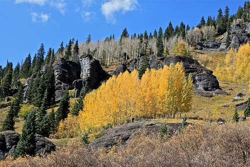
Fall colors
Please check avalanche conditions if traveling in the winter time. North San Juan Colorado Avalanche Center
There is a sign in log on the top of the mountain, and a large cairn.
Watch for the weather. A long section of your hike is above 13,000 feet.
The approach from Blaine Basin is longer, but if you are into backpacking, and more rugged approach avoiding Camp Bird Road traffic, this could be your route. There is a faint steep trail leading to Dyke Col and then the trail joins with Yankee Boy trail.
The ridge between Teakettle and Cirque is very loose and steep, dangerous to negotiate. Protection for 5th class climbing is nearly impossible.
![Overview of the route]() Overview of the hike
Overview of the hike
Images from hike and summit
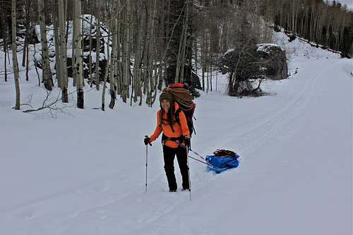
![Winter Mountaineering]()
Winter Mountaineering ![Snow camping]()
Camping below Yankee Boy Basin
Camping is not officially allowed in Yankee Boy Basin (camping is restricted because of the heavy use of the area), but I have spend a few nights in my car parked along the road, and even at the high parking lot at the end of the Camp Bird Road. I have camped in Governor Basin - below Yankee Boy basin in winter (had to snow shoe in since the roads were closed).
There are two official campgrounds in the lower section of Camp Bird road:
Thistledown Camground
Angel Creek Campground
And remember, the town of Ouray offers plenty of different style of accommodations, including soaks in hot springs.
Route
The easiest route - Southwest Ridge - starts in Yankee Boy Basin and leads up to Dyke Col, 13,040 foot high. There are some grassy slopes on this first section of your hike, which are much easier to negotiate compared to scree slopes waiting for you higher up. The photo below shows the overview of the higher section of your hike. There is a faint trail and some scattered cairns. The trail continues on the north side of a small 13,000+ sub peak. From there, it is obvious where to go - just follow along the ridge to the main summit of Cirque Mountain. There are some short 3rd class moves on this section of your hike and a few switchbacks below the summit. The views from the summit are amazing! Enjoy it.There is a sign in log on the top of the mountain, and a large cairn.
Watch for the weather. A long section of your hike is above 13,000 feet.
The approach from Blaine Basin is longer, but if you are into backpacking, and more rugged approach avoiding Camp Bird Road traffic, this could be your route. There is a faint steep trail leading to Dyke Col and then the trail joins with Yankee Boy trail.
The ridge between Teakettle and Cirque is very loose and steep, dangerous to negotiate. Protection for 5th class climbing is nearly impossible.
 Overview of the hike
 Grassy slopes towards Dyke Col Grassy slopes towards Dyke Col |  Dyke Col 13,040 feet Dyke Col 13,040 feet |  Trail higher up Trail higher up |  View back towards Sneffels View back towards Sneffels |  Trail to Cirque with Sneffels in the background Trail to Cirque with Sneffels in the background |
 Sarah Thompson on the summit Sarah Thompson on the summit |  Duchess near the summit Duchess near the summit |  View towards Teakettle and Potosi View towards Teakettle and Potosi |  Gilpin Peak and Mount Emma Gilpin Peak and Mount Emma |  Best hiking buddy Best hiking buddy |
Camping
Winter Mountaineering

Camping below Yankee Boy Basin
Camping is not officially allowed in Yankee Boy Basin (camping is restricted because of the heavy use of the area), but I have spend a few nights in my car parked along the road, and even at the high parking lot at the end of the Camp Bird Road. I have camped in Governor Basin - below Yankee Boy basin in winter (had to snow shoe in since the roads were closed).
There are two official campgrounds in the lower section of Camp Bird road:
Thistledown Camground
Angel Creek Campground
And remember, the town of Ouray offers plenty of different style of accommodations, including soaks in hot springs.