
|
|
Mountain/Rock |
|---|---|
|
|
66.44000°N / 65.16°W |
|
|
6610 ft / 2015 m |
|
|
Overview
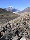
Mt. Asgard also known as 'Sivanitirutinguak' (by the Inuit) is located in Auyuittuq National Park on Baffin Island in the territory of Nunavut. Auyuittuq’s 19700 square kilometers (pronounced eye-you-ee-took) was set aside as a National Park Reserve in 1976, the name Auyuittuq is an Inuit word which when translated means ‘the land that never melts’, which is more than an apt term for the place.
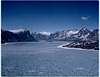
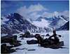
Auyuittuq Park is located on the Cumberland Peninsula on Baffin Island, which is the sixth largest island in the world. The park straddles the boundary of the Arctic Circle, the Penny Ice Cap flows through much of the park and is in places over 300 meters deep. Asgard is located in the Penny Highlands along the side of the Akshayuk Pass which is the 100km long pass (that crosses the Cumberland peninsula between Cumberland Sound and Davis Strait) one hikes form one end to the other where you usually arrange for transportation back to Pangnirtung or can return back along the valley to where your transport back to the town will meet you.
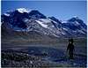
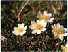
In the summer though the valleys are free of ice and snow and come alive with arctic poppies, you can spot Polar bears close to the water as well as snowy owls, ptarmigan, arctic fox and hares as well as large herds of caribou.
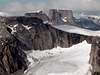
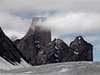
Auyuittuq is home to the highest concentration of high peaks in eastern Canada with 10 peaks rising 2000 meters or higher and dozens that are 1800m or higher. The highest peak in the park is Mt. Odin which rises 2147m and is the fifth highest point in Eastern North America.
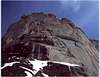
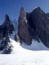
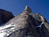
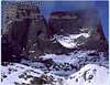
Like many of the peaks in the park Asgard takes its name from Norse mythology. Asgard was the ancestral home of the Norse Gods and the home of slain heroes fallen in war, its twin 1000 meter high cylindrical, granitic towers along with the awesome faces on Breidablik and Mt. Thor have caused many to compare the region to the area around Cerro Fitz Roy in Argentina.
Mt. Asgard towers 2015m, the fifth highest peak in the park and making it one of the highest peaks in Eastern Canada and Eastern North America. What sets Asgard aside is many things… its sheer size… towering 1600m above the valley floor. Its twin 1 kilometer vertical faces, its shape.. which is similar to two huge tree trunks rooted in the very rock of the earth. Its impossible for the eye not to be drawn to it, to want to drink in its majesty, its sheer rugged beauty.
Auyuittuq is home to some of the most remarkable mountains and cliff faces on earth, it is a land of superlatives and Asgard is most assuredly one of it’s crown jewels.
Mt. Asgard’s North peak was first climbed in 1953 by an Arctic Institute of North America Party. The south summit (the more cylindrical of the two with the daunting sheer face) was first reached in 1971 by a party lead by Doug Scott. On Asgard’s west face (North Peak) there are several grade VI routes which have been established for the rock climber eager for a very serious challenge. Even more so than the Cirque of the Unclimbables this is Canada’s rock playground. There is enormous potential here for climbing and because of its remoteness and inaccessibility one will for the most part have the place to themselves.
There is only one designated campsite in the park, the rest of the campgrounds are known as random sites. The one thing to be watchful for is to not camp too close to the Weasel River which cuts through the valley, as it is known to have a 10m range between high and low tide.
The scale of the place is truly awe inspiring and the serenity is almost eerie. Nunavut is close to the size of Mexico yet has a population of around 35000, which are mostly Inuit. The Inuit or their ancestors the Thule moved onto Baffin Island around 800 years ago and have called this land that never melts home ever since.
***Note: all photos were used with permission by Neil Monteith.
*** Note: you may have seen Mt. Asgard in the James Bond film The Spy who loved Me... part of the movie was filmed there
 |  |  |  |  |
Getting There
This is most assuredly the most difficult part, the costs involved can be somewhat prohibitive. Tour groups offer 15 day tours which can run in excess of $5000 CDN easily for winter visits and in the summer you will pay between $3000 and 3500 for trips ranging from 10 to 16 days with groups of no more than 10 or so.. You can check out www.adventures.ca to get a better idea of what is offered in a tour.The trick is to arrange a flight into Pangnirtung or Iqaluit the capital of Nunavut, quite often by way of Churchill Manitoba, Ottawa or Montreal...
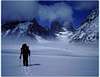
To say that Auyuittuq is off the beaten path is more than a little understatement. It is incredibly remote. From Pangnirtung one must take a 30km boat ride if the Fjord isn't frozen (or one must make the trip by snowmobile) to the park entrance at the head of the Akshayuk Pass which was once known as the Pangnirtung Pass, cuts across the Cumberland Peninsula and is the main travel route year round, though most especially in winter. The park entrance is located here at the head of the valley and here is located the one and only Ranger Station in the entire park.
The Weasel And Owl rivers flow through the valley, and one has to ford the river as well as several runoff streams as you make your way along the valley floor. The trail is marked by ‘Inukshuks’ which are man shaped cairns that are placed at distant but regular intervals so one doesn’t lose their way… though that is kind of hard to do. As the route only follows the valley to its terminus.
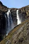
Along the way you can take time out to climb Breidablik, Baldr, Thor or Asgard peaks or head up one narrow valleys to view 680m (2250ft) high Schwarzenbach Falls (one of the highest in Canada) which tumble in three or four glorious stretches to the foot of the mountains.
For more information on routes or on getting there you can check out www.bivouac.com, though to view this material one must be a paid member.
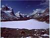
Asgard is located near the Glacier Lakes region right near Summit Lake. To reach its base you have to come prepared to cross Caribou glacier which involves snow up to the knees or even the waist in June or even into mid July.
I don't have a lot of info. on routes and because they are rock climbing routes on challenging walls I won't be posting any routes. Though I will gather what info. I can on the 'Swiss route' a route used by Neil Monteith and include it here in the text. This is probably the easiest path up to the top of the of the North Peak and still requires over 10 pitches and 250 meters of wall climbing plus a lot of serious scrambling just to reach it... a twelve hour day or more for most.
Asgard has incredible climbing potential and has several Grade VI aid routes which have already been established.
 |  |  |  |  |
Red Tape
Yes permits are required, they can be purchased for either $15 a day or an annual permist can be purchased for $100 at the Parks Visitor Information Center in Pangnirtung. For more info. you can call 1 867 473 8828 or try nunavut_info@pc.gc.ca. There are no real seasonal closures to speak of... though very few would want to visit the area in the dead of winter as temperatures hover for weeks on end around -40 degrees celsius or colder. Winter expeditions head up usually in late March or April when winter begins to loosen its icy grip just a little.
Its asked that you stick to walking across rock, sand or snow especially if wildflowers and other rare Arctic plants are out and that you leave the local animals alone. Please also be sure to pack in what you pack out... this is raw unspoiled wilderness at its finest... please respect that.
 |  |  |
When To Climb
The best time for climbing is the summer months between mid June to mid August though one can stretch the season earlier in June or later into the first week of September if the weather holds.
The greatest obstacle to overcome in any other season is winter itself and of course the usual logistical difficulties.. such as arranging transportation, local guides etc. this can all be compunded infinitely by the return of storms to the area. I haven't heard whether there have been early spring climbs or not though I believe it is possible though the costs and logistics would be more than a little prohibitive.
 |  |  |  |  |
Camping
Camping is allowed. The only official site is near the entrance to the Akshayuk Valley near Overlord Mountain. The other sites are officially termed random sites which means camp where you find a good spot. Preferably not too close to the Weasel or Owl rivers and somewhere sheltered as the wind is known to really whip down through the valley. There is a small hut locted near the base of the mountain which can sleep 2-4 people. There are huts located near Mt. Thor and at the park entrance near Mt. Overlord.
 |  |  |  |
Mountain Conditions
The only phone number to call for up to date conditions is the one already provided in the red tape section, and the web address provided should also yield relatively accurate weather conditions. The other web site you could try is the Parks Canada website which is www.pc.gc.ca/auyuittuq. The phone number provided is for the Park superintendent so it should be relatively easy to discover the weather conditions from there.
Failing all of this you could try www.theweathernetwork.com and type in Iqaluit it will give you up to the hour weather conditions.