
|
|
Mountain/Rock |
|---|---|
|
|
37.31960°N / 113.4915°W |
|
|
10365 ft / 3159 m |
|
|
Overview
In southwestern Utah, approximately 15 miles northeast of St. George. Signal Peak is located in the Pine Valley Mountains in the Dixie National Forest. Signal is supposedly named because of its use in World War II when beacons were placed on the mountain to guide airplanes at night. Newly created legend has it that Signal Peak still acts as a beacon to Utah county peak baggers. Signal Peak is the highest point of the Pine Valley Range, which dominates the skyline north of the city of St. George in southwestern Utah.The trail from Oak Grove (southeast approach) to the peak, transition you from a desert environment to a lush pine forest with running water at “Further Water”. Signal peak is also the highest point within Washington County. The view east towards Zion and the western edge of the Colorado Plateau are spectacular.
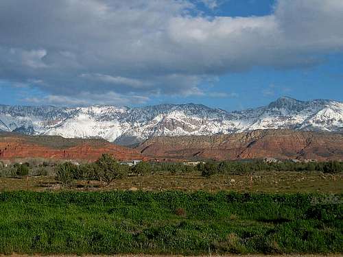 Taken from I-15 near Leeds, Signal Mtn and the Pine Mtn range provide a snowy contrast to the multicolored rocks of southern Utah.
Getting There
OAK GROVE TRAILHEADLeave I-15 at exit 23 (Leeds) in Utah and head west (not east towards Leeds) on Silver Reef Road. You will drive west for 8.6 miles to the Oak Grove trailhead within the Oak Grove Campgrounds. At about 3.1 miles a “Y” is encountered, stay right, left will take you to St. George, continue west for the remaining distance to the trailhead.
BROWNS POINT AND FORSYTH CREEK TRAILHEAD
From SR 18 and the town of Central, Utah head east for 6.9 miles to a sharp bend in the road, stay straight for another 3.5 miles while passing the Pine Valley Reservoir to the Browns Point Trailhead on the right. The Forsyth Creek Trailhead is just short of the Browns Point Trailhead and is at the Equestrian Campground.
 The Pine Valley Mountain range with Signal Peak on the right as seen from near Diamond on Highway 18.
Routes Overview
The Oak Grove Route is the shortest route, but it is steep in places. The route approaches the mountain from the east, climbs the steep escarpment to the plateau rim where the angle of the slope eases. From there, the route follows the Summit Trail south and over a minor divide to a nice meadow containing Further Water Spring. After following the Summit Trail a short distance, the route heads cross-country to the summit.There are other routes from the west to Further Water and Signal Peak. These routes are a bit longer, but less steep and there is much more shade available if it is summer. One of these trails is the Browns Point Trail which joins the Oak Grove Trail at the Summit Trail not far from Further Water. The other trail is the Forsyth Creek Trail which follows Forsyth Creek to past Burger Peak before heading east towards Signal Peak.
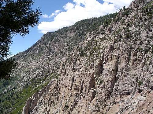 From high on the Oak Grove trail looking west along the crest.
Red Tape
No permits are required.When To Climb
The lower elevations of the mountain can be warm in July and August. Snow last into June on the higher slopes. June, September, and October are probably the best months to climb. In winter, the western approach through Pine Valley would be easier since the Oak Grove trail crosses some very steep terrain before reaching the plateau rim. Nearing the crest line of the Oak Grove trail in summer.
Camping
CAMPING AT THE OAK GROVE CAMPGROUNDCAMPING AT PINE VALLEY CAMPGROUND
Another good area to camp would be at the spring known as Further Water, along the forested edge of the large half mile long meadow.
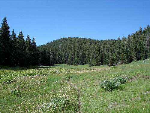 Further Water valley looking directly at Signal Peak.
Mountain Conditions
WEATHER FORECAST FOR SIGNAL PEAKBelow is the climate summary for nearby Brian Head at 9770 feet elevation. These are all averages, so expect more variation, but this will give you a good idea about the climate at higher elevations around Signal Peak. *National Weather Service Data 1991-2004.
| MONTH | HIGH | LOW | SNOW DEPTH | DAYS W/PRECIP |
| JAN | 29 | 10 | 48" | 12 |
| FEB | 32 | 10 | 60" | 13 |
| MAR | 38 | 14 | 71" | 11 |
| APR | 43 | 19 | 72" | 11 |
| MAY | 53 | 27 | 38" | 8 |
| JUN | 64 | 35 | 8" | 5 |
| JUL | 70 | 41 | 0 | 10 |
| AUG | 68 | 42 | 0 | 12 |
| SEP | 60 | 34 | 0 | 8 |
| OCT | 48 | 24 | 4" | 8 |
| NOV | 34 | 14 | 20" | 10 |
| DEC | 28 | 9 | 36" | 11 |