
|
|
Mountain/Rock |
|---|---|
|
|
40.37260°N / 112.1881°W |
|
|
Spring, Summer, Fall, Winter |
|
|
10620 ft / 3237 m |
|
|
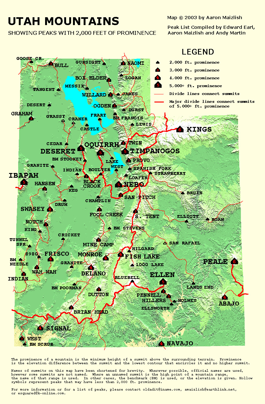
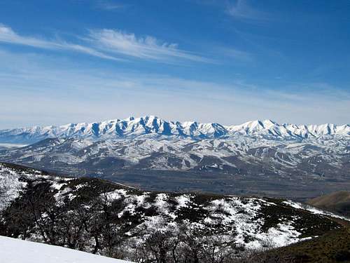
The Oquirrh Mountain range
Update: Read the RED TAPE section for the latest update on getting permission to hike this mountain.
Overview
This mountain is the Rodney Dangerfield of Utah. It really doesn't get any respect. Everyone has seen this mountain but very few even know that they are looking at a significant mountain in its own right. Located close to Salt Lake City and overlooking Lehi , American Fork and the northern Utah county area, it is even overlooked by those who are headed west to climb Deseret Peak. Yet, it is a lofty mountain and a fantastic viewpoint. Once you know what you are looking at, you see it from everywhere in the greater Salt Lake Basin area. Also nearby is theslightly lower Lowe Peak, only 31 feet lower than Flat Top but another worthy goal of this range.
Flat Top is a name that is somewhat misleading. Why it was named Flat Top is beyond me but that is the name this peak is stuck with. Why is this peak significant? Well, for starters it is the highpoint of the Oquirrh mountain range.
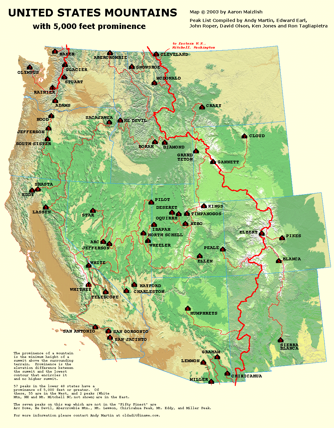
What really makes it special is the fact that it is one of the 57 mountains in the lower 48 that has 5000 feet of prominence. Prominence? What does that mean? Stay tuned, I'll get you to an explanation of this little known concept
in a minute.
Flat Top is one of the eight 5K prominence peaks in the state of Utah. Aaron Maizlish has put together this fantastic map of the Western United States showing the peaks that qualify for this special rating. More information on prominence can be found at
this site, peaklist .org Check out all the maps they have put together, it'll keep you busy on a rainy weekend.
Utah has 8 5000K prominence peaks:
Kings Peak
Mt. Peale
Mt. Ellen
Mt. Nebo
Mt. Timpanogos
Mt. Ibapah
Deseret Peak
Flat Top Peak (in the Oquirrh mtns)
Flat Top ranks 6th in the state of Utah in the terms of prominence (there is that word again)
The Oquirrh mountains are pretty much taken for granted by Salt Lakers and most of it is privately owned. The name Oquirrh (pronounced O-Ker) was taken from the Goshute Indian word meaning "wooded mountain".
The Utah History Encylopedia has this information about the Oquirrh's.
"The first attempt to settle in the Oquirrhs occurred in 1848. At that time two Mormon pioneer brothers, Thomas and Sanford Bingham, set up camp at the mouth of Bingham Canyon. They had been sent to the area by Brigham Young, who had requested that they take a herd of horses and cattle belonging to himself, the Bingham family, and others, up to the high land around the main canyon. For the next year or so, the Bingham brothers spent their time in what became known as Bingham Canyon, herding cattle and, to a limited degree, prospecting for valuable minerals. Some ores were found, but the brothers were advised by Brigham Young not to engage in mining at that time. The ore finds were soon forgotten after 1850 when the Binghams left on a mission to settle Weber County. For the next decade, the Oquirrhs continued to be used as a grazing ground as well as a valuable source of timber for the Mormons."
More history can be found at this website
Particularly interesting in the above reference is the reference to the town of Ophir. Ophir is a well kept secret and yet a fascinating little town to visit.. I had no clue it even existed until I actually drove through it.
Here is a great LINK to more about the interesting town of
OPHIR. This link has pics and info about the town that
make it a worthwhile read.
Getting There
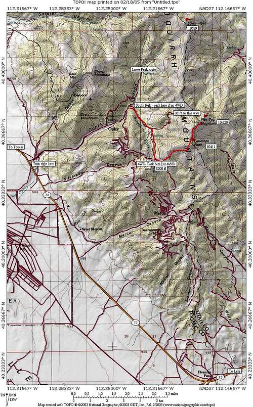
Leave I-15 as you head south from Salt Lake City or north from Provo at the town of Lehi, turning west on highway 73. Proceed west on 73 for close to 28 miles (not exact) with the road going over Five mile pass. Watch the mile posts as the road you need for the turnoff to Ophir (on the right) is between mile posts 4 and 5. I wasn't driving so I can't say for sure the exact mileage but this is in the ballpark. The turnoff to Ophir is paved all the way to Ophir, about 5 miles to the east. Ophir is an old mining town that has given way to private homes and a little bit of restoration, just enough to capture the interest of the average tourist. Go slowly through town and after about 1.2 miles watch for a rough road taking off to the right. It is just before the water from Ophir Creek is diverted into a pipe. If you go past this turnoff, you'll find the road narrows and turns slightly north. Stop and go back.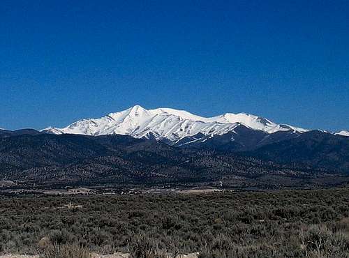
The road up to Flattop is on BLM land while the majority of the area is privately owned and it is important that you stay on BLM land as the landowners are not friendly to those who trespass. The majority of the land is owned by one family nowadays, the Ault family. As one local told us, they own the land for "57 canyons worth". The road you want is the "South Fork" road but I don't recall seeing any signage. Unless you have a high clearance 4WD rig, find a spot to park (off the roadway) and proceed to walk because the road goes to hell in a hurry. We managed to drive this road in Bob Bolton's 4runner but most vehicles would not make it. Trust me when i say this road is nasty. If you park, you will be at an elevation of 6725, leaving you close to 3900 feet of elevation gain . Walk or driving, go right when you hit a junction (see map)
If you go left at this fork, you will eventually come to a gate that will block any further progress and this is where the BLM right of way stops and private property begins. Do not go past this gate. The road beyond leads up to Halls Basin which was described as a possible route in Kelsey's book but is no longer available. At the fork, go right and continue uphill up the south fork road, and you will be able to eventually make it to a pass close to 8000 feet, reducing your effort by almost 1300 feet. There is a small spur road that proceeds up a bit further, if you can get up that spur, you will find a nice spot to park that is out of sight and off the main track. At that spot, you will see a BLM marker that states "No motorized vehicles beyond this point". Walk up the remaining bit of road to another clearing (only about a 100 feet) and look for some rocks piled on top of each other. This marks the beginning of a trail that you could miss if you don't pay attention and that trail makes a big difference. This is the beginning of the Lewiston Peak route (see routes at left). If the stone cairn marking the trail is not there, keep checking as finding the trail makes a big difference.
UPDATE:Update: SP member runbyu has provided a page that updates the access situation. Click on this link for his information.
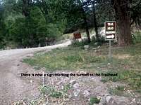
Turn off to TH parking
Red Tape
| This is the latest information as of 9/6/2016. Please take the time to read. Rifeadventures | ||
| I climbed up Lewiston and Flat Top Mountains on 9/3/2016 and wanted to give everyone an update as the latest information I found was from 2013. I went up the new route on the way up as seen if you read runbyu1's update from 2013. Part of the way up I noticed private property signs as we got into the rich forest portion of the trail. I immediately headed back and then bushwacked back up to the saddle where you start to head up the ridge to Lewiston peak. From there it was smooth sailing and I assumed we were off of the private property. After summiting both Lewiston and Flat Top and getting back to that same saddle, we ran into two men who were at the Fuel Cache with their horses and dogs. One of them came up to me and let me know that I was on private property. He said that he worked for the Ault family and was actually really nice. I told him I thought that as long as I stayed south and took the older trail that I wasn't trespassing and he let me know that any way you go up the mountain you are trespassing. He said that they have no real problem with hikers, but that they had problems with hunters as they left garbage and poached animals off of their land. He also showed me an old rock down the way that showed engravings from the Aults from back in 1935, which was really cool. He told me that if you look at On-x maps for hunting you will see where their land ends and where it goes back to BLM land and that it is easy to tell that I was trespassing. After about 20-30 minutes of talking he showed me the best way back down the trail and told me that if I ever want to hike there again that all I needed to do was reach out to Weston Ault of Cedar Fort and ask him if he would be okay with me hiking on his land and he said that Weston would have no problem with it if I asked first. I actually had a great talk with the man (think his name was Justin) and was with him when he saw a hunter trespassing and told me he needed to go so that he could catch him and write him a ticket. Long story short, it was a great hike but if anyone wants to go they will need to get Weston Ault's permission before doing so or there is a chance you will get a ticket for trespassing. Although, if you are a nice hiker I am guessing they will let you go through. One other thing to note, I did download the app for On-X maps and looked at it and it is clear as day that they own the whole Lewiston Ridge and summit and most of the way to Flat Top. I thought Flat Top's summit would be BLM, but it actually looks like it might be owned by another family from the other side of the mountain. So, be warned, no matter which way you go you will be trespassing. But, if you really want to hike this mountain then you can talk to them and I am sure they will let you. |
When To Climb
You could probably climb this peak from the spring to late fall. Winter mountaineering is a possibility as well but perhaps someone can chime in with more information on this. Be wary of thunderstorms on the high ridgelines so plan accordingly. Go early in the morning in summer and get off the peak before 11 or 12.Camping
You could car camp at the saddle (if you can get your car up there) I'd really recommend this as a day hike. Some camping appeared possible in Ophir.Mountain Conditions
No webcams. No local ranger station.One weather link that will give conditions specific for Ophir can be found HERE
Map of area
Book
Michael Kelsey has a neat book containing information on the Oquirrh area and Flat Top in particular in his book "Utah Mountaineering Guide"See the link at the side to order this book as it is the only source of information on both Flat Top and Lowe peaks as well as other peaks in the unknown range.
In his book Mike Kelsey indicates that in dry conditions you might be able to drive a car up to the saddle at 8000 feet. I found that to be true on June 5, 2009 but the road is rough in spots and VERY rocky in others. Yet, my tacoma
made it O.K.
his comments about it. Again, I repeat, park and walk if you have a low clearance 2WD vehicle. Otherwise, you may need a tow truck to rescue you.
powderdave - Sep 30, 2010 11:25 pm - Hasn't voted
Flat Top MountainFYI, the only legal route to Flat Top is "with a helicopter". Ran into several members of the Ault family today. They own a huge amount of land in the southern Oquirrhs. My route took me up and over Lewiston and along the ridge to Flat Top. The family has two hunting camps along the ridge and I was told emphatically that I was trespassing and unwelcome. I ran in to a total of five hunters, all with the family. They hunt deer and elk, with bows, muzzleloaders, and rifles, so they are up there from late summer to late fall. They say their private property even crosses the ridge up to Lewiston. And, you cross private property just getting to the 8,000' trailhead. Must be nice to own the mountains.
Dean - Sep 30, 2010 11:53 pm - Hasn't voted
Re: Flat Top MountainBummer. I was told by one of the Aults that that route was OK (that was after a run in with him when four of us went up from another way) He indicated that the way over Lewiston was the only legal way but it looks like he wasn't speaking for the rest of the family.
runbyu1 - Jul 8, 2013 3:04 pm - Hasn't voted
Re: Flat Top MountainI don't believe you are crossing private property any more on the way up to the 8000' trailhead. There is a 'Loop Trail' and signage the whole way. Locals were very friendly in letting us know we were in the right place and giving us the trail conditions. The rest of the trail had Cairns and seemed legal to me. I wonder if there is a public easement on the ridge and if the Ault's actually have any right to keep people off the ridge between Flat Top and Lewiston. My guess is they do not and I would be shocked if any hiker minding their own business was ever charged for trespassing on the ridge but who knows. My experience on the mountain was positive---there were no 'No Trespassing' signs at any point along the way and the route seemed legitimate.
Rifeadventures - Sep 6, 2016 1:06 pm - Hasn't voted
Re: Flat Top MountainI climbed up Lewiston and Flat Top Mountains on 9/3/2016 and wanted to give everyone an update as the latest information I found was from 2013. I went up the new route on the way up as seen if you read runbyu1's update from 2013. Part of the way up I noticed private property signs as we got into the rich forest portion of the trail. I immediately headed back and then bushwacked back up to the saddle where you start to head up the ridge to Lewiston peak. From there it was smooth sailing and I assumed we were off of the private property. After summiting both Lewiston and Flat Top and getting back to that same saddle, we ran into two men who were at the Fuel Cache with their horses and dogs. One of them came up to me and let me know that I was on private property. He said that he worked for the Ault family and was actually really nice. I told him I thought that as long as I stayed south and took the older trail that I wasn't trespassing and he let me know that any way you go up the mountain you are trespassing. He said that they have no real problem with hikers, but that they had problems with hunters as they left garbage and poached animals off of their land. He also showed me an old rock down the way that showed engravings from the Aults from back in 1935, which was really cool. He told me that if you look at On-x maps for hunting you will see where their land ends and where it goes back to BLM land and that it is easy to tell that I was trespassing. After about 20-30 minutes of talking he showed me the best way back down the trail and told me that if I ever want to hike there again that all I needed to do was reach out to Weston Ault of Cedar Fort and ask him if he would be okay with me hiking on his land and he said that Weston would have no problem with it if I asked first. I actually had a great talk with the man (think his name was Justin) and was with him when he saw a hunter trespassing and told me he needed to go so that he could catch him and write him a ticket. Long story short, it was a great hike but if anyone wants to go they will need to get Weston Ault's permission before doing so or there is a chance you will get a ticket for trespassing. Although, if you are a nice hiker I am guessing they will let you go through. One other thing to note, I did download the app for On-X maps and looked at it and it is clear as day that they own the whole Lewiston Ridge and summit and most of the way to Flat Top. I thought Flat Top's summit would be BLM, but it actually looks like it might be owned by another family from the other side of the mountain. So, be warned, no matter which way you go you will be trespassing. But, if you really want to hike this mountain then you can talk to them and I am sure they will let you. If anyone wants to see screenshots I took from the maps showing that they own the land then send me a message and I will get them to you.
Dean - Sep 6, 2016 5:52 pm - Hasn't voted
Re: Flat Top MountainThanks for taking the time to share your update. Its too bad that this mountain has the private property issues it does but if people will take the time to contact Weston Ault and get his permission, it sounds like the way to go. I'd like to move your info to the RED TAPE section. Thanks again.
PeterVonTrapp - Aug 8, 2012 6:04 pm - Hasn't voted
Flat Top Owner SolvedFlat Top Peak property [Parcel # 58:060:0013]is owned by Marilyn Pratt of 15 East Nova Drive, American Fork, and Utah 84003 AULT FARM PROPERTIES, LLC Owner of Lewiston Peak Property [Parcel # 58:061:0002] among many other properties. Utah County Parcel Map Viewer: Scroll in to see actual parcel numbers. http://maps.co.utah.ut.us:8080/ParcelMap/ParcelMap.jsp Utah County Online Property Search Generally http://www.co.utah.ut.us/LandRecords/Index.asp See Ault Farm Properties, LLC company info and attorney contact below to gain permission across property adjacent to trail along the ridge. https://secure.utah.gov/bes/action/details?entity=6742124-0160 Ault Farm Properties, LLC: Property listings with Utah County http://www.co.utah.ut.us/LandRecords/NameSearch.asp?av_name=Ault+Farm+Properties&av_valid=%25 Registered Agent or Attorney for Ault Farm Properties, LLC. Marc A Austin Utah Bar Registered Attorney Contact info. http://www.utahbar.org/forms/members_directory_search.html Name: AUSTIN, MARC A Member ID: 08138 Member Type: Attorney License Status: Active Firm: MARC A AUSTIN PC Address: 3521 N UNIVERSITY AVE STE 200 Provo, Utah 84604 United States of America Phone: 801-374-8925 Fax: 801-374-0199 E-mail: (Private) Law School: Brigham Young University Graduated: 1997 Bar Admission: 10/20/1998
CharPatton - Sep 26, 2017 5:21 pm - Hasn't voted
? All Private PropertyLooks like from reading a bunch of posts that the trail to the summit is over private land once you leave the access ATV road. I wrote to both Mt. Austin and Mr. Ault asking permission and never heard anything back. I respect their land and property rights, but it would be a very nice community service for them to allow hikers to traverse just the narrow trail to get to the top. Does anyone have any ideas? I offered to donate to a charity of their choice. I wonder if enough people ask politely if they would permit hikers on their property on just the narrow trail???
richh - Jul 5, 2018 12:57 am - Hasn't voted
Re: ? All Private PropertyI emailed Weston Ault [ aultw at msn.com ] on a Wednesday requesting permission asking permission for the weekend to hike around Lewiston Pk. In 2 sentences, short and simple, didn't waste time. In 2 hours he replied with printable permit, and advised which of his people would be up there. The ridge over to Flat Top is not posted.