
|
|
Mountain/Rock |
|---|---|
|
|
32.98281°S / 69.43847°W |
|
|
Hiking, Mountaineering, Ice Climbing, Mixed, Scrambling |
|
|
Winter |
|
|
17831 ft / 5435 m |
|
|
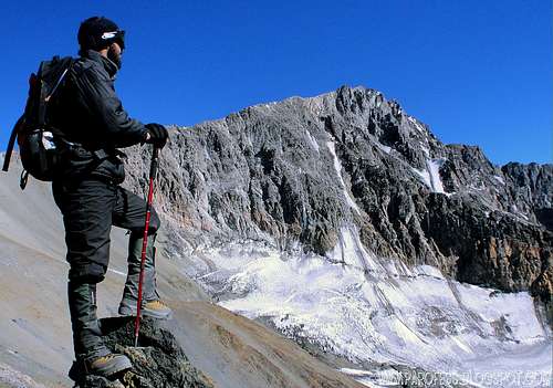
Ok, summit bid here we go!
Located an little more than an hour's drive from Mendoza, the Cordon del Plata Mountains are a popular destination for local climbers/trekkers and sightseeing tourists. In the winter (when there is enough snow), the Vallecitos ski area, located near the trailhead for this peak, opens to serve the local population and travelers with its T-bar lift.
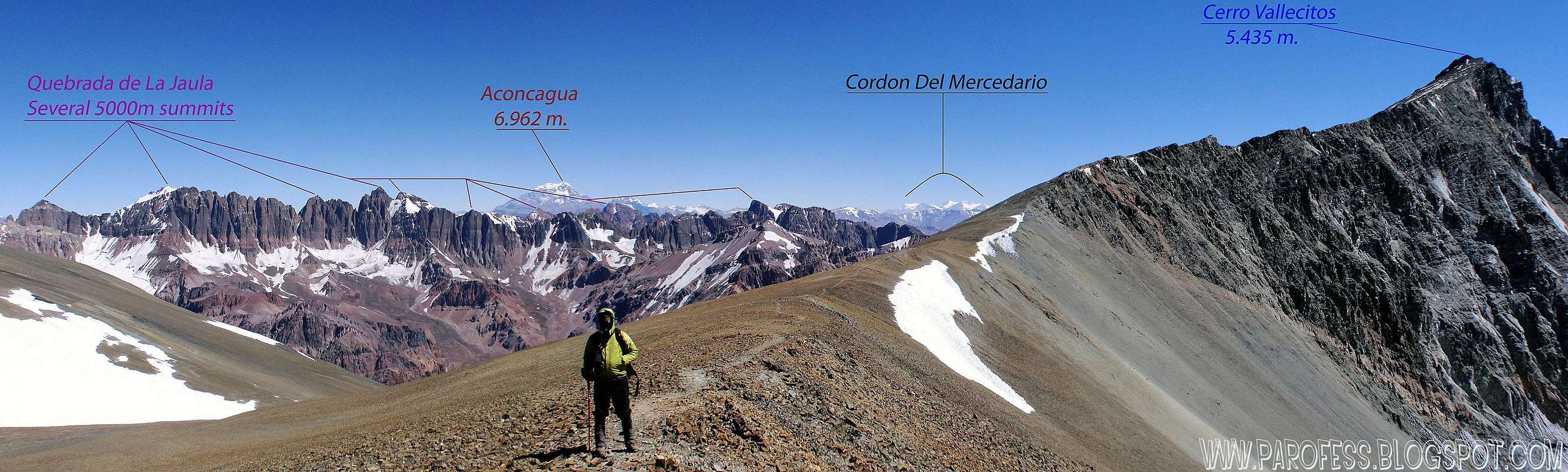
These mountains are also an ideal training ground for climbers headed to Aconcagua. The range is full of peaks topping out at more than 4000 meters, with highest, Cerro Plata, reaching 5938m. This, along with the easy of access from Mendoza, makes the Cordon del Plata an excellent choice for acclimitization prior to your Aconcagua ascent, or if you're a bit of a masochist, allows for a "few more peaks" before heading home while waiting for your departing flight.
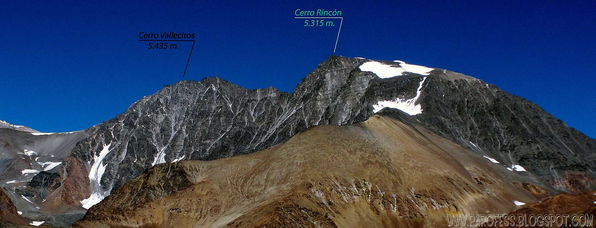
Cerro Vallecitos is one of the "main" peaks of the Cordon del Plata range, together with Cerro Rincon and Cerro Plata. This peak is quite popular owing to the ease of access to it's lofty summit, and the relatively short amount of time required for an ascent. An easy footpath leads up from Salto Camp to the saddle between Cerro Plata and Vallecitos. From there the footpath splits, with the trail heading north ending at the top of Vallecitos. There is a short, class three (YDS) scramble just below the summit.
 |  |  |  |  |
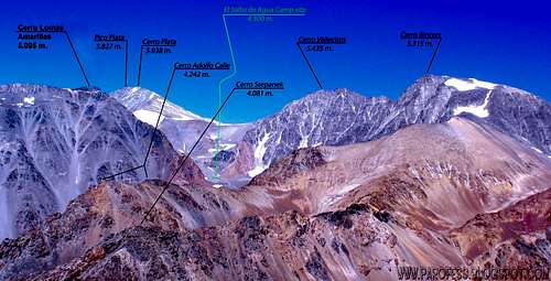
Informational views
View from Portuzuelo at 5.100 m.
View from the summit of Cerro San Bernardo at 4.115 m.
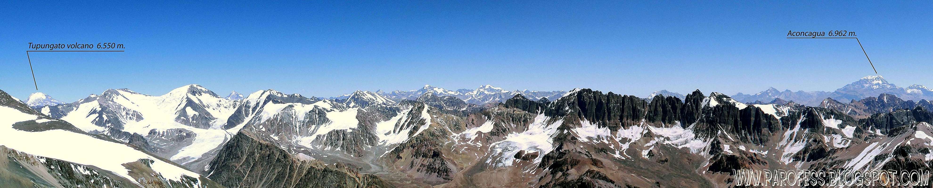
Summit view of Vallecitos.
Getting To The Trailhead
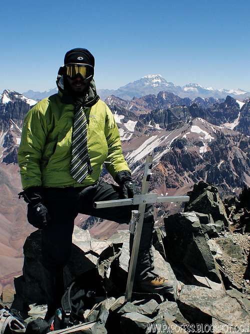
Summit!
The Vallecitos ski area or one of the nearby refugios serve as the primary trailhead for this peak. There are several alternatives for getting to and from the trailhead.
(1) If you have your own vehicle, turn south at Potrerillos from the main highway connecting Mendoza, Argentina to Santiago, Chile. From the small village of Las Vegas, head west up the gravel road to the Vallecitos ski area or the San Bernardo Refugio. The ski area is located approximately 12 km from Las Vegas. The last 3 km of of the road is quite steep and there are many switchbacks.
(2) Transport to and from Mendoza can be arranged through one of the many tour operators which serve Aconcagua climbers, such as Rudy Parra or Grajales. This option makes the most sense for larger groups (4 or more people). These operators generally use small minibuses for transport. In January 2005 the cost was approximately $75 (USD) for a one-way ride to or from Mendoza. You can arrange for the same operator to pick you up after your climb.
(3) Taxi cabs will take you to the trailhead from Mendoza. This makes alot of sense for smaller groups of 1-3 people, and is a much cheaper option than using organized transport services. A cab ride from the main bus terminal in Mendoza to the trailhead (or close to it anyway) cost approximately 100 Argentinian Pesos (approximately $30 USD) in February 2005. Note that most of the cabs in Mendoza run on natural gas (or propane??), and there are no service stations outside of the Mendoza area. Make sure your driver tops off the cylinder before you leave civilization!
(4) I found hitchhiking to be not only the cheapest, but the fastest method of getting back from Vallecitos. The gravel road leading to the ski area gets enough tourists and climbers on it in the high season to assure that you will get a ride within a couple of hours after arriving back at the trailhead. Most people are willing to pick up an obvious climber or two hiking down the road.
Red Tape
There is no need for any permit, etc. to climb in the Cordon del Plata Mountains. This is a welcome relief from the beaurocracy and high cost to enter Aconcagua National Park, or to climb Tupungato from the Chilean side.When To Climb
The best time of the year to climb in the Cordon del Plata is the South American Summer - aproximately Mid-November through the end of March. Rincon could easily be climbed year-round, however, and heading up in the off-season would likely be an enjoyable experience without the "crowds". The refugios near the trailhead are open year round.Camping
Camping is permitted anywhere within the Cordon del Plata mountain range. Practically speaking, for a climb of Cerro Vallecitos camps are generally placed at the following points along the route.
Camp 1: Known as Las Vegas or Las Veguitas, this camp is located in a beautiful meadow at approximately 3200m. This is an easy 1-2 hour hike from the trailhead, and has ample clean water from the spring-fed streams which criss-cross the meadow. Cattle and mules graze here, so it is wise to either treat the water or go to the source of the springs just above camp.
Camp 2: Known as Piedra Grande, is located another 2-3 hours up the trail from Las Vegas. This camp is at approximately 3550m, although the plaque on the "Piedra Grande", or Big Rock, states 3200m. There are many rocks around here, although there is still plenty of vegetation. Several nice spots have been cleared out for tenting. Water is a 5 minute walk to a nearby spring, or closer if you want to filter from the silty stream. Note that during our descent we saw several boulders whizzing down the mountainside through this camp. Use caution - that Piedra Grande didn't just grow there.
Base Camp: Known as Salto or Salto de Agua, is located at approximately 4300 meters and is surrounded by rubble covered glaciers and glacial debris. This camp is used as the base camp for Cerro Vallecitos, as well as Cerro Rincon, Cerro Lomas Amarillas, and Cerro Plata. There is an outfitter permanently stationed here in the high season from which you may order hot food and cold drinks. A small stream runs directly through the camp, and although it looks clean, you are advised to filter or purify the water since there are camping areas above the main base camp along this water course.
Recent update by Parofes in oct 2010:
High camp: La Hoyada camp at 4.670 m. About 1 hour after El Salto de Agua base camp. Hardly used because of strong preassure variation which makes it very hard to sleep, also pretty windy and unprotected.
 |  |  |  |
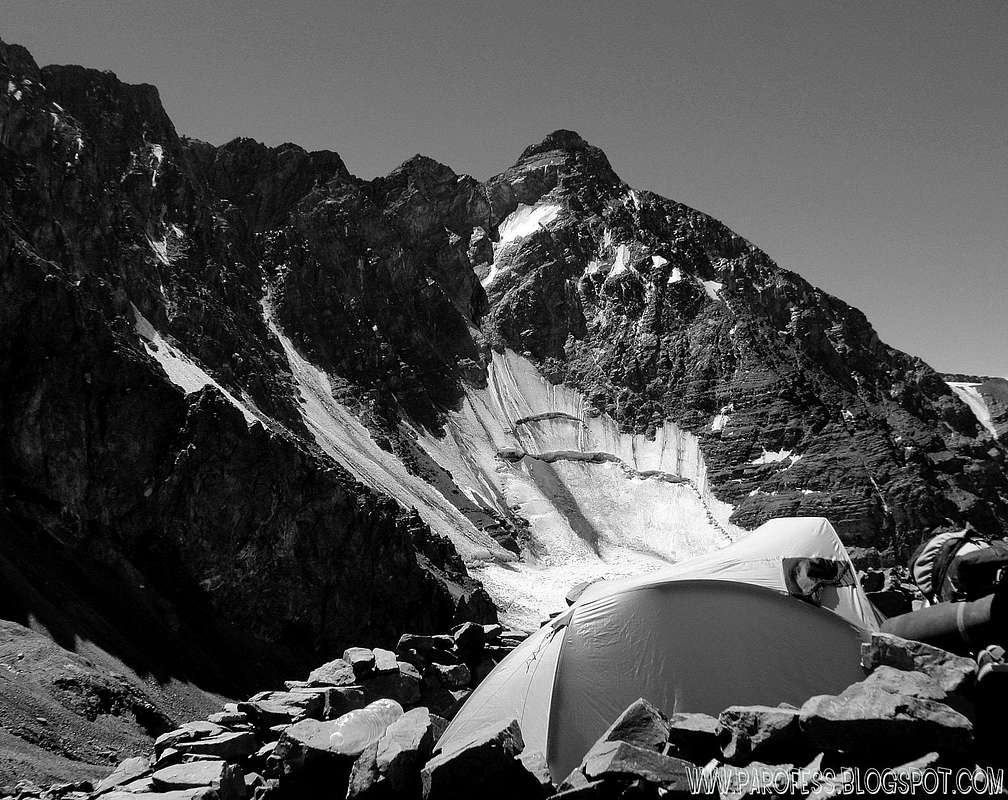
Cerro Rincon from La Hoyada camp, at 4.670m.
Weather Forecast

PS: The weather forecast on this link is good for any Cordon Del Plata summit. Click at the image to jump to the Weather Forecast page.
What is the Elevation of this Peak?
There are wide discrepencies between elevations listed on various maps that I have found covering the Cordon del Plata region. I have seen the summit elevation for Cerro Vallecitos listed as anywhere between 5300 and 5800 meters. If anyone has a GPS derived elevation for this peak I would be most interested.Update!
Author: Corax
Date: Mar 02, 2005 12:12 AM
I climbed the peak two months back.
The elevation I got on my GPS showed 5509m. It should be quite correct as I left the GPS for a long time there and had lots of sattelites in range. The error marginal of that reading should be a max of 30m.
In general, the elevations in Cordon Del Plata are usually lower than for ex. the book about the area tells you. Plata for ex. I measured to 6005m and 6002m on two separate readings. The book says 6300.
Author: Corax
Date: Jan 15, 2006 3:39 PM
I have the new map of Cordon del Plata in front of me. It's based on SRTM-3 Final and the altitude of Pico Vallecitos is given at 5461m.
The weird thing is, the map has no elevation for Cerro Vallecitos.
On other hand, the peak 99% of the climbers go for is the lower trekking summit, not the 10-20 meter higher technical summit.
Recent update by Parofes in oct 2010:
The new altitude for this mountain is 5.435 m. Changed at a new map last year.
Contacts
Club Andinista MendozaFray Luis Beltran 357 Guaymallen
Mendoza, Argentina
clubandinistamendoza@yahoo.com
Cheap transport from Potrerillos (info add in oct 2010):
When i was there in feb 2010 i meet a famous argentinian writer called Jorge Orduna, he is retired now and just takes people to the ski station for little money, usually 80 pesos for two persons at least.
Phone number: (0261) 156125921
Here's a book he wrote and published: http://www.puntaweb.com/cgi-bin/libros/consultar_libro_div.pl?cod=1461
Legal Issues
To hike/ climb is a dangerous activity and requires proper equipment and clothing, the owner of this page cannot be blamed by injuries caused to anyone who read this page for its info about the mountain, and eventually got hurt by doing so with reckless behaviour or bad weather conditions.
Paulo Roberto Felipe Schmidt – AKA: PAROFES
External links
My youtube channel: www.youtube.com/parofes - Now with 270+ videos online!The biggest brazilian website about climbing and mountaineering, for which I'm a columnist:
Corax - Jan 15, 2006 3:39 pm - Voted 10/10
Untitled CommentI have the new map of Cordon del Plata in front of me. It's based on SRTM-3 Final and the altitude of Pico Vallecitos is given at 5461m.
The weird thing is, the map has no elevation for Cerro Vallecitos.
On other hand, the peak 99% of the climbers go for is the lower trekking summit, not the 10-20 meter higher technical summit.
Igor Czs - Jul 31, 2006 11:44 pm - Hasn't voted
explanationHi Corax and everyody! According to some friends of mine (Mountain guides in Mendoza)the Vallecitos peak has two summits: "False" Vallecitos 5470m, wich is the most climbed (the one with the iron stick...or what remains of a metal cross???). True Vallecitos (aprox. 20 higher) is the futher north promotory that one can see from the "false", but best known top summit The latter is dangerous, loose rock and reached few times. The first one, usually climbed is considered technically the summit.....it's the same discussion of the two Ojos del Salado summit...doesnt matter both are te target.;-) Cheers Igor
PAROFES - Oct 1, 2010 2:01 pm - Voted 10/10
NewHello friends According to new measurements in 2009, the new altitude is 5.435m. They did a whole new map last year. Even cerro Plata now has a new altitude of 5.938m. Cheers Paulo