
|
|
Mountain/Rock |
|---|---|
|
|
41.01460°N / 75.0426°W |
|
|
Warren (County High Point) |
|
|
Hiking, Scrambling |
|
|
Spring, Summer, Fall, Winter |
|
|
1577 ft / 481 m |
|
|
Overview
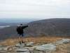
Mt. Mohican is located between Mt. Tammany and Catfish Mountain. Mt. Mohican is also the highest point in Warren County. In some guidebooks it is called Raccoon Ridge because of the many bumps before and after the summit. It offers great views to the East, West, and North, with limited views to the South. The Appalachian Trail travels over the summit. The Kaiser Road Trail is with in one mile of the summit to the north. Sunfish Pond is about one mile South.
What's near Mt. Mohican
Natural features:Sunfish Pond - High on top of the Kittatinny Ridge is a blue lake, Sunfish Pond, a relic of the Wisconsin Glacier (which gouged out a hollow that later filled with water) around 18,000 years ago.
History
In 1870 Sunfish Pond was described as "a sheet of pure transparent water . . . strangely and unaccountably situated on the very Summit of the mountain." (quoted in Pepper 1965:158)
1903 -- millionaire businessman Charles C. Worthington, president of the Worthington Pump Corporation, acquires 8,000 acres on both sides of the river in the Delaware Valley. He erected a small mansion (called Buckwood Lodge) on a hillside half way between the river and Sunfish Pond (which supplied the water for the mansion). At that time, he called the pond: Buckwood Lake.
Worthington used the state forest area as a deer preserve for hunting.
Source
Coppermines- On the Coppermines Trail there are two old coppermines. They were started by Dutch settlers in the 1600's. As it turns out there was not much copper in the hills of New Jersey, but it did not stop the miners from digging and starting other mines on the Kittitanny Ridge. There are other mines near Sunrise Mt in Stokes State Forest.
Getting There
Appalachain Trail North Bound trail head- Sceond to last exit in New Jersey on I-80 West. First Exit for East Bound. Park at the information center and head north on the A.T.Appalachain Trail South Bound Camp Road/ Mohican Outdoor Center
Summary: From New York City, eastern Connecticut, and points north:
1) New York Thruway south to 287 south to Route I-80 or GW Bridge to I-80
2) Take I-80 west to Exit 12 (NJ 521) Take right fork in exit, follow signs for Blairstown.
3) NJ 521 north to NJ 94 turn left (south)
4) NJ 94 south for 1.1 miles thru Blairstown to Mohican Rd
5) Right on to Mohican Road
6) Follow directions below from Mohican Road
From central New Jersey:
1) Rt- 31 north until it ends
2) Left on NJ 46 west approx 1 mile to NJ 519
3) NJ 519 north to NJ 521 in Hope
4) NJ 521 north to NJ 94, turn left (south)
5) NJ 94 south for 1.1 miles thru Blairstown to Mohican Road; Right on to Mohican Road
6) Follow directions below from Mohican Road
From Pennsylvania & Philadelphia:
1) NE Extension of PA Turnpike to US 22 East (Lehigh Valley Exit #33)
2) Take US-22 east to PA-33 North
3) PA-33 North to I-80 East
4) I-80 east to NJ-94
5) NJ-94 north about 7 miles to traffic light, new A&P Shopping Center on left
6) about 1 mile past light turn left on Mohican Road
From Mohican Road:
7) Follow Mohican Road 3½ miles to Gaisler Road CAUTION: This is a winding-road with
several forks always bear right at the Ys.
8) Turn left on Gaisler Road and go ½ mile.
9) Turn right on Camp Road (just before "Children Playing" sign). This turns into a dirt road.
10) Cross the Appalachian Trail.
11) You will come to an unlocked gate, drive thru.
12) When you see the Lodge on left and a double garage on the right, stop, park and come in to the lodge to registe
Coppermine Trail Parking Lot -Take the Last exit in New Jersey (Exit 1) and turn right on Old Mine Road for 7.8 Miles Parking lot is on the left side of the road. Trail starts on the other side of the road.
Red Tape
Appalachian Trail Governing RegulationsCarry out all trash.
Pets must be on a 6-foot leash at all times.
Horseback riding and bicycle riding are prohibited on the Appalachian Trail within Delaware Water Gap National Recreation Area.
All types of motorized vehicles are prohibited on the Appalachian Trail, except authorized emergency vehicles.
Cutting, defacing, or removing any natural feature is prohibited.
Self-contained stoves are permitted; ground fires are prohibited. Charcoal stove and grills are prohibited.
Camping is restricted to through-hikers who are hiking for two or more consecutive days.
Camping is limited to one night per campsite.
Camping is limited to ten persons per campsite.
Hikers MUST CAMP within 100 feet of the Appalachian Trail.
Hikers MAY NOT CAMP within 1/2-mile of an established roadway
Hikers MAY NOT CAMP within 200 feet of another camping party
When To Climb
Can be climed all year. Conditions of Dry, Muddy, Snowy, and Icy have been encountered.Camping
See Red Tapeor...
You can camp at Worthington State Forest, not far, for a fee, or at backpacker site #2 along the Appalachain Trail before Sunfish Pond (North Bound)
The Worthington State Forest Website
Mountain Conditions
Delaware Water Gap Weather InfoSummit Pics.
Post you summit pics here.
 |  |
External Links
- Another SP type site but less cool
- The New York-New Jersey Trail Conference
The offical website of The New York-New Jersey Trail Conference
- Info on New Jersey Hiking
Info on Mt. Mohican (a.k.a.) Racoon Ridge
michaelira - Dec 4, 2009 10:34 pm - Hasn't voted
Mount Mohican NOT the Warren County HighpointThe actual Warren County highpoints are two unnamed 1600+ ft. bumps near the upper Yards Creek Reservoir. See cohp.org (look under New Jersey trip reports) for a description, trip reports, and links to maps.