
|
|
Mountain/Rock |
|---|---|
|
|
47.02640°N / 115.0705°W |
|
|
Shoshone |
|
|
Hiking, Mountaineering, Skiing |
|
|
Spring, Summer, Fall, Winter |
|
|
7690 ft / 2344 m |
|
|
Overview
Illinois Peak lies on the border of Montana and Idaho, in the Northern Bitterroot mountains (I heard some locals pronounce it "bit-ter-it" ..?). Illinois Peak primary attraction is probably that it is the highest point in Idaho's Shoshone county. It lies on the border of Montana and Idaho, and interestingly only about 25% of it lies in Idaho.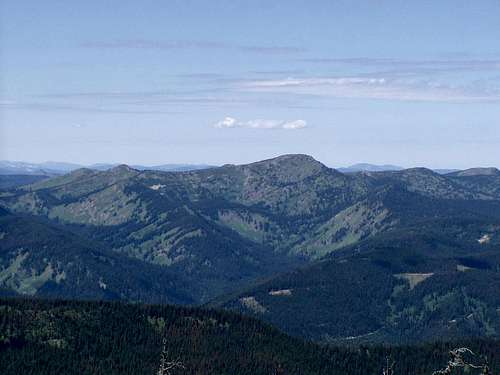 Illinois Peak from the E/SE on Quartz Peak, HP of Mineral county Montana
It used to have a fire lookout near the summit, but only foundation blocks now remain. Continuing the state and county border sharing theme, it continues the sharing by sitting on the border of Lolo and St. Joe national forests (Lolo in Montana, St. Joe in Idaho). This peak could reside in the Montana section of Summitpost.org, but since it is a county highpoint, I chose to list it in Idaho. It is approximately the third highest peak in the Northern Bitterroot mountains.
There is a relatively easy class 1 trail from Freezeout Pass in Montana. A 4wd vehicle can drive closer to the peak, where passenger vehicles will stop at the pass. I had heard that multiple registers were at the summit, but when I went, I saw none. It seems to be moderately popular since its trail is short, and it has decent/quick access from the Montana side. A round trip hike from Freezeout Pass is roughly 5 miles.
Getting There
The easiest access seems to be from Freezeout Pass in Montana.Montana
From I-90 in Montana, take exit 47 and drive SE on a frontage road on the South side of the freeway. Approximately 1.3 miles later, watch for a sign for Forest Road 320 and Cedar Creek Canyon. The sign also shows "GilDERSlEEVE MINE 17.5 Mi". Take a right and proceed up the canyon. The road turns to gravel eventually. Veer left at a fork with FS road 7865 (stay on 320). At a fork with FS road 388, go left. Follow 388 up to Freezeout Pass. You will pass a few mines that are still operational along the way up the switchbacks. As of September, 2004, there was a sign visible to southbound traffic pointing to Trout Creek Driveway , trail 169 at the pass.
For passenger vehicles, this is the start of the trail. With four wheel drive, you can continue up the ridge road (there are multiple roads here heading West at the pass) for a mile or so if you don't really care for hiking, or have time constraints. I don't see why you would drive it, but it is up to you.
-----------
One could also approach by continuing on FR320 listed above all the way to the MT/ID border. From the border, hike SE on the ridge for 4-5 miles to the summit. Lopez's guide indicates that this approach is suitable for passenger vehicles in "good weather."
Idaho
From Idaho, one can travel up the St. Joe River drainage to its end at St. Joe Lake where one can start the hike.
From Avery, travel East on the St. Joe River road, which should be FR50. Once the road reaches Gold Creek, it changes to FR218 (still St. Joe River road), while FR50 heads NE. Through its entirety, this route follows the St. Joe river, which should help in navigation since there are several roads that branch off. Watch for FR320 (Red Ives Creek road) near the end of the River Road. Follow it until it crests on the ID/MT border. At this point, you can start the hike along the ridge all the way up to the summit. Apparently FR320 can become rough for passenger vehicles on the ID side after it leaves the river.
An decent quality road map for Idaho and Montana can be found on the Idaho Panhandle National Forest site (be advised, it is a 1.7MB download).
If anyone else has experience with the approach from the southwest through Idaho, please post!

Red Tape
No permits, no fees- all Forest Service land. Inquire with the Lolo National Forest, Superior district for access conditions from Montana depending on the season: (406)822-4233. From Idaho, check with the IPNF St. Joe Valley offices: (208) 245-2531 (St. Maries) and (208)245-4517 (Avery).When To Climb
Summer and Fall would be ideal. Depending on how close you could get in winter, It could be skied since the trail is mostly on or near a ridgeline.Camping
There are some improvised looking campsites along the 4wd road (from Freezeout Pass) in the trees, The closest National Forest campground seems to be Trout Creek. Trout Creek is open year round, has 12 sites, and is $6.00 per site. It is located about 7 miles SW of superior on FS road 257. For others, check the Lolo National Forest camping site.Also check the Idaho Panhandle National Forest's camping/recreation page for camping on the Idaho side in the St. Joe drainage. One campground of interest is Heller Creek. It indicates that there is a gravesite at the actual campground. Heller Creek is on FR320 that can be accessed from ID or MT.
Mountain Conditions
Forest ServiceSuperior Ranger District
PO Box 460
209 West Riverside
Superior MT 59872
(406)822-4233
Office hours: Monday-Friday 8:00 - 4:30
Directions: From Interstate 90, take the Superior off-ramp. Coming from the west, take a left at the stop sign and drive into town a few blocks; coming from the east take a left as the stop sign and at the next stop sign turn right. Just before the bridge, turn left onto West Riverside Avenue, go two blocks down and the ranger station is on the left hand side.
From the Idaho side, check the Idaho Panhandle National Forest site.
St. Joe Ranger District
St. Maries Office (located in Federal Building in downtown St. Maries)
P.O. Box 407
St. Maries, ID 83861-0407
(208) 245-2531
Avery Office (6 miles west of Avery on Forest Hwy. 50 (St. Joe River Rd.)
HC Box 1
Avery, ID 83802-9702
(208)245-4517
Weather
Intellicast weather forecast for Lolo NF
Avalanche conditions
Current Western Montana forecast
bjg1021 - Sep 14, 2013 2:46 pm - Hasn't voted
Trailhead Location UpdateI visited Illinois Peak September 13, 2013 and the first mile of the trail is no longer derivable to highway vehicles. There is a kelly hump and boulders preventing travel to all but dirt bikes at the Freezout Pass Trailhead. Exceptional hike though- includes a stroll through one of Montana's only mountain hemlock forests!
montanahiker40 - Mar 4, 2018 6:59 pm - Hasn't voted
Wrong state listedIllinois Peak's summit and more than 60% of the mountain are in Montana, NOT Idaho. I've been there when a certified surveyor took new GPS measurements and it's a Montana mountain by default. https://www.topoquest.com/place-detail.php?id=785223