
-
 28343 Hits
-
 84.94% Score
-
 21 Votes
|
|
Mountain/Rock |
|---|---|
|
|
40.42560°N / 112.1989°W |
|
|
10589 ft / 3228 m |
|
|
Overview
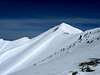
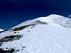
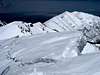
Lowe Peak is located near the southern end of the Oquirrh (pronounced "oh-ker") Mountains, a roughly 30-mile long range running north-south along the west side of Salt Lake Valley. With an elevation of 10,589 feet the peak is the second highest mountain in the range, coming in just a shade under 10,620 foot Flat Top Mountain, which lies approximately 3.5 miles to the south. The peak lies on the border of Utah County to the east and Tooele County to the west.Despite its proximity to the Salt Lake Valley the Oquirrh mountains go largely overlooked by hikers, with the vast majority of the attention focused on the nearby Wasatch Range. Access to the area is somewhat complicated due to the large amounts of privately owned land in the area.
The name "Oquirrh" comes from Goshute Indian word meaning "wooded mountain". An extensive background on the mining history of the area can be found at this website. A large elk herd is known to frequent the area around the peak.
From the summit are excellent views looking east at much of the Wasatch Range. Notable peaks visible include Broads Fork Twin Peaks, Lone Peak, Box Elder Peak, Mount Timpanogos, Cascade Peak, and Provo Peak. Utah Lake is also visible to the southeast. Looking along the ridge extending south is Flat Top Mountain, the highest point in the Oquirrh Mountains, and Deseret Peak can be seen to the west.
USGS Quads:
 |  |  |  |  |
Getting There
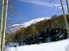
From the standpoint of ease of access and to avoid issues over privately owned land, the peak is best climbed from Ophir Canyon, which begins near the old mining town of Ophir, Utah. Refer to the Ophir Canyon route description for details on ascending the peak.To reach the town of Ophir proceed as follows:
From I-15
Take Exit 282 (Lehi) and follow State Route 73 for approximately 40 miles to the turnoff for Ophir. The turnoff is located midway between mile markers 4 and 5 on Route 73. Turn right (east) and proceed ±3.5 miles to the town of Ophir.
From I-80
Take Exit 99 (Tooele/Stansbury) and proceed south on State Route 36 for approximately 23 miles to the junction with State Route 73. Turn left (east) and follow Route 73 for 4.5 miles to the turnoff for Ophir on the east side of the road, then proceed ±3.5 miles to the town of Ophir.
Michael Kelsey's book "Utah Mountaineering Guide" also describes options for ascended the peak from the east, but routes on this side of the mountain require passing over private property.
 |  |  |