
|
|
Mountain/Rock |
|---|---|
|
|
35.74870°N / 82.2757°W |
|
|
6391 ft / 1948 m |
|
|
Overview
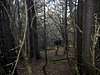
Located in the Black Mountains of North Carolina, Mt. Hallback is a nice southern sixer that offers a little bit of everything. The trail begins with a nice gradual ascent that turns into a rock laden trail, which eventually gives way to an excellent beginner bushwhack. There are limited views from the dense summit. Hallback is one of the highest points east of the Mississippi River.
 |  |
Getting There
From Asheville take NC hwy. 70 to the Blue Ridge Parkway. From BRP go toward Mt. Mitchell. Park at the ranger station at Stepps Gap. Mt. Hallback is the mountain behind the ranger station. To access the mountain take the Old Mt. Mitchell trail 0.25 miles to the top of the first incline. This portion of the hike will take you through an area littered with fallen trees. Once you reach the top to the incline walk about 20-30 meters. Follow one of the several clearings to a final area of woods then bushwhack the rest of the way to the top of the mountain. The summit is marked by a wooden sign.
 |  |  |
Red Tape
None of the above
When To Climb
This area is usually closed during the winter months. Early to late spring and late fall are the ideal times to visit Hallback.
Camping
There is a pay camping area located up the road toward Mt. Mitchell on the right.
Redwic - May 13, 2009 3:44 pm - Hasn't voted
This should be included...... on the "Black Mountains" SP Area/Ranges page. It looks like the only one missing from there.