
|
|
Mountain/Rock |
|---|---|
|
|
43.10000°N / 19.00000°E |
|
|
7851 ft / 2393 m |
|
|
Overview
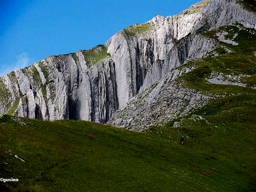
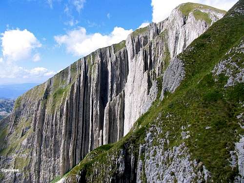 Impressive vertical sedimental layers of Prutas (2393 m)
Prutaš (2393 m) (read Prutash) is one of the most beautiful, most popular and the largest of DURMITOR peaks. Nowhere on Durmitor you cannot have so impressive, breathtaking and unforgetable view as from Prutaš summit. Prutaš is really the King of Durmitor's viewpoints peaks!
View from viewpoint of Prutaš is simply amazing and breathtaking, better than photos can show. Durmitor's best alpine panorama! Looking photos from Prutaš summit, somebody can thinking that this is somewhere in Switzerland, in Alps.
Prutaš is really something worth seeing, not only on Durmitor but afar. It is softly sloped, deep green, and adorned with oblique “Prutovi” (wands) – which, by the way, stood godfather for it’s name. Prutas got it's name from its cliffs called "Prutovi'"which is plural of the word "Prut" which means a twig or branch. "Prutaš" means - a mountain made of twigs. If a peak can take the first place among all for a nice climb, and for enjoying a most beautyfull high-mountain sight, it for sure is Prutaš.
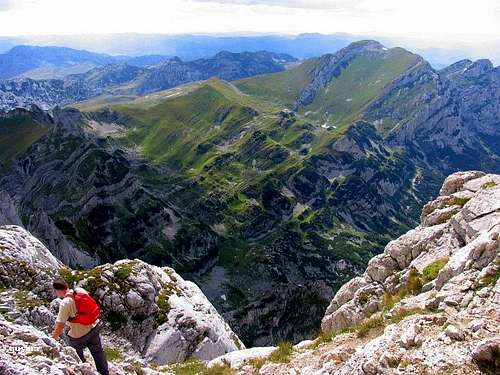
 Incredible Durmitor from Prutas
What is distinction, for example, between Bobotov Kuk (2523 m) summit view and Prutaš summit view? Simply, summit view from Bobotov Kuk is very impressive because this is highest point of Durmitor massif. Everything what you can see from Bobotov Kuk is lower than you on the top of this peak. But, nowhere on Durmitor you can't enjoy in so impressive alpine scenery and atmosphere of Durmitor highest peaks as from Prutas summit.
From no other peak, Bobotov Kuk (highest peak of Durmitor) looks so impressive and amazing as from Prutaš summit. On Prutaš summit and it's beautiful grassy slopes you can enjoy whole day in the most beautiful alpine panorama of Durmitor massif.
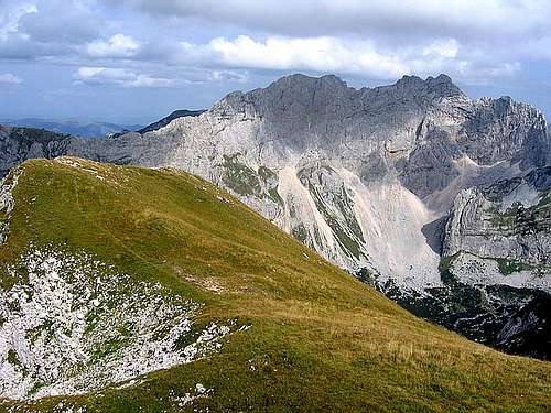
In front of Prutaš summit are placed main and highest crest of Durmitor called "SOA NEBESKA" which means "Altar of the Sky". This 2 kilometres long and about 800 m high rocky wall contain three peaks - Bezimeni Vrh (2487 m), Bobotov Kuk (2523 m) and Djevojka/Soa (2440 m). South Face of SOA NEBESKA proudly stay above most beautiful corner of Durmitor massif - glacial cirque Skrcka Lakes Valley, in which are located two beautifully lakes, Veliko Škrčko Jezero (Large Škrka Lake, 1686 m, 15.2 m deep) and Malo Škrčko Jezero (Small Škrka Lake, 1711 m, 17.2 m deep). On grassy plateau between this two lakes you will find house with red roof - mountain hut Skrka, where you can sleep and eat during your hiking adventures in this part of Durmitor.
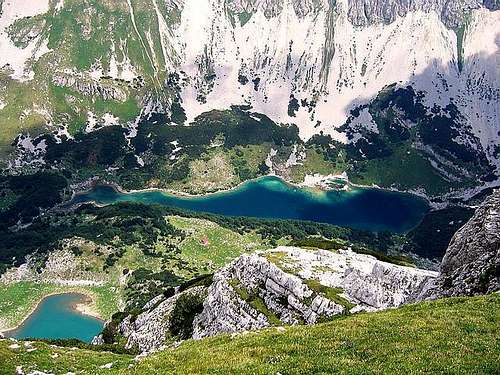 Skrcka Jezera (Skrka Lakes) from Prutas
LOCATION:
Prutaš is placed in the western part of southern central Durmitor. On the N is Gruda (2302 m), from which it is separated by Ilin Do (2230 m) pass. Gruda and Prutaš in way make southern end of the crest that makes western side of Sušica river canyon (read Sushica). Over the Ilin Do pass western approach from Todorov Do leads. On the NE is amazing Skrka valley (read Škrka) with its two extraordinary lakes - Veliko & Malo Škrčko Jezero (Big & Small Skrka Lake).
700 m high Prutaš North Face prodly dominates above Skrcka Lakes. North Side is made of layered cliffs with grassy terraces which fall down to Škrka valley and to Štit and Samar pass. On the E very steep grassy slopes of Prutaš descend into the Prutaški Do (2007 m) basin. Lowest point of the ridge is narrow pass called Skrcko Zdrijelo (2114 m). SE of the pass is Štit (2248m), very special peak on Durmitor because of it's form and outlook. Over the Skrcko Zdrijelo pass southern approach from Dobri Do leads. S side of Prutaš, which falls into the Govedji Do basin (around 2000 m) have most dramaticaly outlook.
ACCESSIBILITY:
Prutas is easy accessible from Zabljak – Virak – Trsa macadam/country road, which passes along the southern and western foot of Prutas. Dobri Do and Todorov Do trailheads are on the road and from Dobri Do also Skrka valley is only 2:30 h away. But during winter, when this road is not cleaned of snow, Prutas becomes most difficult corner of Durmitor to access. In winter time, very few people try to reach Prutas summit. Better period for that trip is spring, summer and autumn, from April/May till September/October, because before and after that is snowy season.
SUMMIT VIEW:
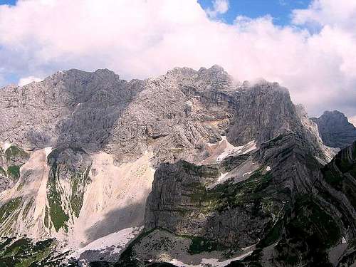 800 m high wall of SOA NEBESKA from Prutas (2393 m)
View from the summit of Prutas is breathtaking!!! From here it is most beautiful view of Skrka Valley and highest peaks of Durmitor, Bobotov Kuk (2523 m) and Bezimeni Vrh (2487 m), which proudly dominates above Skrka Valley in NE direction. Right from Prutas is situated colorful Stit (2248 m) with its very special colorful layers, on the E. On the N is Susica canyon and Ljubisnja mountain farther away. On the S are vast grassy plateaus and basins of Durmitor with Sedlena Greda (2227 m), Boljska Greda and Lojanik and entrance of Komarnica river canyon. Further away is Vojnik mountain. During clear days , far on S you can see Orjen massif and Adriatic Sea. On the W are Pivska Planina. Behind it is located wonderful group of mountains - Bioc, Volujak and Maglic, highest peak of Bosnia & Herzegovina.
If you are visiting Durmitor - don't miss a Prutas, the best viewpoint to biggest beauty of Durmitor - Soa Nebeska wall (highest peak of massif) and to amazing Skrcka Lakes valley. Also, you will see beautiful Susica Canyon.
 |
 |
 |
 |
 |
Routes Overview
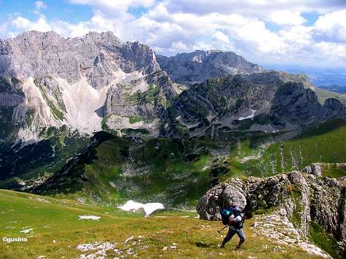
 Ascent on Prutas (2393 m)
1. Southern approach: Dobri Do (Sarban water spring, 1700 m) - Skrcko Zdrijelo (2114 m) - Prutas (2393 m): 2.15 h.
Prutas (2393 m) - Skrka Lakes valley (1686 m) - 1 h.
2. Western approach: Todorov Do (Pistet water spring, 1820 m) - Ilin Do pass (2230 m) - Prutas (2393 m): 1.30 h.
3. Northern approach: Skrka Lakes valley (1686 m) - Prutas (2393 m): 2 h.
4. Eastern approach: Sedlo pass (1907 m) - Uvita Greda - Surutka 2042 m (or Trojni Prevoj pass, 2245 m) - Zeleni Vir Lake (2028 m) - Samar pass (2075 m) - Prutas summit (2393 m): 3 h.
The easiest approach to Prutas (2393 m) summit is southern approach - via Dobri Do valley and Skrcko Zdrijelo (2114 m) pass. This is route for everyone, also for the older people. Not difficult. Beautiful hiking tour!

Prutas from Djevojka

From Todorov Do
The western approach is little beat more difficult, with one exposed place (5-6 meters), 15 minutes before summit. This approach is more steep than southern.
Who like easier and more secure route can practice southern approach. Those who like to get a great award (summit panoramas) after effort during steep ascent, can choose western approach.
Both approach finally meat same place - Prutas (2393 m) summit. If you want to see south-western face of Prutas from Valoviti Do valley, you can choose western approach. But you must know that this appraoch is little beat more difficult than southern. Southern approach is without exposed places, while western have one exposed place (just a few meters, using of hands is necessary).
From Zabljak town (1450 m) to Virak village (1480 m), Sedlo pass (1907 m), Dobri Do (Sarban water spring, 1700 m) and Todorov Do (Pistet water spring, 1820 m) - by car or taxi. Taxi price: from Zabljak to Sedlo pass, one direction -20 Euro for larger group till 7-8 person, 2,5 euro per person. From Zabljak town to Dobri Do and Todorov Do and back to Zabljak (in the evening, after your climbing), for maximum 3-4 person - 25 Euro.
The road from Stozina (below Stozina peak, 1908 m) to Sedlo pass, Dobri Do and Todorov Do - macadam road.
 |
 |
 |
 |
 |
Getting There
 Magnificent Prutas summit view
Gateway to Prutas (2393 m) peak on Mt Durmitor is Zabljak town. Information how to get there:
By Plane
~To Beograd (Belgrade, Serbia&Montenegro capital) airport. Than with plane to Podgorica, capital of Montenegro, or with bus or car to Zabljak town.
~To Podgorica airport. Than with bus or car to Zabljak town.
Information about flights find on the sites of JAT Airways, a former Yugoslav airlines, or on Montenegro Airlines.
By Bus
~Beograd (Belgrade)-Zabljak
~Podgorica-Zabljak
~Niksic-Zabljak
~Pljevlja-Zabljak
Buses go to Zabljak from Beograd (Belgrade) twice a day and from Podgorica, Niksic, Pljevlja and Mojkovac several times per day.
By Car
~Beograd (Belgrade)-Zlatibor-Nova Varos-Prijepolje-Pljevlja-Zabljak
~Niksic - Savnik (47km) - Zabljak (37km): 84km; Niksic to Zabljak approach from south.
~Niksic - Savnik (35km) - Zabljak (37km): 72km;
~Podgorica - Niksic (55 km)-Savnik (47 km)-Zabljak (37 km): 139 km; Add this length if you are going to Zabljak from Podgorica via Niksic. Road to Niksic from Podgorica is good.
~Podgorica - Kolasin (71km) - Mojkovac (21km) - Zabljak (67km): 159km; road is good all the way to Zabljak. Behind Podgorica (56m) you go inside Moraca River canyon (one of spectacular Montenegrin canyons). It is up to 1000m deep and has wild sides. That's spectacular drive. After that, from "Djurdjevica Tara" bridge to Zabljak - 23 km.
From Zabljak town till foot of Prutas peak you must go follow Zabljak - Virak -Trsa macadam road (about 30 minutes by car or taxi).
 |
 |
 |
 |
 |
When To Climb
 Prutas from Bobotov Kuk (2523 m)
Durmitor is typical summer hiking mountain. From October to June it is under snow and from mid June to mid September is the best time for climbing. Of course, Durmitor can be climbed during whole year, during all year seasons. Normally, full winter equipment is necessary in winter time. February and March are the best months for winter climbing activities on Durmitor.
During the winter, Durmitor usually switches into ski resort. Under Savin Kuk peak (2313 m) is Durmitor Ski Center. (gondolas, ski lifts, chair lifts, restorants and their customers).
Crno Jezero (Black Lake) location is a common climbing starting point. All major trails further uphill are well marked with white circle/red border marks.
Whole Durmitor mountain is very good marked. Thanks to Branislav Cerovic, greatest knower and devoter of Durmitor National Park, who marked all routes on Durmitor mountain.
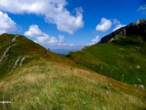
 Going to Prutas summit

Prutas in winter above Skrka Valley
Prutas (2393 m) peak can be climbed whole year except winter time when this peak is not easily acessible, because the macadam road Zabljak-Dobri Do-Trsa is under snow and is not clean and approach is difficult in this time. You can try to climb Prutas in winter follow next instructions: after Bobotov Kuk climbing you can descent to Zeleni Vir glacial lake plateau and than go across Samar (2075 m) pass inside of Skrka Valley, left-up to Prutas summit. But, recommendation is - better climb Prutas summit in all times except winter time. Maybe good time after winter is spring time, when the macadam road Zabljak-Virak-Trsa is clean, but on mountain you can still find snow and feel "winter feeling" of Durmitor.
 |
 |
 |
 |
 |
Camping

Prutas above Skrka Hut (1723 m)
Camping permitted on camping dedicated spots only.
Major huts are in good condition, but with no service. Still, open to the general public. Hikers/climbers are supposed to bring all the jummy stuff with them.
On Durmitor exist camp in Ivan Do and few ~mountain huts and bivouacs:
~Hut with few small shepherd's houses in Lokvice valley
~Hut in Skrcka Lakes valley
~Bivouac in Velika Kalica valley
~Shepherd hut "Mushova koliba" on the road from Zabljak to Obla Glava (2303 m) peak, near Ledena Pechina (Ice Cave) - empty simply shepherd hut from wood, without service, simple conditions...
~In Ivan Do camp price for camping is 4 Euro per day.
Also, in Zabljak town you can rent private room or apartment. Price for 2-beds apartment with kitchen and bathroom: 10-12 Euro (5-6 Euro per person).
In some villages on mountain, for example in Bosaca village, you can rent a 2-beds apartment for price 6-8 Euro (3-4 Euro per person) with free milk products every day (1 liter of caw milk).
The best camping place for Prutas climbing is Skrka Hut (1723 m) in Skrka Lakes Valley!
 |
 |
 |
 |
 |
Mountain Conditions
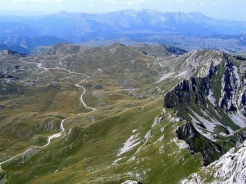 Todorov Do valley from Prutas
Durmitor (Zabljak town) 5-7 days weather forecast
 |
 |
 |
 |
Red Tape
No fees or extra fees for entering the National Park.
No permits needed either.
Usual rules of behaviour for NPs do apply.
 |
 |
 |